Clouds hold over a good chunk of the state today, although we are optimistic that we see some sunshine break through as the day wears on over the southern half of the state. Leftover moisture this morning may fall over extreme eastern Indiana, where we saw some light action build overnight. However, that will move quickly off to the east. Strong northwest winds will develop through the day, and that will bring much colder air into the region. That cold air advection, coming in across Lake Michigan, will likely increase our potential for some lake enhancement later this afternoon, evening and overnight. That is causing us to put a little bit of light snow into the forecast for this afternoon through tomorrow morning over the extreme northern part of the state. We do not think we will see any significant accumulations, and snow in general probably has a hard time holding together south of SR 14…but still, it is a minor change in our forecast.
 Dry for most of tomorrow, Saturday and early Sunday. Winds swing back to the southwest, meaning we see temps bump up again going into the holiday weekend. However, we are still on track to get some significant precipitation as we finish out the extended holiday weekend. Clouds build from later Saturday through Sunday, and we see light rains starting to move in late Sunday afternoon and evening. The rains pick up in intensity for Monday and then linger into Tuesday. Rains are not going to be overly heavy in any specific period, but the threat of rain will be fairly constant from Sunday night through Tuesday morning. All told, we look for cumulative rain totals to be from .5”-1.25” over 90% of the state, and some areas may even push closer to 1.5 inches on a localized basis. The northern half of the state will see better chances for rains in the upper half of the range. The map above shows cumulative precipitation through next Tuesday morning. The 2 inch totals on this map are overdone, in our opinion. But the layout of the geographic spread is very close to our thoughts.
Much colder air comes in behind the cold front around midday Tuesday, and we will see temps pushing to below normal levels for most of the rest of the week next week. We do not see any serious precipitation threats through the balance of the week. We may see some lake effect snow try and sneak into some far north areas late next Tuesday into Wednesday, and a few flakes flying over southern Indiana for next Thursday night, but the threats are minimal. We likely stay dry stay dry right on through next weekend.
In the extended period, we look for a significant front to work in to the state, bringing the potential for liquid equivalent precipitation of half to 1 inch. However, models have major discrepancies in how they handle different air masses with any front. The GFS is way too warm for the extended period, in our estimation, with a big push of warm air all the way up into the northern plains. However, the European does not have nearly as intense of frontal development. So…with the big disparities, we will have to see how this one plays out going forward. Our bias is for a strong front with a much stronger cold push…we have been in that camp for a while now, calling for a big blast of cold air for January. Who knows how long it will take to get some of these models to come around to that line of thinking.
 However, from overnight Sunday night through Monday and even into early Tuesday, we see nice, steady rains developing and slowly moving through. That should be enough to bring half to 1 inch rains to 100% of the state, with Monday (the 2nd) being very, very soggy. The map show a snapshot of action late Monday afternoon.
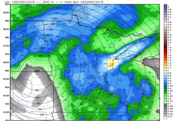

 potentially a lot less. Still, it will turn out to be a pretty gray and somewhat damp Christmas Day over a large part of the state.