We kick of yet another work week with most of the state looking dry and fine today. The northern two thirds of the state will see plenty of sun today, pleasant afternoon temps (actually just a little bit below normal) and a nice breeze with low humidity. Then, we have the southern part of Indiana, that just can’t come along for that ride today. A strong low is moving across the Tennessee valley and Kentucky, pushing rain and thunderstorm action north across the Ohio river as it moves east. This will trigger rain and thunderstorms over southern Indiana, mostly from US 50 southward, through the day today. In SW Indiana this morning we can see some heavy rains of 3-4 inches with strong thunderstorms, and that rain tracks east through the day, easing some, but not completely. So, in southern Indiana, particularly near the river, look out for heavy rain, potential flooding, strong thunderstorms and the possibility of severe weather.
Tomorrow will be partly sunny to start, but rain will be filling in over IL to our west. That rain may nose some scattered showers in to western Indiana by midday to mid-afternoon. In general, though rain waits to ramp up until Tuesday evening and overnight, and then goes all the way through Wednesday. Half to 1.5” rain totals are likely with coverage of 90% of the state. To get to the upper end of the range we need thunderstorms, but we think that there can be some strong to possible severe thunderstorms on several occasions through the life of this event.
Thursday we can see some scattered showers from I-70 southward, but those likely give only a quarter to half an inch with 60-% coverage. The rest of the state north of I-70 will be dry. Friday, we flip that. Scattered shower in NW Indiana bring .1” to .5” with coverage at 40%, and we stay dry elsewhere. WE are dry Saturday and Sunday statewide.
Scattered showers and thunderstorms return from US 24 northward Sunday night into very early Monday morning. This minor precipitation outbreak can bring a few hundredths to almost 1 inch (most of that heavy rain stays in Michigan), but coverage will only be about 50% of the state north of US 24, and everywhere else stays dry through Monday. We can’t rule out a few scattered showers south on Tuesday, but only 40% coverage and totals of a few hundredths to a third of an inch max. Wednesday will be dry.
For the extended period, we have scattered showers around for Thursday, July 5th. These will have only a .25”-.5” potential, but 70% coverage. Then a strong high-pressure dome moves in for the remainder of the forecast period, keeping us Sunny, dry and warm from the 6th through at least the 11th.
Temps will be below normal today and tomorrow, but from Wednesday forward, we will see a move to above normal levels statewide.
Overall, this pattern shows still timely moisture potential, but (outside of what is going on this morning in southern Indiana) you notice each system is significantly smaller, has shorter duration and much less total precipitation than we have seen over the past 7 days. Combine that with temps that rise quickly, and we will be looking at a much different forecast pattern for the start of July than what we saw for the month of June. Temps are likely not problematic but will look to stay above normal for most of the upcoming month.
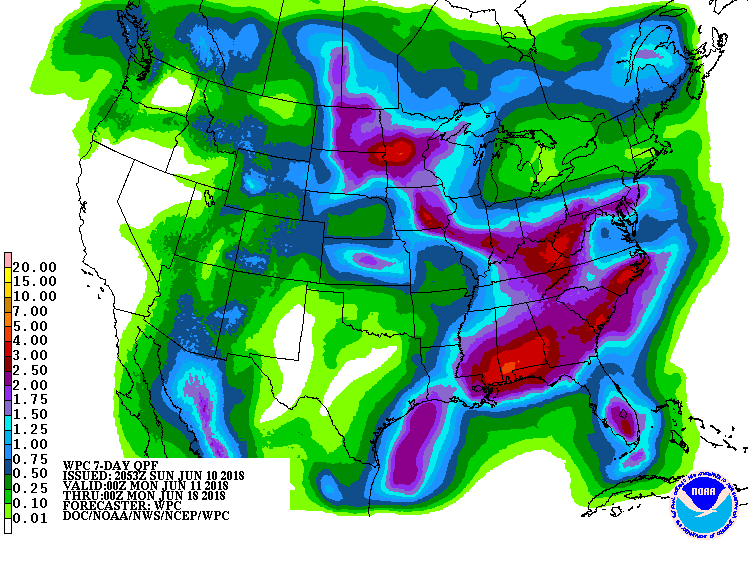 Scattered showers develop Saturday with .25”-.75” rain potential over 60% of the state as a minor front moves through. Lingering clouds and scattered moisture is in for Sunday too, although probably not amounting to more than few hundredths. Temps remain near normal for the weekend. The map above shows total precipitation for the next week.
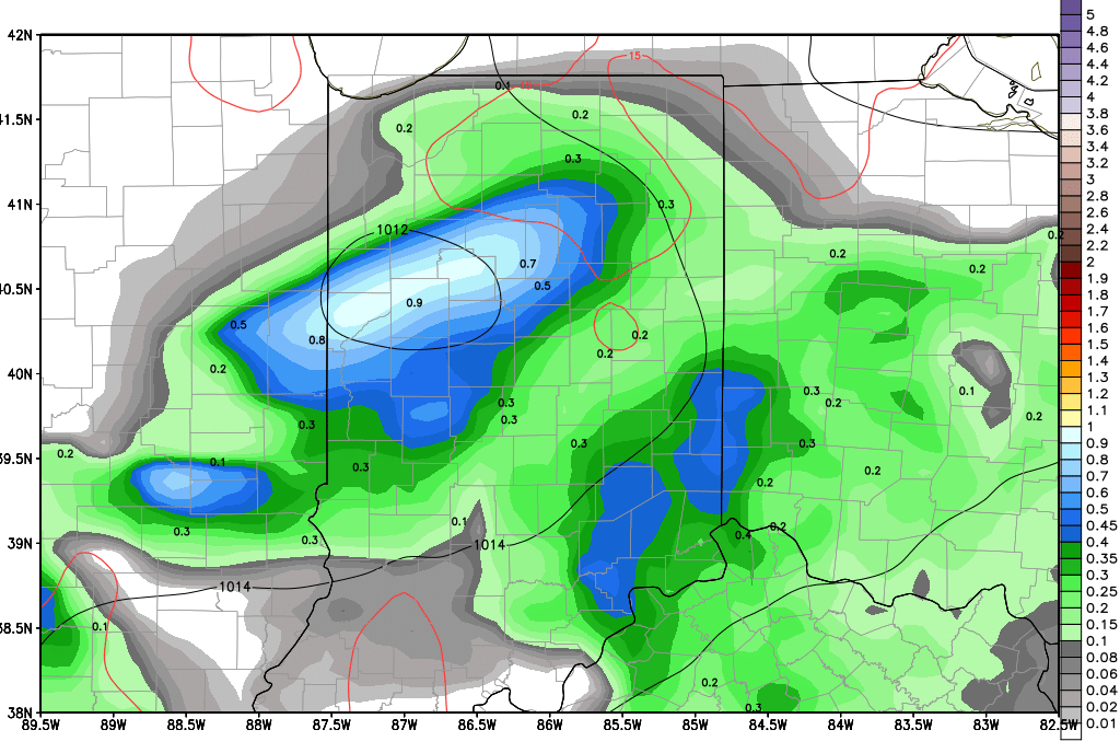
 So, today is the wet blanket on our week. Tomorrow, Thursday and Friday all look great. Sunny, dry, pleasant with low relative humidity and gradually warming temps. Then, there is today. We should be sunny, dry and pleasant, but instead, we are having to deal with clouds wrapping around a strong low off to the northeast and those clouds have the potential to drop a bit of precipitation on us too. We don’t like it. We think the pattern still is mostly dry, but we just can’t stand back and not acknowledge the pesky moisture that can be around. So, while we get through the day mostly dry, we can see a few hundredths to a tenth over about 40% of the state, and the bias here is the northern part of the state too. Timing can be any time this morning in the north, early to mid-afternoon central. Soutehrn Indiana should miss out on any moisture chance. We need to stress that there is not a lot of water to work with here. But, if there is something you truly don’t want wet today, cover it up (I did). The map shows precipitation totals through midnight tonight. These may actually be a little zealous on the top end, as we really like a tenth or less in most areas. But the coverage is very close to our thoughts.