Moisture is still around over the state today, providing a “long tail” to the weather system that started impacting the region over the weekend. A cold front will slowly sag southward over the state today, meaning the best precipitation will likely develop central and southern Indiana, but we will not rule out scattered showers up north either, especially this morning. Rains today can be from a few hundredths to a quarter inch up north, and .25”-.75” over central and southern Indiana. Coverage will be around 70% today.
The rest of the week may settle down just a little bit, but the pattern overall remains somewhat unsettled here. We think a strong high pressure dome will try and park over the Mid-Atlantic and Northeast states the rest of this week. Moisture will try and circulate around the bottom and backside of the high in clockwise fashion. This will keep plenty of moisture in over the Deep South and Tennessee valley, augmented by some flow up off of the Gulf of Mexico. This will also keep a chance of scattered, hit and miss showers in over the state through most of the rest of the week. We are not talking about significant rains like this past weekend, but more minor, pop up action from time to time. We do think we are looking at a slightly drier window for tomorrow and the first part of Wednesday, but even there, conditions will be right enough to trigger a bit of moisture here and there. Better rain chances are in for the second half of the week and weekend. With the damp feel and ample moisture, we can say that this week will not be one that features good dry down. In fact, drying will be tough and humidity levels high. As long as temps stay near normal (and they should…perhaps even a bit below normal in the near term), this forecast though is one that is very positive for crop growth and development for anything in the ground. Those who still have some acres to put in …this is not a forecast you are happy with. Forage and hay work this week will also be tough. Looking at the rest of the week (excluding today), we can see 70% of the state picking up another .1”-.5”. Coverage may be no better than 30-40% on any of the next few individual days, but combined we get to that 70% number.
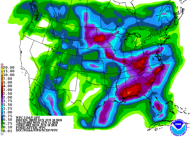 Scattered showers develop Saturday with .25”-.75” rain potential over 60% of the state as a minor front moves through. Lingering clouds and scattered moisture is in for Sunday too, although probably not amounting to more than few hundredths. Temps remain near normal for the weekend. The map above shows total precipitation for the next week.
Next week starts with no significant moisture or frontal action, but clouds are slow to leave. This set up looks similar to the second half of this week…where there is no significant synoptic event arriving, but we just are mired what seems like a soupy mess. We will keep Monday and Tuesday dry for now but look for scattered showers next Wednesday.
In the extended period, we have a front for late the 21st into the 22nd that brings .25”-1” of rain, and another front around the 26th that can bring equal rains. Both will end up with coverage around 80%.
Temps the next 10 days will be near normal. We can trend slightly below in the short term, and perhaps a bit above in the extended period.
