A mostly dry week ahead of us. Strong high pressure is working into the western Corn Belt out of the Great Plains. This high will keep dry weather top of mind for most of the week. Temperatures today will be near normal again, slightly warmer than yesterday. Winds should not be as strong. A big question mark hovers over tomorrow, however. We prefer a dry forecast solution and will run with that. However, several computer models are trying to bring minor moisture over the region tomorrow morning into midday. They source this moisture from a strong low circulating to the northeast, moving out of Ontario into Quebec. Now, we will admit this is a very strong low, but we think that the amount of moisture wrapping around the backside all the way back here is going to be minor. We should see some clouds to be sure. But, to get precipitation going…that is a completely different animal. Considering the dry nature that we currently find our atmospheric profile to have, we think it will be difficult. Even yesterday, we did not see any moisture materialize over Indiana generally, because the atmosphere was too dry, and that front had a better moisture set up than this wrap around. So, we are keeping our forecast dry with some morning clouds, but will say keep an eye on the sky as you start your Tuesday.
No matter if we stay dry or if Mother Nature does thumb her nose at me and bring a shower or two, we are dry to finish the week. Wednesday, Thursday and Friday all have plenty of sunshine, and a very dry set up. WE should see excellent drying potential for forage work, evaporation rates near maximum, and temps will slowly gain a couple of degrees per day. WE will be near normal for Wednesday, but slightly above normal for daytime highs by Friday. High pressure will generally be in control.
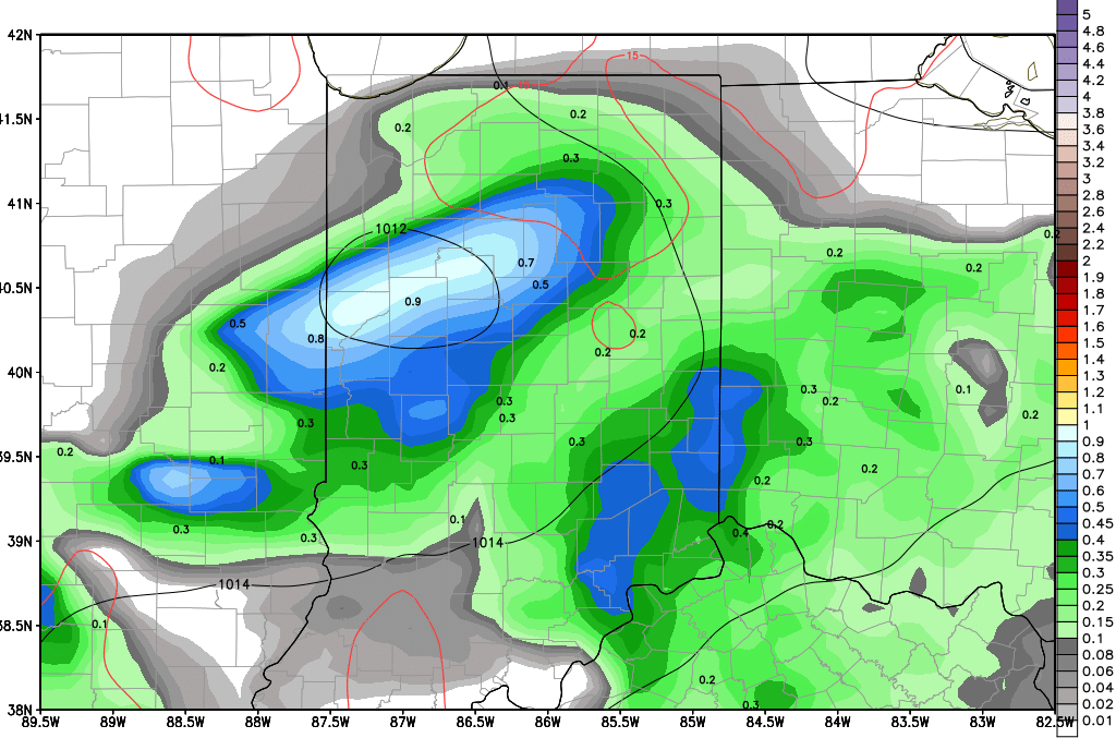
A strong frontal complex moves through for the weekend. Saturday we see rain and heavy thunderstorms br3eak out over northern Indiana, and then the action sags south through Saturday night and Sunday. Northern Indiana can see rain totals of .5”-1.5”, with the bulk of that coming on Saturday, while the southern half of Indiana sees rains of .25”-1” with most of that coming from Saturday overnight through Sunday early afternoon. Coverage of the entire event will end up being near 100% of the state. Thunderstorms Saturday in northern Indiana show characteristics of being strong, but it is way too early to call for any significant severe weather event…we are just on the lookout for some heavier rains. The map above is a snapshot from Saturday midday, with rain totals from the previous 6 hours. Notice the cluster of heavier rains oriented from just north of Lafayette, aiming toward NE Indiana…thunderstorms are behind this batch of heavier rain.
Dry behind this system to start next week, Monday and Tuesday. Temps will be near to a bit above normal, with good drying and low relative humidity. Our next front arrives for Wednesday and can bring .25”-1” rains to about 90% of Indiana. The front moves through quickly, and we should see most action done by sunset Wednesday. Dry for Thursday and Friday to start the 11-16 day forecast window.
A front arrives for next Saturday, the 16th. Rains can be from .1” to .8” with coverage at 60% of the state. Then strong high pressure moves in from the NW, and should keep the start of the week after next on the dry side. There could be another system threatening the region around the 21st into the 22nd.
So, in general, after this drier week, we move into a pattern that can be summed up with the term “timely rains”…so at this point, weather looks pretty good for crop growth and development.
