Indiana Weather Outlook 3-14-18

Drier weather settles in over the state starting today and it should hold through the end of the week. West winds today will be a bit brisk, but they will also allow temps to bounce a good 5-10 degrees over yesterday. WE should see temps in the lower to middle 40s for most of the period in the north, 50s in the south, while sunshine is the main component of the forecast today, tomorrow and Friday.

A little bit of a change in our forecast this morning for the weekend. On Saturday, we have a wave lifting up into Indiana that is part of a stronger system passing by to the south. This will bring clouds to a large part of the state, and a chance of rain from I-70 southward. Rain totals do not look to be too spectacular, but will register from a few hundredths up to a third of an inch. In northern Indiana we see no rain, just off shoot clouds. We are back to dry weather statewide for Sunday. Weekend temps are not that impressive, mostly near normal. Saturday would have potential to warm further, except for the clouds from the southern wave.

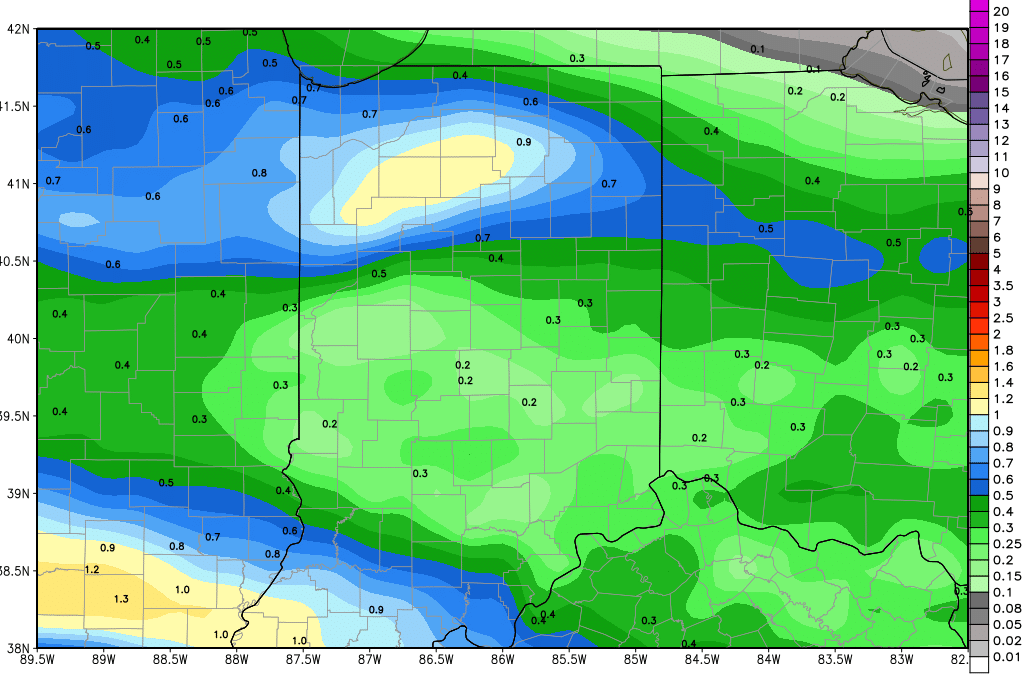
Our next strong low is on the way, but still looks to have most of its impact come late Monday through Tuesday. On Monday, we could see some strong south flow ahead of the low, bumping temps slightly. The best chance for warmth on Monday will be in southern Indiana, while we see less of a move up north. Clouds will be building through the day. Then when precipitation does break out later Monday night and/or Tuesday, we should see generally rain. We are keeping rain totals at .25” to .75” with coverage at 80%. We dry down late Tuesday afternoon and stay dry through the end of the week. The map below shows combined rains from the system Saturday and the system next Monday night and Tuesday.

gfs_precip_120hr_indy_30.png

Our next chance of well-organized precipitation comes for the 24th. A strong low exits the central plains, but its northern push is not as prominent. This means the low is tracking more toward the Ohio Valley. This would put 1-2 inches of rain into the Deep South, but would dramatically reduce action in the eastern Corn Belt. This bears watching. This track also is altering the later stages of the extended period. A front for the 27th now has low pressure staying north in Quebec, and the front slowly sagging south. This would bring slow moving, light rain to Indiana around the 27th through the 29th, but we may see rain totals at under .25” on any given day with coverage at 70%. The gulf is cut off in this scenario, meaning moisture is not nearly as impressive, but adds up. This is a period to watch, but looks less active than 24 hours ago.

Indiana Weather Outlook 3-13-18

Light snow and flurry action was a little more pesky and frequent yesterday than we would like to admit. And, unfortunately, strong north winds have only strengthened for today, meaning we can’t escape more of the same for today. The snow will definitely be enhanced by the lake, and will likely reach its zenith this morning into early afternoon. Later in the afternoon action will be pushing off to the east. We won’t rule out a fresh coating to half an inch on grassy surfaces, cars or anything else similar, but do not expect problems. Action will be limited to areas north of I-70, except we could see something south of Richmond in the eastern part of the state. All other areas south will just see clouds and cold air. Today should be the coldest day this week.

Winds turn west tomorrow, and that should swing us to more of a dry pattern. Those west winds all also allow for a slight moderation in temps, getting us closer to normal at midweek. We continue the dry pattern through the rest of the week and weekend. Temps will bounce into the lower to middle 40s for most of the period in the north, 50s in the south, while sunshine dominates.

Next Monday we see a bit of a transition day. Our next strong low is on the way, but may be delayed until late Monday night and then trigger most of its precipitation on Tuesday. So, on Monday, we could see some strong south flow ahead of the low, bumping temps slightly. The best chance for warmth on Monday will be in southern Indiana, while we see less of a move up north. Clouds will be building through the day. Then when precipitation does break out later Monday night and/or Tuesday, we should see generally rain. We like rain totals from .25” to .75” with coverage at 80%. That coverage is slightly less than 24 hours ago in our forecast due to the low tracking slightly farther north. We dry down late Tuesday afternoon and stay dry through the end of the week.

No change to our extended picture this morning. The next chance of well-organized precipitation comes for Sunday the 25th, with a strong low moving out of the central plains up into the Great Lakes. This will put us in the strong south flow part of the circulation, meaning temps should rise and we see the threats of .25”-1” rains, including some thunderstorms. Coverage will be nearly 90% of the state. The extended pattern stays active with another system a few days later for Tuesday the 27th. This system has a similar track and can bring .25”-.75” to 80% of the state. The heaviest rains out of that event split, with one tracking north into Michigan, and the other staying south of the Ohio River. We continue to expect that the month of March will finish with good precipitation chances.


Indiana Weather Outlook 3-12-18

The pattern remains mostly dry, but we do see more clouds invading the picture here over the next few days. Our next good chance of precipitation does not arrive until early next week, but this week will feature several trough passings and pesky cold air.


Today we see clouds slowly build as an upper level trough dips into the region after passing through the great lakes. This trough has very little useable moisture with it, but it will bring clouds and slightly colder air. If we see any precipitation threats it will be later this afternoon through tonight over the northern half of the state. However, moisture availability is limited to a few hundredths of an inch, meaning we can see a sprinkle or flurry later today north of I-70. Our gut feeling is that we see only some clouds. There will be nothing south.


As cold air tightens its grip on the state tomorrow, we have a second wave of minor moisture to deal with. We have to keep an eye out for a few spats of flurries across the state, but look for no accumulation. Clouds will be around through most of the day tomorrow, and temps will be below normal.


We are dry Wednesday, Thursday and Friday with sunshine returning. However, without strong south flow, we think temps will remain on the cooler side, mostly normal to below normal. The weekend looks dry now, with action Saturday staying south of most of the state, just like we saw yesterday. South flow will try and moderate temperatures just a little bit.


A strong low moves into the region next Monday into Tuesday, the 19th into the 20th. We see good rains with this system, and temperatures will be warm enough indeed for all rain. Totals will be from .25” to .75” with coverage at 100%. We dry down Tuesday afternoon and stay dry into the first half of the extended forecast window.


The next chance of well-organized precipitation comes for Sunday the 25th, with a strong low moving from the Oklahoma panhandle up into northern Michigan. This will put us in the strong south flow part of the circulation, meaning temps should rise and we see the threats of .25”-1” rains, including some thunderstorms. Coverage will be nearly 90% of the state. The extended pattern stays active with another system a few days later for Tuesday the 27th. This system has a similar track and can bring .25”-.75” to 80% of the state. The heaviest rains out of that event split, with one tracking north into Michigan, and the other staying south of the Ohio River. Still, it looks like we may finish March on a much more active note.


Temperatures over the next 10 days do not look like anything special…in fact we see mostly a cool bias through this week and weekend, and would expect mostly normal to below normal ranges into this coming weekend. This means we can’t quite seem to kick Old Man Winter out just yet.


Indiana Weather Outlook 3-9-18

A drier forecast pattern continues to move into the region. We have one more cold day here today, with temps below normal, but we should see more sun, as high pressure moves across the state. As winds turn south on the backside of the high, we should see temps moderate a bit over the weekend, moving to normal levels and even slightly above as we move into next week. A strong storm complex is moving over the Deep South and Tennessee Valley tomorrow, and we won’t rule out some clouds sneaking into SW Indiana through the day. Those clouds can trigger a few spits and sprinkles, but that is the only part of the state where we see any threat. The rest of us are sunny and dry.


Warmer air is in for Monday with strong southwest flow, but we have a minor trough sweeping through overnight Monday night through Tuesday. This trough has no significant moisture associated with it. However, colder air coming in behind the trough will cause clouds to become more prevalent into Tuesday and we can’t rule out a few spits and sprinkles due to the fact that colder air cannot hold as much moisture as warm air. Coverage will be very minor, and in reality, we think we stay dry in many areas. We just are not able to guarantee a fully dry day. Dry air does hold for the balance of the week next week, right on through Friday.


Next Saturday, a cold front moves in from the west, and will bring .25”-.75” rain potential to about 70% of the state. We are calling this kind of coverage because we see some significant holes potentially developing in the moisture as the front slides through. The front moves through the entire state, but precipitation will have some hit and miss characteristics. This will be the first well organized system in about 10 days, though, going back to what we saw earlier this week from Monday night through Wednesday.


In the extended period, another strong front around the 20th can bring rains of .5”-1.5” to 70% of the state. That system looks like it has a better track, better moisture availability and more strength than our front on the 17th, so we need to be on the lookout there. Still, by the 20th, we will mostly be below normal on cumulative march precipitation.