Scattered precipitation remains the focal point of our forecast this morning, but we do see some slightly bigger lulls in between waves. Overall, we are not changing the cloudy, gray, damp outlook we have been talking about for the coming 5 days.
Today we have scattered showers bringing .05”-.5” with 70% coverage. Action is mostly over the northern half to two thirds of the state this morning and midday, but will push south later this afternoon. Tomorrow may yield a bit more of a lull, but we won’t completely rule out some spits and sprinkles state wide. The best areas to see those will be far south near the Ohio River, where we can pick up few hundredths to no more than a tenth tomorrow. We see nothing up north.
More rain chances back for the weekend. Scattered showers will be in on Saturday, but perhaps not as intense as previously advertised. We make up for that by keeping the same kind of frequency, spread and intensity statewide for Sunday, and then the cold front comes through Sunday night. During the Saturday and Sunday period, we can see a few hundredths to .3”
with 60% coverage statewide each day. Then for Sunday night we have the front bringing .25”-1” rains to 80% of the state.
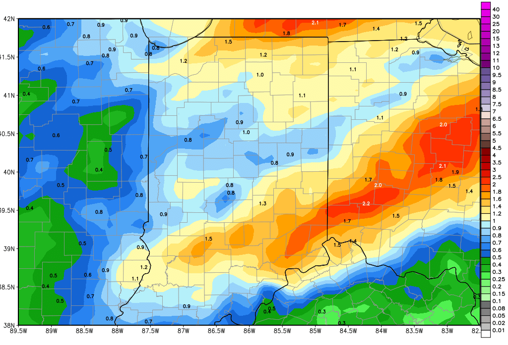
 Combined, we still like 5 day rain totals of .5”-1.25” over 80% of the state. The map above shows cumulative rain potential from today through Monday midday. Temperatures will be moving to above normal levels by late today, and will stay there through the weekend.
We begin to dry down Monday midday and afternoon. The entire state will then be dry for next Tuesday through at least Thursday. Temperatures will drop off substantially behind the front, and we look for temps to be mostly normal to below normal for the balance of the week next week. A System moving across the Deep South will try and throw some moisture up closer to the Ohio River valley late next week. Right now, we are keeping moisture out of the forecast for next Friday, but we see better clouds and may have to add some rain in our forecast tomorrow if current trends hold.
In the extended period, we look drier, with only 1 system in around the 16th, and minor rain potential of .25” or less.