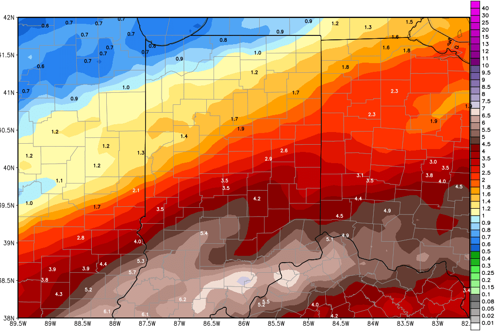
Dramatic changes in the forecast pattern will be working in this week. We are going to transition from the cold and snowy pattern that we saw for the first 11 days of February to a warm and wet pattern for the next 10 days. The map below is 10 day precipitation potential for the region. Time will tell if we swing back to a cold, snowy pattern for the last 6 days of the month, but it looks possible. Here is how it all starts to unfold.
Bitter cold air is in over a large part of the state this morning. Subzero temps are being reported over NW Indiana, but in general, the push below zero does not have quite as big of a geographical spread as we had been concerned about. We should see sunshine through the day today, and temps will start to moderate a bit this afternoon. By afternoon, we should see temps above freezing up to US 24.
Tomorrow, we see a further warming push, as sun is gradually replaced by clouds. A wave of moisture pushes by to the south late tomorrow afternoon, staying south of the Ohio River, but still it is able to push clouds and minor precipitation up into Indiana for overnight tomorrow night through Wednesday. We look for a few hundredths to a tenth or two with about 60% coverage. However we are looking at all rain, as temps continue to climb – Wednesday we should be in the 40s and 50s at least statewide.
Another, stronger wave comes in for Thursday. In fact…we see heavy rains in central and southern Indiana for later Thursday afternoon and overnight. 1-2 inch rains and thunderstorms are likely out of this event from SR 28 down to US 50. North and south of that area, we can see .25”-.75” rains in the same period. Keep in mind, the ground situation early this week is frozen, and even with 2 days of thawing, we still think rains of that magnitude will lead to some quick water accumulation and we may have to watch for some flooding. Moisture continues overnight Thursday into the first part of Friday, but should be moving away by early Friday afternoon. Colder air should be expected behind the front for Friday, with temps about 3-5 degrees below normal
Saturday should be dry with high pressure in place over SW Ohio, and we keep dry weather in for Sunday as well. Southwest winds for later Saturday and Sunday should put temps mostly back above normal.
We have a damp start to the week next week with scattered showers slowly moving through Monday, Tuesday and Wednesday. The rains have no more than a few hundredth to .25” on any given day, with daily coverage at 50% or less. But, combined through the period, we should see .25”-.5” rains and 80% coverage. Temps remain above normal.
Colder air comes in for the second half of next week with temps below normal. However, there is no precipitation in that colder push. A clipper for Sunday the 25th can bring some scattered snow, or perhaps some rain mixing with snow. The much stronger front is in for the 26th and 27th, bringing liquid equivalent precipitation of half to 1.5” over the entire state. Right now south flow ahead of that system would indicate rain potential, but the timing of the cold air arrival will be the key going forward.
