Very foggy over parts of the state this morning as we continue to see very mild air moving in over a cold surface. The worst fog is over northern Indiana where we are seeing significant snow melt put plenty of vapor into the air. Still, rain is on the way today, and it should dissipate the thickest fog just a bit. Rains today will be somewhat minor, as scattered showers develop from midday on through this afternoon and evening. Today’s totals look to be from a few hundredths up to perhaps half an inch. But, rains increase in intensity tonight, and there will be a band of heavy rains along and south of the I-70 corridor as we approach midnight. Rains continue into tomorrow morning, but will be ending north to south. After sunrise, we still see some showers from US 50 down to the river, but they will end by early afternoon. All told, today through tomorrow we see rain totals of half to 1.25” with coverage at 80% of the state. The remaining 20% of the state will see some rains, but may not make it to that half inch lower end of our general rain spectrum.
We dry down tomorrow afternoon and stay dry through Saturday. Cold air will be pushing in behind the system, allowing for some single digit lows Saturday morning over northern Indiana. However, that cold air does not stay, and the Canadian high bringing it moves quickly off to the east. That should allow south winds to develop Saturday afternoon and ramp up to rather breezy levels. Temps will rise with the help of the south wind.
Scattered light precipitation will sneak in overnight Saturday night into Sunday, but totals are not that impressive. We will look for a few hundredths to at most a quarter of an inch of rain in there, but coverage will be limited to 60% of the state. We do not like this set up that much, and think that a large part of the moisture may end up just hanging out as clouds, but it is something we need to watch for. Sunday afternoon we likely are done with action.
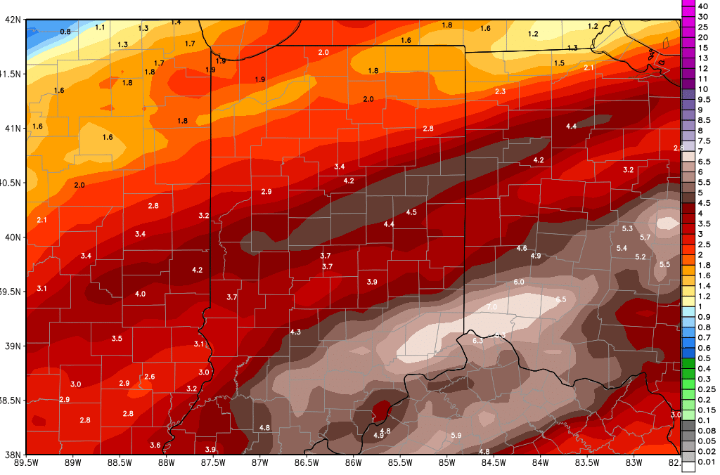
Next week looks very wet for Monday through Wednesday. We have rains of .25”-.5” on Monday, .25”-.5” Tuesday, and 1-2 inches for Wednesday. There can be some strong storms and very heavy rains in there at midweek. All told, rains for the first half of the week can be 1-3 inches. This will put the exclamation point on a wet 6 day period. The cumulative rain totals map (updated) is below for today through next Thursday morning. We do dry down some behind that last wave on Wednesday, allowing for 3 days precipitation free for Thursday, Friday and Saturday.
In the extended window, we still have chances for a couple of systems, but the one that stands out the most is a strong low pressure circulation that moves through at the end of the month, for the 28th and 1st. This low has ample moisture, a strong core, and plenty of temperature change to work with. WE see potential for half to 1.5” of liquid equivalent. March still looks like it wants to come in like a lion.
