Continued cold today. Northwest winds dominate the landscape, but we at least see a little less available moisture. Clouds will fight for space with sunshine, and we can’t rule out lingering wet snowflakes, mostly over the northern half to third of the state. However, temperatures today should be a couple degrees warmer than yesterday. Sunshine has a better chance at winning the war with clouds over southern Indiana.
Wednesday will be mostly dry statewide with a mix of clouds and sun. Clouds will be thickening up Wednesday afternoon as our next frontal complex draws close. South winds ahead of that system should take temps a little higher, closer to normal. This will, not be a significant warm up, though, and the moderation will be very short lived.
Moisture moves in tomorrow evening and then continues through Thursday. Available moisture is not all that impressive, but we draw our rain chances out over the entire period. We look for a few hundredths of an inch up to .25” with coverage at 60%. SW Indiana likely misses out along with areas near the Ohio River. All moisture is done by late Thursday afternoon.
We are keeping our forecast dry for the Friday, Saturday and Sunday time period and are also looking to add Monday to this. The system coming up from the southwest does not look as impressive for early next week. Temps stay cool through the weekend, and will start to moderate just a bit on Monday, as south flow starts to develop ahead of that SW circulation.
We our pushing that next system back into Tuesday, reducing its footprint and its rain potential this morning. In fact, there is a good chance that we escape the first part of the week with no precipitation in Indiana, short of a few scattered showers near the Ohio River. This system is waiting until it gets farther east into OH before it shoots north. Now, that means we still have to watch this event, as any slowing or strengthening could adjust that track back into our area. But, at the moment, it looks like we can catch a break and get through the period with little action, and we may actually be able to put together a significant string of dry days over a large part of the state, particularly up north. AT this time, temps look to stay cool, though, so we will not dry down quite as fast as we otherwise could, and soil temps will not move all that fast. But, it is an improvement over previous forecasts.
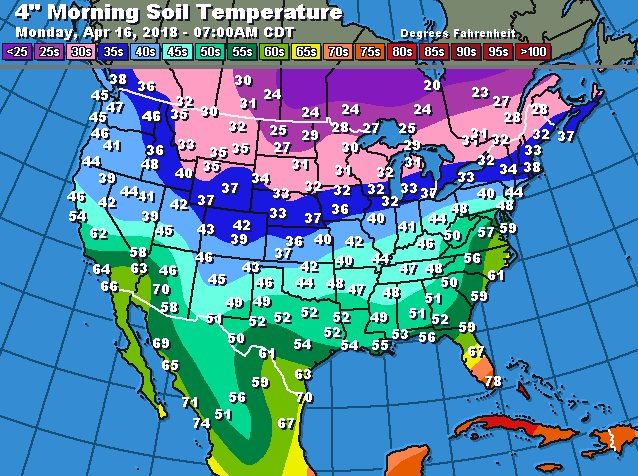
Strong Canadian high pressure slides into the region at midweek next week, meaning we see a reinforcing shot of cooler air spreading across the eastern Corn Belt. This high promotes dry weather. So, if we miss out on action next Tuesday, there is potential that we are dry from this Thursday right on through next Friday, the 27th. This will be watched very closely. Then, a cold front works in from the northwest for the 28th and moisture associated with that stalling front can hold through the 1st. As precipitation dissipates for the 2nd, we should see high pressure settle in over the Great Lakes for a couple of days, before another system lifts out of the central and southern plains around May 4th. While we have a few attempts by our atmosphere to moderate between now and months end. For the most part we average 5-15 degrees below normal for the rest of April on the whole. That means soil temperatures will be slower to move…although they will be moving upward. Below is a map of soil temperatures from yesterday. We have some work to do!