Warm air continues to surge north across the state today. Temperatures will be a good 10-15 degrees above normal, fueled by strong south winds averaging 15-30 mph. However, clouds will be on the increase today, as we get closer to moisture from our approaching frontal boundary. That moisture should hold off in most places until tomorrow.
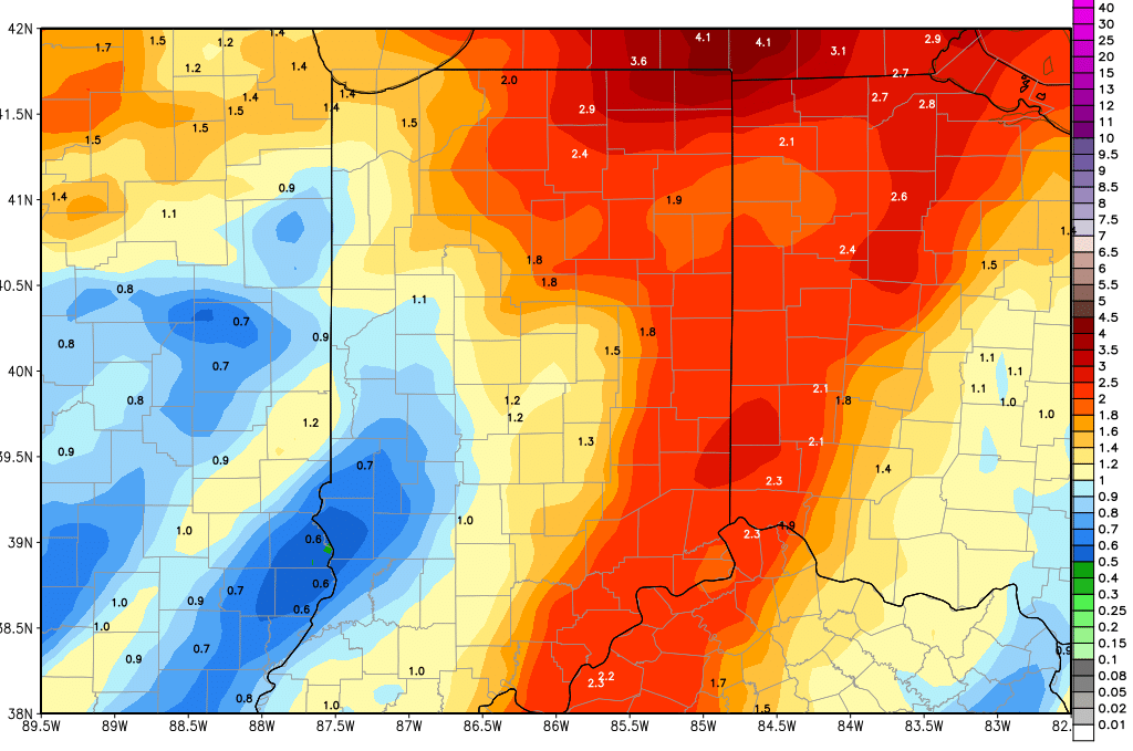 Significant rains are here for the weekend. Saturday and Sunday we have combined rain totals of .5”-2” with coverage at 90% of the state. To get into the upper part of the range, you will need to have a few stronger thunderstorms, but there is a fairly good strong to severe weather threat for tomorrow afternoon and evening, along with mid to late morning on Sunday. Rains will come and go tomorrow, and we expect some significant holes in the coverage to be seen through mid-afternoon. But, then things fill in a lot more, the closer we get to the cold front itself. Behind the front, significantly colder air blasts in Sunday afternoon and evening. In fact, we expect lingering moisture to change over to and end as some sloppy wet snow Sunday night, and we can’t rule out on and off wet snow for Monday. STrong northwest winds will be at 15-30 mph overnight Sunday night and Monday, and temps will be back to 10-12 degrees below normal at least, perhaps 15 degrees below normal in spots. The map above shows total precipitation through Monday morning.
While clouds and cold air dominate Monday, we should see better chances for sunshine Tuesday, but it stays cool.
The cool air holds through most of the rest of the week. AT midweek on Wednesday we have a light rain back in the forecast, with showers over northern Indiana that produce up to .25” of liquid. We do expect rain, not snow from this event. South of I-70, we see nothing, and may even see some sunshine. We are dry to finish the week.
At the end of the 10 day period, we have our next front arriving for the 22nd with rains of half to 1.25” For the extended 11-16 day window, we have 2 more systems, one on the 25th with .25”-1” rains, and finally, a strong low coming out of the plains for the 28th with .5”- 1” rains. Coverage from all three systems will be around 70% to 80% of the state. This forecast, as it currently sits, continues to have not quite enough dryness in-between systems to see significant field work through the end of April.
