Dry through the next 3 days. We see sunshine, blue sky and temperatures slowly climbing as south winds return. WE should see good drying and good evaporation through the period.
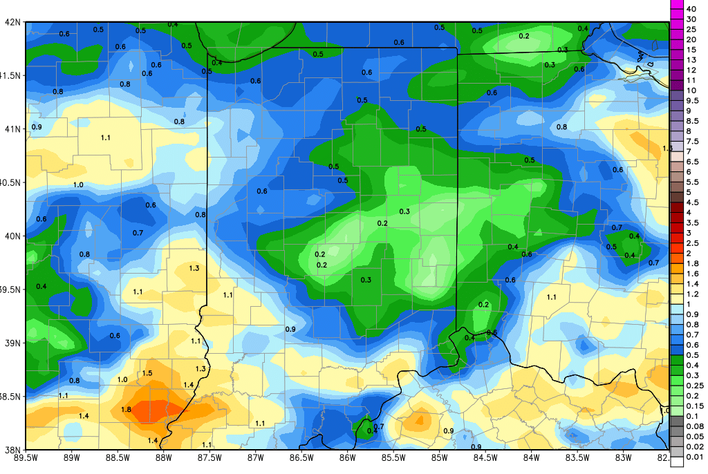
Clouds return Wednesday afternoon and precipitation breaks out Wednesday night. Rain and thunderstorms will be at their zenith from just ahead of midnight Wednesday through Thursday sunrise. Rain totals look to be from .25”-1” with coverage at 80% of the state. By Thursday afternoon, rain is done in most of the state. Friday and Saturday will be dry from US 24 southward. However, the northern third of the state will see lingering cloud cover through at least Friday and perhaps Saturday. We think precipitation stays mostly up over MI, but the long and short of it is that we can’t completely get rid of a chance of showers those days up north, and drying will be limited. Friday in particular we can see a few hundredths to .25” of moisture over about 80% of the state north of SR 26. The map shows rain totals through Saturday morning.
Heavy rain and thunderstorms are in for Sunday, and linger though Monday midday. WE can see rains from half to 1.5” with strong to severe thunderstorm potential. 100% coverage of rain out of this event. The strong thunderstorms look to be most active in central and southern Indiana from midnight Sunday night through Monday morning. All action is done by Monday afternoon.
Dry weather is back for Tuesday and Wednesday. Our next front likely develops later in the extended 11-16 day forecast window. A cold front sweeps through around the 20th bringing rains of half to 1.5” over 90% of the state. A reinforcing wave of energy brings additional rains up to 2” for late the 21st through the 22nd.
Temperatures this week will be normal to above normal, with the warmest air coming in ahead of the front on Wednesday. This weekend though will feature good strong south flow funneling warm air in to the Sunday event. Basically we see no cold air outbreaks in the next 2 weeks.
