Sunny, dry and warm today. Sunny and warm tomorrow. Temps above normal
Clouds return tomorrow afternoon and precipitation breaks out tomorrow evening. Rain and thunderstorms move into NW, north central and west central Indiana near or after sunset, and action spreads south and east. There seems to be less of a threat of thunderstorms now, but until we see how the heat starts to interact with the front tomorrow, we will not be able to wave the all clear flag just yet. For now, we will leave rain totals tomorrow night through midday Thursday at .25”-1” with coverage at 80% of the state. Many areas will be at a half inch or less. By Thursday afternoon, rain is done in most of the state. We continue to see a secondary wave moving across the Upper Midwest into the great lakes for Friday and Saturday. That will leave the chance of scattered showers in over northern Indiana, from the Michigan line down to US 24, or at the very least plenty of clouds. Farther south, we have nothing going on for either day, Saturday or Sunday. If showers do pop up to the north, a few hundredths to a tenth or two will be all we are looking for.
Heavy rain and thunderstorms are in for Sunday, and linger though Monday midday. WE can see rains from half to 1.5” with strong to severe thunderstorm potential. 100% coverage of rain out of this event. The strong thunderstorms look to be most active in central and southern Indiana from midnight Sunday night through Monday morning. All action is done by Monday afternoon.
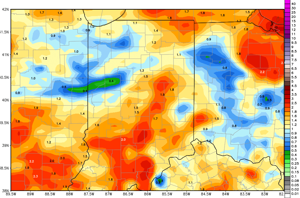
Dry weather is back for Tuesday and Wednesday. A weak frontal boundary lifts up from the southwest for Thursday the 17th, bringing .1”-.4” to about 60% of the state. The best coverage will be in southern and central Indiana. The map above shows total rains through the next 10 days. The bulk of this comes tomorrow night through Thursday and then Sunday night into Monday.
Going into the extended 11-16 day forecast window, we have a stronger cold front sweeping into the state closer to the 20th bringing rains of half to 1.5” over 90% of the state, and then a reinforcing wave of energy brings additional rains up to 2” for late the 21st through the 22nd.
Temperatures the second half of this week will pull back closer to normal, and then move slightly above normal levels heading into next week again, before that front develops on Thursday. We do expect a significant temperature correction behind the strong thunderstorms that are possible later this Sunday.
