Author: weatherstud

Indiana Weather Outlook 2-14-18

We are going to need to keep the umbrella, galoshes, and floatation tires at the ready over the next 10 days. We are going to swing quickly from cold and snowy to mild and very, very wet. In addition to massive snow melt in northern Indiana, we see several strong waves of moisture moving through for the period, and they can dump plentiful moisture.

Starting things off, a relatively minor wave of moisture started working into areas south of the Ohio River late yesterday and threw a lot of clouds up across the state. We will see scattered showers off and on today, as temps warm. Snow on the ground over the northern quarter of the state will act as a bit of a refrigerator, but we still expect a mild day, and plenty of snow melt there. Rain totals will be a few hundredths to a quarter of an inch, with coverage at 50% or less.

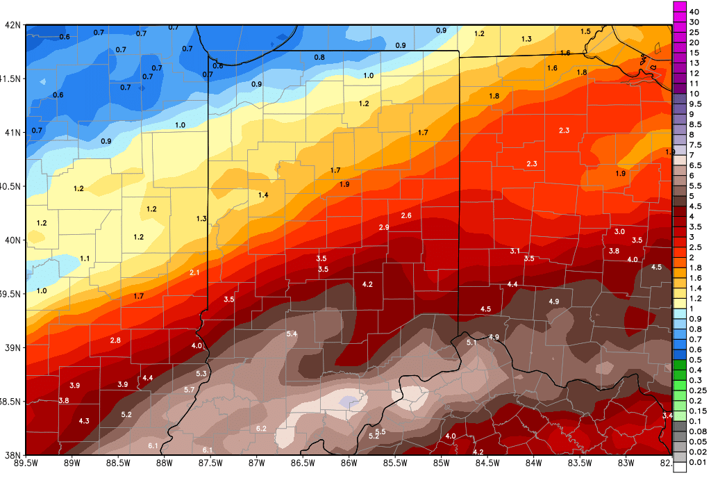
A second wave of action pushes in from the north and west tomorrow evening and through Friday. WE continue to see significant moisture with this front, and it will hit nearly all of the state. We are keeping our general rain totals at 1-2 inches, and if an area fails to get to that range, you still can see .25”-1” there. The 1-2 inch range should hit 75% of the state. Action will be done by late Friday night, and colder air comes in for about 12 hours.

Temps bounce right back for Saturday afternoon. We won’t be as warm as the prior few days, but still should be above normal. The main hiccup in our weekend is the potential for scattered action to return late Saturday night into Sunday. We don’t think this is exceptionally likely at this stage, but we will watch it and make changes to the forecast tomorrow if we get some confirming data.

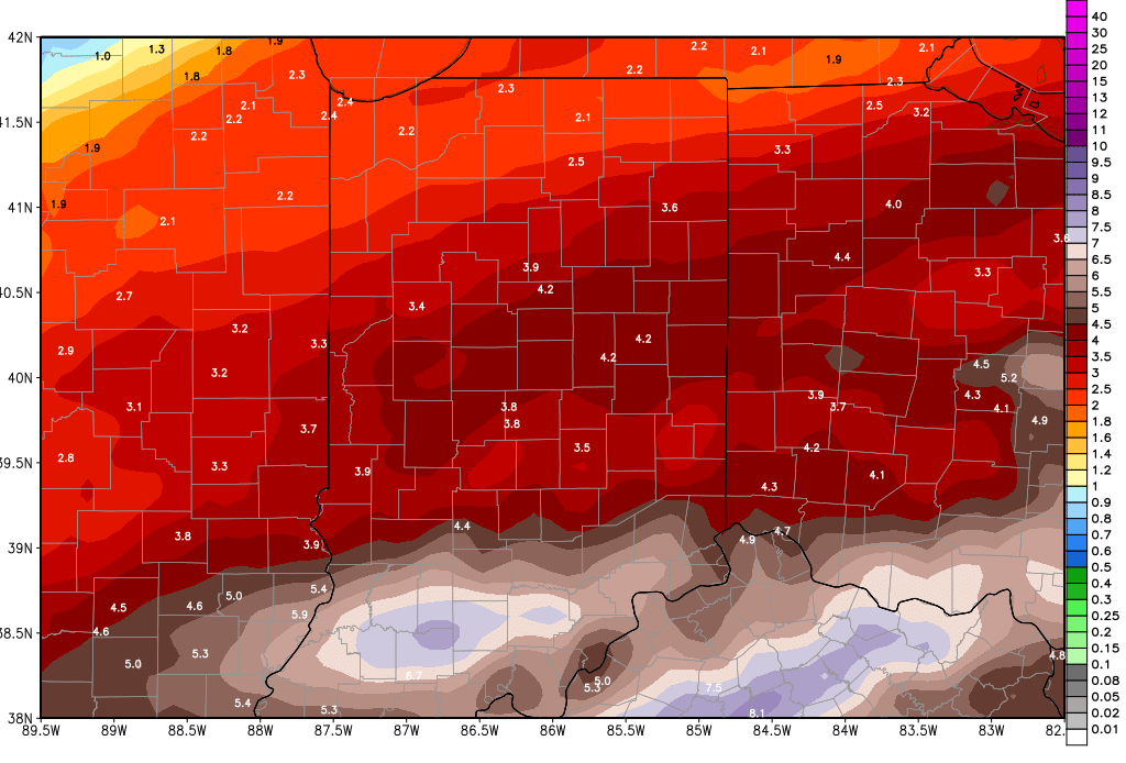
With or without Sunday moisture, next week still looks very wet. Rains come Monday, Tuesday Wednesday and early Thursday. Combined totals for that period could be 1.5-3”! That does not include what we see in a few days here. So, localized flooding, standing water, and a greasy mess are all in our forecast between now and the end of next week. The map below shows a potential cumulative rain moisture total from now all the way through next Thursday.

gfs_tprecip_indy_412.png

In the extended period, we are watching for our next system around the 25th. We are not sure that air gets cold enough quick enough to call this a true clipper. However, we do look for colder air later in the month, with a strong system crossing the eastern Corn Belt between the 27th and the 1st. This storm right now looks to focus a bit farther south, over southern Indiana and south of the Ohio River. But, there is plenty of time for it to lift northward. An even bigger system comes out of the plains for the 2nd, meaning march appears to want to come in like a lion!

Indiana Weather Outlook 2-13-18

No significant changes in our forecast this morning. Temps today should be a little better than yesterday, but we are waiting until we get into tomorrow to see large jumps in our high temps. Today, we should just be getting back near normal for this time of year. Southwest winds develop through this afternoon, and that gives a signal that this warm up is just beginning. Clouds will likely start to develop later this afternoon and tonight. Above normal temps will be seen tomorrow, and we have to keep an eye out for some minor precipitation. We won’t rule out a few scattered showers over the state, particularly late tomorrow afternoon and tomorrow night. Rain totals will be a few hundredths to .4” with coverage at 70% of the state.

A second wave of action pushes in from the west and southwest Thursday afternoon and evening and goes through Friday. This will be where we see more significant moisture. We are looking for half to 1.5 inch rains from over 90% of the state from Thursday afternoon through Friday early afternoon. While we do not have as big of concern about thunderstorms, this will still be an impressive batch of water, and we still think that there is potential for localized flooding, particularly in areas with significant snow melt and frozen ground as of today. The focal point for the heaviest rains has shifted this morning a little farther east. Ohio may actually end up wetter than we do here in Indiana

Much colder air comes in behind that system to start the weekend. However, it does not last long term. A cold night is expected Friday night, leading to a chilly start on Saturday. But, west and southwest winds are back in the state by midday Saturday, and we should see temps move back to near normal levels for Saturday and above normal levels then for Sunday. We will be dry through the entire weekend.

gfs_tprecip_indy_411.pngNext week is damp, with scattered showers likely from overnight Sunday night through next Friday. Several waves of light moisture will move through. While Ohio may be on the hook for the heavier rains later this week, we look to take the brunt of next week’s rains in Indiana. Rains overnight Sunday night into Monday can bring .3”-1.25” over 100% of the state. Then, after a slight, cloudy lull overnight Monday night through the first part of Tuesday, we have heavy rains back for Tuesday night through Wednesday. WE can see rains easily of 1-2”, and locally higher amounts over the northern half of the state are likely. This also has the potential to trigger some significant flooding, especially up north, where significant snow melt will either be underway at the time, or will be nearly finished, saturating a partially frozen soil profile. Temps will be mostly above normal all of next week, leading to increased rain potential. This is a wet upcoming pattern. The 10 day cumulative rain totals map is updated above. Much colder air comes in behind that frontal boundary for late in the week, Thursday and Friday.

In the extended period, we likely see a clipper for Sunday the 25th. That fast moving system can bring some scattered snow, or perhaps some rain mixing with snow. The much stronger front remains targeted for the 26th and 27th, bringing liquid equivalent precipitation of half to 1.5” over the entire state. Right now south flow ahead of that system would indicate rain potential, but the timing of the cold air arrival will be the key going forward.

Indiana Weather Outlook 2-12-18

Dramatic changes in the forecast pattern will be working in this week. We are going to transition from the cold and snowy pattern that we saw for the first 11 days of February to a warm and wet pattern for the next 10 days. The map below is 10 day precipitation potential for the region. Time will tell if we swing back to a cold, snowy pattern for the last 6 days of the month, but it looks possible. Here is how it all starts to unfold.

gfs_tprecip_indy_41.png

Bitter cold air is in over a large part of the state this morning. Subzero temps are being reported over NW Indiana, but in general, the push below zero does not have quite as big of a geographical spread as we had been concerned about. We should see sunshine through the day today, and temps will start to moderate a bit this afternoon. By afternoon, we should see temps above freezing up to US 24.

Tomorrow, we see a further warming push, as sun is gradually replaced by clouds. A wave of moisture pushes by to the south late tomorrow afternoon, staying south of the Ohio River, but still it is able to push clouds and minor precipitation up into Indiana for overnight tomorrow night through Wednesday. We look for a few hundredths to a tenth or two with about 60% coverage. However we are looking at all rain, as temps continue to climb – Wednesday we should be in the 40s and 50s at least statewide.

Another, stronger wave comes in for Thursday. In fact…we see heavy rains in central and southern Indiana for later Thursday afternoon and overnight. 1-2 inch rains and thunderstorms are likely out of this event from SR 28 down to US 50. North and south of that area, we can see .25”-.75” rains in the same period. Keep in mind, the ground situation early this week is frozen, and even with 2 days of thawing, we still think rains of that magnitude will lead to some quick water accumulation and we may have to watch for some flooding. Moisture continues overnight Thursday into the first part of Friday, but should be moving away by early Friday afternoon. Colder air should be expected behind the front for Friday, with temps about 3-5 degrees below normal

Saturday should be dry with high pressure in place over SW Ohio, and we keep dry weather in for Sunday as well. Southwest winds for later Saturday and Sunday should put temps mostly back above normal.

We have a damp start to the week next week with scattered showers slowly moving through Monday, Tuesday and Wednesday. The rains have no more than a few hundredth to .25” on any given day, with daily coverage at 50% or less. But, combined through the period, we should see .25”-.5” rains and 80% coverage. Temps remain above normal.

Colder air comes in for the second half of next week with temps below normal. However, there is no precipitation in that colder push. A clipper for Sunday the 25th can bring some scattered snow, or perhaps some rain mixing with snow. The much stronger front is in for the 26th and 27th, bringing liquid equivalent precipitation of half to 1.5” over the entire state. Right now south flow ahead of that system would indicate rain potential, but the timing of the cold air arrival will be the key going forward.


Indiana Weather Outlook 2-9-18

Two dramatically different forecasts this Friday morning over Indiana, depending on where you are. Over the northern third of the state, snow is falling and will fall all day. The southern extent of the snow will be roughly the US 24 corridor. South of there, we see some clouds, and south of I-70, we likely see sunshine off and on through the day. Up north, snows of 1-3 inches are likely from US 24 up to near SR 14, and then 3-8 inches from SR 14 up through SR 4. There is potential for some 10” plus snows in far northern Indiana, but we feel those are not going to be as widespread as some other forecasts have advertised. There is still a major discrepancy between models, and we are not going to take the most zealous model and run with it at this point. Many of the heaviest snow areas will see between 5 and 8 inches, from US 30 up through SR 4. The snow will continue all day in the north, finally tapering off after near evening. Again, farther south we see nothing, and many areas south of US 24 will be able to see afternoon highs today at or above freezing! That means this snow up north will be of the heavy, wet variety, which also weighs on our forecasts this morning. The map below shows snow accumulations through early tomorrow (Saturday) morning.

gfs_6hr_snow_acc_indy_8

We are not done with snow after this. In fact, we have a cold front that sweeps through tomorrow and Sunday that can bring an additional 1-4” to 80% of the state. This front brings in much colder air to the south, and should leave snow accumulations all the way down to the Ohio River. The biggest snow totals will run from central IN up through northeast IN.

Bitter cold air is still on the way behind that frontal complex. We expect to wake up to subzero temps over almost all of the northern half of the state Monday morning. South of I-70, temps will also be chilly, but should remain in the single digits to low teens. Sunshine will dominate as we move through Monday. After the cold start to the week, we have temps moderate a bit Tuesday, before clouds and colder air returns for Wednesday. High pressure dominates next Thursday and temps climb again on Friday. We do have some scattered light snow showers possible overnight Friday night into early Saturday, mostly over the northeast quarter of the state. On Saturday, we turn colder and drier again. After the very active pattern of this past week to 10 days, next week will seem downright boring.

We see no change to the extended pattern, and expect it to turn more active again. Right now we are eyeing 3 systems in 5 days. One on the 18th brings rain mixed with snow, and liquid equivalent precipitation of a quarter to half inch. On the 20th we see half to 1 inch of moisture coming through (liquid equivalent) and on the 21st we can see 1-2 inches of liquid, potentially coming as mostly snow. We should end the 11-16 day period with dry and cold weather through the 24th.