Author: weatherstud

Indiana Weather Outlook 11-17-17

hires_tprecip_indy_61.pngTemperatures will moderate today, especially this afternoon, as south winds develop across the state. Clouds will be thickening through the day, but rains likely hold off until late this afternoon and more so this evening. We see the rains picking up intensity overnight and through the day tomorrow. We are leaving rain totals at .25”-1” over 100% of the state from tonight through about 4 am Sunday morning. The map shows cumulative precipitation for this event through sunrise Sunday.

We turn colder for Sunday with strong northwest winds coming in behind the frontal complex. While we cant promise full sun on Sunday (clouds likely linger in the wake of the front, at least a little bit), we can say it will be dry through the day, and that dry pattern holds all the way through next Saturday. Temperatures will be bouncing all over the place in that period, staying below normal for Monday, but moderating Tuesday to near and slightly above normal levels. Cold air returns for Wednesday and most of Thursday, but we are making a change in our temperature forecast from there. Temps begin to moderate again late Thursday (thanksgiving) evening and will warm to above normal levels to finish the week and weekend. The cold Canadian air that was projected to hold through the holiday weekend has weakened and will be pushed back farther north.

Scattered showers are in for next Sunday, the 26th. We see .1” to .4” rain totals over 80% of the state.

In the extended period, we continue to see mostly dry weather for the 27th through the 30th. Our next frontal boundary starts to impact the state around the 1st of December. Precipitation totals remain unimpressive, so we will stay at .25” or less.

Indiana Weather Outlook 11-16-17

Dry weather expected over the state today and colder air spills into the region on northwest flow behind the front that moved through yesterday.

Clouds return to the state tomorrow ahead of a strong front coming in to finish the week and start the weekend. Scattered showers start up tomorrow afternoon and will be most frequent north of I-70. We see warmer air surging back into the region with the moisture. Rains increase overnight tomorrow night through Saturday working south and east across the state with some thunderstorms still possible. The best chance for thunderstorms looks to be central Indiana Saturday midday and afternoon, although we don’t want to try and finesse the forecast too much at this time. Rains finally diminish after midnight Saturday night. Rain totals for the event will be from .25”-1” over 100% of the state.

Clouds hold for a good part of Sunday again, as northwest winds return. We will be colder. Clouds may be able to break for some sun later in the day, but we have low expectations at this point. We then have dry weather for the rest of the week as well, Monday through the following Saturday. However, temperatures for this dry period are going to be all over the place. We stay relatively cold on Monday, then see moderating temps Tuesday. A strong Canadian high dives in for Wednesday, Thursday and Friday, taking temps back below normal again, before we moderate for next Saturday. So, it will be a roller coaster ride, even though we expect some good sun through the period.

In the extended period, we see a nice front pushing in for Sunday the 26th. The heart of this system will pass by to the south, but we see some moisture able to surge north over the state. This can bring .1”-.5” with coverage at 70%. Then we are dry for the 27th through the 30th. We have another cold front lining up for December 1st, but precipitation totals do not look too impressive at this time, perhaps a .25” or less. However, precipitation could be either rain or wet snow. Stay tuned.

Indiana Weather Outlook 11-15-17

Clouds are here and we will see some minor rains move through the state today. This cool front will bring .1”-.5” rains to roughly 80% of the state. The best rains will be midday through afternoon and should be winding down by sunset. Breezy conditions are in tomorrow behind this little system, but we may not be able to see full sunshine. We have concern that clouds hold thanks to strong NW flow into the state. But, we at least get by with no new precipitation tomorrow.

gfs_tprecip_indy_19.png
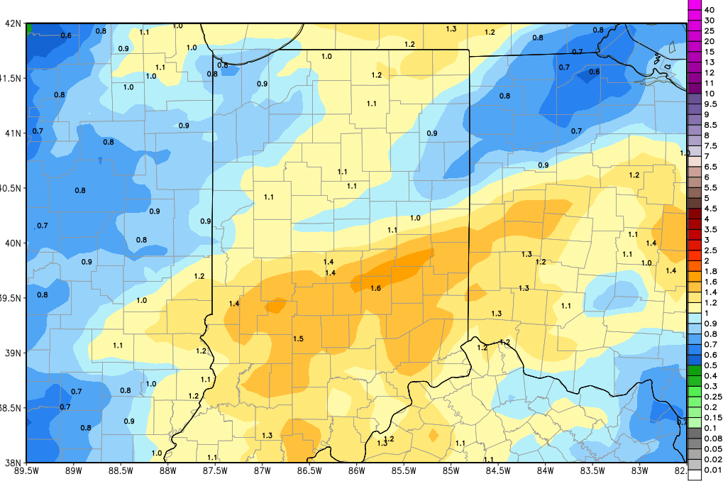
A stronger front is on the way for the weekend and clouds build Friday morning. Scattered, light precipitation breaks out by midday over parts of Indiana, and will focus mostly on the northern half of the state. Heavier rains move in overnight through the first half of Saturday. The threat of thunderstorms is smaller again, but we do think we can see heavier rains out of this event. Right now, we are leaving rain totals at .25”-.75” over 100% of the state, but are leaving the door open to some 1” totals on a localized basis.  The map above shows combined rains today through the weekend.

Drier for Sunday and Monday, as we have been looking for over the past few forecasts. However, we do have some changes for next week. The next system we had been projecting for next Tuesday has dissipated. In fact, moisture looks to get locked up to the south over the Lower Mississippi valley at midweek. So, we stay dry for Tuesday right on through the balance of the week. But, it comes at a cost. Cold air looks more impressive now for Thanksgiving Day and on through the balance of the holiday weekend. A strong surface high comes out of Canada and parks right on top of the eastern US. This keeps moisture locked up well to the south, but puts temps below normal right on through the holiday weekend.

In the extended period, we may see some of that moisture from the Deep South move into the OH valley late next Sunday as the cold core high starts to move off to the north and east. That looks to allow a more active pattern to gain ground again, with rains developing around Thursday the 30th. The rains will be under a half an inch and will favor the southern part of the state if things play out as we see them right now.

Overall, the biggest headlines this morning are the potential for heavy rain still this weekend, drier weather next week, and a cold push for the holiday weekend.

gfs_tprecip_indy_19.png

Indiana Weather Outlook 11-14-17

No change in our pattern this morning. We still see 3 systems moving through the state over the coming 10 days. However, today should be better than yesterday, as we should have better potential for sunshine. High pressure is moving off to the east, and south winds will allow clouds to break up.

A front moves into the area tomorrow and brings some minor rains with it. We are keeping our rain totals at .1”-.5” over 70% of the state from tomorrow mid-morning through sunset. That coverage number is slightly smaller than our previous forecast. The rains look fairly gentle and low key.

A slight pause brings dry weather for Thursday, but clouds likely hold on thanks to colder air pushing in. Our next system is moving a little faster, and may start to bring rains as soon as Friday midday. This faster arrival is another reason we are skeptical that we see any significant sun for Thursday. Rains continue for Friday afternoon and most of Saturday. The threat of thunderstorms does not look as strong this morning, thanks to less heating and instability. Still, we are looking for some fairly good rain totals over time. From Friday midday through sunset Saturday we still look for .25”-.75” over 90% of the state – which takes just a little bit off the top end of our previous rain range, and backs coverage off ever so slightly.

The weekend system arriving a little sooner means we are drier a bit sooner as well. We stay dry for Sunday and Monday, but think that we have a better chance for sun by Sunday midday. High pressure will move through, and colder air will be here. The winds to not look as strong for Sunday, but can still be brisk.

Moisture is back for next Tuesday as another quick moving system comes in from the west and southwest. Rain totals are not overly impressive, but can give us a few hundredths to as much as .4” over 70% of the state. This system will be more looked at for the air mass it leads in. We expect a nice push of cold, Canadian air to move into the region for Wednesday and Thanksgiving Day. Temps likely move to below normal levels at midweek and stay there through the holiday weekend.

In the extended period, we are starting to trend just a little drier on the whole, mostly due to the cold Canadian air that wants to camp over the eastern US. The upper level high steers most systems by to the north or erodes the small moisture content that tries to nose in. At this point, we will keep an eye out for a few flurries around the 24th into the 25th, but those are not likely a big story. A bigger story may be our first look at some lake effect snow in northern parts of the state, with strong winds coming straight down the fetch of lake Michigan. Now, that is not a large system, and therefore we can say the pattern is drier, but it is news for our northern and NW IN communities. Its way too early to really jump in with both feet on a lake effect projection, but since it’s a holiday weekend, we will be keeping a close eye on it. The rest of the state and the rest of the extended period look to be uneventful.