Author: weatherstud

Indiana Weather Outlook 11-13-17

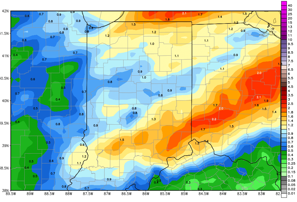
An active pattern over the next 10 days will allow no more than 2 to 3 days of dry weather in-between weather systems. Temps near normal mean we do not expect groundbreaking drying with those periods either. That being said, only one of the next 4 weather events looks to promote excessive rains, and we have no snow chances coming. The map below shows cumulative rain totals from the next 3 systems over the coming 10 days. We outline these below.

We have high pressure moving over the state today behind that weak low that brought the on and off rains yesterday. This high will bring cooler air today, even with sunshine, but on the backside tomorrow, south winds should allow for some minor moderation. However, our thoughts from last week of temps potentially getting above normal are long gone, and a move back to normal will be about all we can do. Either way, sun the next two days will feel better than the dreary close to the weekend.

gfs_tprecip_indy_41Our next system arrives Wednesday and will bring some moisture with it. The cold front drops .1”-.5” over about 80% of the state from Wednesday mid-morning on through sunset. These rains do not look overly intense, and will be similar to recent rains we have seen. We are back to dry weather with some sunshine for Thursday.

A stronger frontal complex arrives for the start of the weekend. Clouds will be building through the day Friday, and rains could start to overspread the state Friday night. They will be light at first, with only a few hundredths to a tenth or two for Friday late afternoon and evening up to midnight. But much heavier rains come as the low pressure center comes close overnight Friday night through the first half of Saturday. That could actually trigger some stronger thunderstorms for Saturday, and will be where the heaviest rains come. All told, from sunset Friday night through sunset Saturday we can expect .25”-1” over 100% of the state. This will be a significant rain event and will lead to likely delays through the next rain event.

We go dry for Sunday and Monday, although Sunday we may be stuck with some lingering clouds over a large part of the state. Colder air comes in behind that system on strong northwest winds, and the coldest day will be Sunday.

Next Tuesday, another fast moving low tracks across the state, coming in from the southwest. This will bring .05”-.5” to 70% of the state. We do not expect enough drying for field work ahead of this event, and so these rains will just add to the delays as we move toward Thanksgiving. We should be dry for next Wednesday, the day ahead of Thanksgiving.

For the extended period, we look to start it off dry for Thanksgiving Day itself. However the cause for this dryness on Thanksgiving Day will be a strong upper level, Canadian high diving into the eastern part of the US, which means we can see temps below normal with a cold shot for Thanksgiving Day. At this time, we are not going to talk this up as a massive cold shot, but will watch the evolution of the high and its track southeast. On the backside of the high we can see minor threat of precipitation for late on Black Friday (24th) into the 25th. Moisture totals do not look impressive, but we will keep an eye out for a few hundredths to a tenth or two over about 60% of the state.


Indiana Weather Outlook 11-9-17

Pretty nice weather back with us today, even though we are working on a cool start this morning. Strong high pressure finds itself nearly right on top of us this morning, positioned over northwest OH. You usually find the coldest air in any new air mass near the center of high pressure circulation. This high will move off to the east today, and we should see some south winds develop up the backside of it tonight into tomorrow. That should allow for some moderation in temps as we finish the week, but it will be a short lived south push. A second high pressure dome rolls back in for Saturday. That means we see a similar chilly start to Saturday morning as well, like today. will re-emerge for Saturday. Look for a chilly start today, and a similar chilly start to Saturday.

Rains remain on tap for Sunday, but the system looks to delay about 8-12 hours coming in from the west, and is also shifting its leading edge a bit farther south. That means we should start to see clouds just ahead of sunrise Sunday morning and scattered light showers by early afternoon. Rains continue to move east through the rest of the afternoon, with the focal point of the best precipitation working down into the central part of the state. We are leaving rain totals at a few hundredths to half an inch, but will put coverage at 70%, which is a bit lower than where we were at 24 hours ago. The map above shows a snapshot of action Sunday afternoon.

Dry weather is back following that front for Monday and at least Tuesday. Sunshine should be a major player in that period. South winds start to develop Tuesday ahead of our next potential wave coming in Wednesday, and that will lead to moderating temps for at least midweek, and we think even most of the balance of the week. However, some questions linger around that midweek precipitation threat this morning. Western development of that wave is taking a backseat. As such, there is some concern that the little trough may end up hitting eastern parts of OH only, and skipping Indiana. So far, only one model run has suggested this with any major strength, so we are waiting to see if there is any confirming data to back up such a change in our forecasts. At this time, we will keep scattered showers in our forecast for next Wednesday with rain totals at a few hundredths to a few tenths, and we will pull coverage back to about 60%. However, we may have to make a more dramatic change in the forecast tomorrow before the weekend hits, so stay tuned.

A stronger frontal complex is starting to show signs of re-strengthening toward the end of the 10-day period. The current iteration hints at rains from .2”-.6” in over the state for Saturday the 18th into early very Sunday the 19th. Coverage could be as much as 90%, but this storm is in the early stages of coming together. And, this wave has gone through several false starts so far. But, south winds ahead of it keep temps near to slightly above normal the second half of next week, and could help enhance precipitation and strength…so we are introducing it back into the forecast this morning.

The extended period still looks pretty tranquil, at least for the start of it. We have high pressure in control from the 20th through at least the 22nd. There still is the potential for a stronger frontal complex coming together close to or on Thanksgiving, but confidence is low at this time. If it still comes together, it has potential for half to 1.5” rains. But…don’t get bummed out about Turkey Day just yet…we think this system can easily modify, track differently, or even just fall apart.


Indiana Weather Outlook 11-3-17

Rains will be somewhat limited today, with a few scattered showers popping up near the Ohio River. However, most of the state should see little to no action, and down south we only look for a few hundredths to .15”.  Today will be the proverbial “lull” in the action.

cmc_pr6_slp_t850_indy_14.pngTomorrow showers are back with more frequency and intensity. WE look for .05”-.5” rains over about 70% of the state. The heaviest rains likely develop over the northern half to third of the state, while farther south, we may miss out. This is just a precursor to the final frontal passage in for Sunday. This front looks stronger now, and we are raising precipitation totals for this part of the event. WE now look for .5”-1.5” of rain over 90% of the state. The map above shows a snapshot of action Sunday night. There is potential for strong thunderstorms and we won’t rule out even a few severe storms, but we think that severe weather is being talked up more in other parts of the media than really needs to be. Heavy rains will be in over areas from I-70 north for Sunday evening, and moderate to heavy rains then slip south of I-70 for Sunday overnight – past midnight.

Colder air moves in for Monday behind the front. WE can see some lingering showers or thunderstorms near the Ohio River in the morning, but they will be retreating south and east rapidly. Clouds may even part for some sun in the northern third of the state by late in the day Monday.

Tuesday and Wednesday are interesting, in that we have a quick moving upper level disturbance wanting to come out of the SW Corn Belt. IT mostly looks to stay south of the Ohio River valley for the period, but may throw clouds and a few showers up into extreme southern Indiana for those days. Meanwhile, up north, we likely see no impact, and will see just a mix of clouds and sun. This system had been projected to move farther north previously this week, but seems to be running out of the energy needed to lift north. We will watch it, but think that the chances of secondary moisture next week at midweek are lower this morning. In fact, we are looking for a dry set up for Thursday on through Sunday, with the exception of some clouds and a renegade shower or two over northern Indiana Friday morning and midday.

In the extended period, we have a monster storm starting to come together for late the 13th through the 14th. We see rain potential of another half to 1.5” over 80% of the state. That will be followed by drier, colder air to finish the 11-16 day period.

For temps, we remain well above normal today through Sunday. Colder air is in Monday and we see most of next week normal to even slightly below normal. Then ahead of the system for the 13th-14th, we have temps bouncing higher again, to be followed by a dramatic fall off at mid-month. We should be well below normal as we kick off the second half of the month.

Harvest will have some significant hurdles to overcome the next several days. However, we may be able to squeeze out 3-4 dry days back to back next week, after this current system finally leaves the region Monday. Time will tell if that is enough.


Indiana Weather Outlook 11-2-17

Scattered precipitation remains the focal point of our forecast this morning, but we do see some slightly bigger lulls in between waves. Overall, we are not changing the cloudy, gray, damp outlook we have been talking about for the coming 5 days.

Today we have scattered showers bringing .05”-.5” with 70% coverage. Action is mostly over the northern half to two thirds of the state this morning and midday, but will push south later this afternoon. Tomorrow may yield a bit more of a lull, but we won’t completely rule out some spits and sprinkles state wide. The best areas to see those will be far south near the Ohio River, where we can pick up few hundredths to no more than a tenth tomorrow. We see nothing up north.

More rain chances back for the weekend. Scattered showers will be in on Saturday, but perhaps not as intense as previously advertised. We make up for that by keeping the same kind of frequency, spread and intensity statewide for Sunday, and then the cold front comes through Sunday night. During the Saturday and Sunday period, we can see a few hundredths to .3”
with 60% coverage statewide each day. Then for Sunday night we have the front bringing .25”-1” rains to 80% of the state.

gfs_tprecip_indy_20.pngCombined, we still like 5 day rain totals of .5”-1.25” over 80% of the state. The map above shows cumulative rain potential from today through Monday midday. Temperatures will be moving to above normal levels by late today, and will stay there through the weekend.

We begin to dry down Monday midday and afternoon. The entire state will then be dry for next Tuesday through at least Thursday. Temperatures will drop off substantially behind the front, and we look for temps to be mostly normal to below normal for the balance of the week next week. A System moving across the Deep South will try and throw some moisture up closer to the Ohio River valley late next week. Right now, we are keeping moisture out of the forecast for next Friday, but we see better clouds and may have to add some rain in our forecast tomorrow if current trends hold.

In the extended period, we look drier, with only 1 system in around the 16th, and minor rain potential of .25” or less.

gfs_tprecip_indy_20.png