Author: weatherstud

Indiana Weather Outlook 4-26-18

Remaining dry today with sunshine again in control. Good drying with moderate evaporation around .2” of per day.

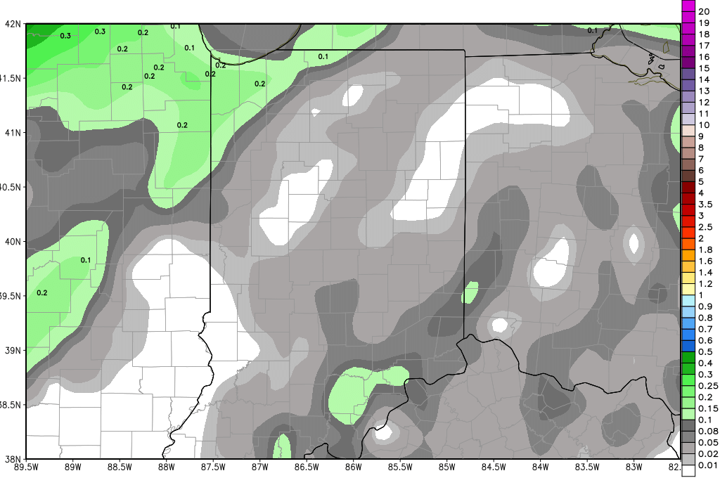
A cold front remains on track to cross Indiana tomorrow afternoon and evening. Moisture still looks to hit mostly norther areas. From I-70 northward, we can see a few hundredths to .2”, but we are increasing out coverage to near 70%. The best rain potential comes after sunset up to midnight, and will be closer to the Michigan line. South of I-70, we see nothing.

gfs_pr6_slp_t850_indy_32.png
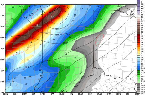
Dry weather sets up for the weekend and the first half of next week. Cooler air comes in behind the front tomorrow, so there will be a chilly start to Saturday, perhaps even pushing to near or below freezing for a bit. But we should see temps quickly rebound. Our next strong front has held together, while being delayed, and looks to bring rain mostly on Thursday. Some scattered showers may try and get into NW and far western Indiana on Wednesday afternoon, but the timing of the true frontal passage is not until the overnight through Thursday. Rain totals remain at .25”-1” with coverage at 80% of the state. We think the chance of getting rain to hold off all the way to Friday is limited at this time. The map above is a snapshot of action on Thursday morning. Still, that allows for a nice dry window for 4 and a half to nearly 5 days, depending on where you are at in the north…and nearly 7 days in southern Indiana.

The extended forecast period, features minor chances of precipitation. We still have a weak front bringing up to .25” around the 7th, and another system can pop up around the 9th, before a stronger front closer to the 12th.

Temps will warm to normal and slightly above normal levels next week in early May as the dry weather unfolds.


Indiana Weather Outlook 4-25-18

Dry weather is back over the state today. Clouds give way to more sunshine as the day progresses, and we should see moderate temps. The dry weather holds for tomorrow as well.

Our front for Friday continues to look very unimpressive. We won’t completely rule out moisture over the northern half of the state from Friday afternoon through midnight. Moisture totals will be anywhere from a few hundredths to .15” with 50% coverage. South of I-70, we feel confident now saying we stay dry. That will work out well, as those are the areas that saw the biggest rains over the past two days. The upper end of the aforementioned rain range will be near the Michigan line.

Dry weather then settles in for this weekend and now looks like it could continue through most of next week. Our strong front that we expect to sweep across the Corn Belt comes into western areas like IA and MO on time on Tuesday, but it runs into a significant blockage and is slowed dramatically. WE may not see rain develop here until late in the week next week – maybe Friday. That will allow for a nice, usable planting window, if things continue to work toward that solution. The map above is a look at total rain potential from now through next Thursday.

gfs_precip_120hr_indy_35.png

We keep a chance of rain in for late next week, the 4th into the 5th, and will keep rain totals from the front at .25”-1”. In the extended period, a weak front brings up to .25” around the 7th, and another system can pop up near the 12th. But, the pattern is showing some good chances for activity between strong fronts going forward.

Temps will warm to normal and slightly above normal levels next week in early May as the dry weather unfolds.

Indiana Weather Outlook 4-24-18

No significant changes this morning to our nearby forecasts. Yesterday saw significant shower activity over southern Indiana, and only minor light action up north. We have scattered showers and light rain popping up across Indiana through the day today, but coverage is not all that impressive. Rains statewide can look more like what northern Indiana saw yesterday and last night. We can see additional rain totals of a few hundredths to .25” with coverage at 60%.

We turn drier tomorrow as rain pushes off to the east. A few clouds may linger early, but sunshine is back for most of the afternoon. We then are dry for all of Thursday and the start of Friday as well. Our next front is still on track for late Friday midday and afternoon, but it is showing less moisture as it moves through. Right now we are pulling rain totals back to a few hundredths to .25”, still over 90% of the state. This will be a welcome change, as it really will allow for shorter delays in fieldwork.  Temps do move cooler behind the front.

A nice dry window holds from Saturday afternoon through the balance of the weekend, Monday and Tuesday. Temps will slowly build from slightly below normal levels to near normal by the end of Tuesday.

A strong cold front passes next Wednesday. This front brings rains of .5”-1” over 90% of Indiana. There can be some good thunderstorm action with this front. Rains finally end early Thursday morning. Models are starting to suggest this morning that this front could also be less impressive, much like our Friday front. However, we think that most of the lack of moisture is coming from a perceived lack of thunderstorm action, an idea we are not keen on leaving just yet. IF we see strong winds push up the leading edge of the front, there should be ample chances for instability to develop. So, we are leaving rain totals alone for now, but will continue to monitor.

As mentioned yesterday, the extended 11-16 period has a nice dry window from next Thursday afternoon right on through the 8th. Cooler Canadian air will be moving in for the period, but we still should be warm enough to spur decent evaporation and a return to fieldwork, so long as moisture stays at bay.

Indiana Weather Outlook 4-23-18

Moisture moves into Indiana a little faster in our forecast this morning, but that does not mean we are losing opportunity…we are just shifting our dry days around a little bit. Last week, going home on Friday, we were looking for moisture to hit for Tuesday and Wednesday. We are about 24 hours ahead of schedule this morning. By mid morning we will see rains spreading across southern Indiana, and by late this afternoon, we see rain threats over most of the state. Draw a line this morning from Terra Haute to Portland. South and east of that line we expect rains today to be from .25” to .75” with coverage at 80%. North and west of that line, we see a few hundredths to a tenth…that is about it, over 40% of the region. Scattered action holds over the state through tomorrow, bringing chance for an additional few hundredths to .15” of rain, but only 60% coverage. We should see everything done by late tomorrow afternoon. Combined rain totals will be near an inch in parts of far southern Indiana. The map below shows potential rain totals now through midnight tomorrow night.

gfs_tprecip_indy_11.png

So, with the rain arriving sooner, it leaves sooner, and we get a dry Wednesday and a dry Thursday. Temps today will be near normal, same tomorrow, and we should be slightly below normal for the dry days, Wednesday and Thursday. But, temps will still be pleasant, and we should see some drying.

A long, sweeping front moves though the state for Friday. Moisture does not look overly impressive, but we do see nearly 90% coverage as the front passes over all parts of the state. Rain totals will be .1”-.4”. But, action is done by sunset Friday night.

A nice dry window emerges for the weekend through next Tuesday. Temps will be near to slightly below normal as high pressure sets up over the top of us. This should provide a good window for field work, at least for a couple of days, maybe more for areas that get the lower end of the rain range from Friday’s front.

A strong, powerful front brings rain and thunderstorms for next Tuesday night through Wednesday. Rain totals look to be .5”-1” with coverage at 100% of the state. Strong to severe weather is possible from the front.

The entire 11-16 day period is free of significant rainfall at this time. We should see a dry window from next Thursday afternoon through at least the 8th. Temps will be slightly below normal as a Canadian high dominates that dry period, but still, we should see enough drying to allow for fieldwork in that window. Sunshine will dominate.

So, the forecast looks better than the past few weeks, with enough space in-between systems to allow for planting. Today’s action in southern Indiana will trigger some delays, but Friday will be the day we keep our fingers crossed for as little rain as possible from that front. If we escape with only a tenth or two…we should see significant planting progress as we head toward May tenth. Temps still lag normal for the most part, but are staying closer to it as we flip the calendar into May.