Author: weatherstud

Central Plains Ice Storm Update 1-13-17

Significant moisture will move over the Central plains from tonight through early next week. Right now, there is a substantial batch of cold air still sitting over all of Kansas, Nebraska, eastern Colorado and parts of northern/NW Oklahoma. Rains will be rotating up the backside of a strong surface high over the  Deep South. This moisture will “overrun” the cold air at the surface and move through a nice pocket of warm air aloft. This means our atmospheric profile is inverted (usually warmest at surface and cooling as you go up). This is a classic recipe for freezing rain and ice…as we are about to experience.

Major weather outlets have blanketed very large areas with ice warning and have really ramped up the fear mongering. Lets be clear. The worst ice, (much like the worst snows in a strong, classic winter storm) will be over a much smaller area that what has been put out there. That being said, the atmospheric profile is well set to see at least some ice in a lot of places. Most of the southern half of KS will see potential for ice, and northeast Kansas will see some too. We can see a period of about 6-24 hours with temps at or below freezing at the surface while well above freezing at 5000 feet. The longest periods will be found in central Kansas. These temps are going to dance around freezing very closely…usually from 30 to 32, and there will be some pushes to 33 in there. Still, once ice forms, it is fairly easy to add to it, even if you do go above 32 by a few tenths or even a degree from time to time. All of this points us to the conclusion of a pretty good ice event. Note: we are well under other ice totals out there…as you will not see any shock an awe numbers of 1.5″ of ice. But…to be clear – you can skate on .1″ of ice just as easily as you can on 1″…so its going to be treacherous. The one thing that thicker accumulations impacts is infrastructure – like power lines, trees, ect. That will be what bears the biggest threat from larger ice accumulations. Particularly, we are looking for some very gutsy winds later Sunday and Monday as the ice is done, but the heavy rain and storms are not. Big ice accumulations will not be nice to deal with there.

Below is a table we have put together to show the geographic coverage of the ice out of this event.

Area Moisture totals with surface temps at or below freezing  Time frame
Wichita .42″ Midnight Friday – Midnight Saturday
Emporia .22″ Midnight Friday – Midnight Saturday
Pratt/Medicine Lodge .34″ 6A Saturday – Midnight Saturday
Hutchinson .72″ Noon Saturday – 6A Sunday
Salina .92″ 6P Saturday – Noon Sunday
Topeka .30″ 6P Saturday – Noon Sunday
Concordia .32″ 6P Saturday – Noon Sunday
Dodge City 1.14″ 6A Saturday – 6A Sunday
Garden City 1.06″ Noon Saturday – 6A Sunday

A few notes: In the Hutch area, we see most all of that moisture coming with temps right at 32 at the surface, and closer to 42 at 5000 feet. So…warm rains may lead to less freezing, and temps may fluctuate more and see more time at 32.5 to 33 degrees. keep your fingers crossed. By the same token, while the dodge city total is impressive, we are saying right up front that we are not at or below freezing the entire time, so that liquid potential is not even close to being all ice, the way we see it right now. However, heavy moisture is still going to be an issue. To me, the place of biggest concern is north central KS, particularly around Salina – where temps are colder, and moisture could be heavier.

gfs_tprecip_kansas_15

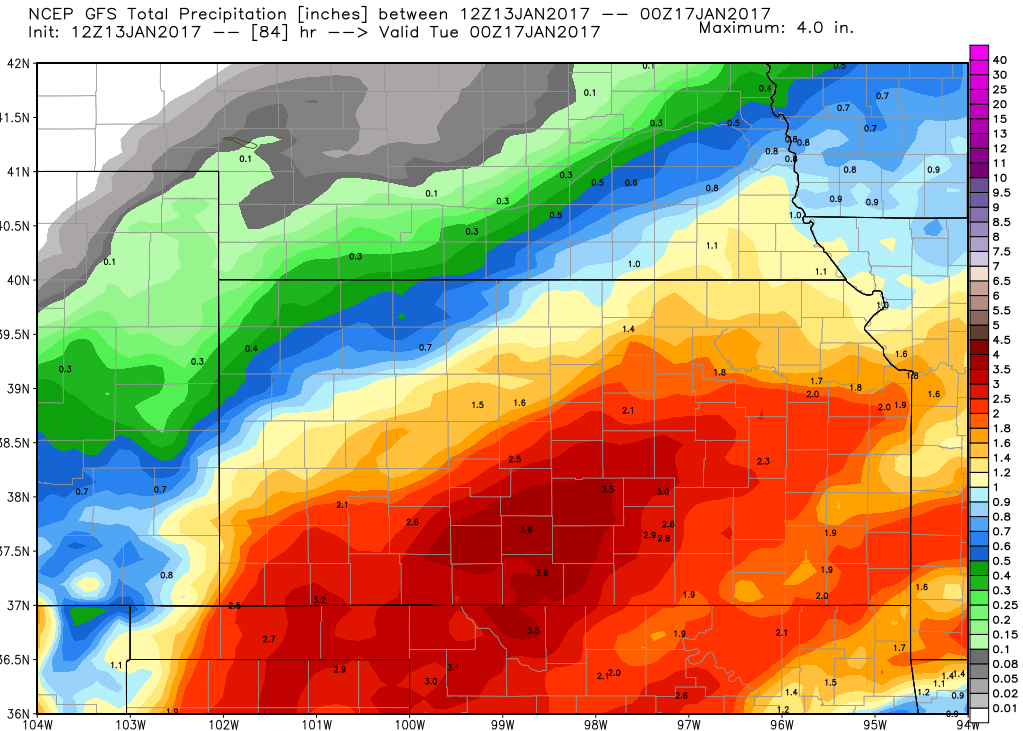
All of this freezing potential is done and out of the area by midday Sunday at the latest. However, moisture is not done. We can see another 1-2.5 inches of rain through the central plains before we get out of Monday. So…look for some localized flooding. The map at above shows rain totals through Tuesday. This is not ice…its total rain. While this model map may be a little bit over done at its zenith…1-3 inch rain totals are easily possible…and we probably should not say we would be surprised if there were some 3+” totals here or there. These moderate to heavy, warm rains will cause rapid melt. Wind will likely trigger some fairly impressive projectiles. Please be careful.

If you want to find the silver lining, or want to stay as positive as possible — 2 inches of moisture will go a long way toward shrinking the driest areas on the most recent drought monitor!

So, to wrap up…while we don’t think other news outlets should have screamed sensationalistic headlines all week…this will be a situation to be smart about, stay home, and expect things like power outages, snapped trees/limbs, and flooding.


International Weather Snapshot 1-13-17

South America weather:

  • Scattered hit and miss showers will be the rule through today and into the weekend in Brazil, giving .5-1.5” of rains over 75% of growing areas.
  • Hit and miss shower action continues Monday-Wednesday of next week.
  • Wednesday afternoon-Friday, the showers get better organized, with moisture moving across Parana and Sao Paulo, over northern Matto Grosso do Sul, into Matto Grosso and Goias.
  • Combined rain totals look like 1-2” before a big batch of heavier rains fall in western Matto Grosso on Thursday-Friday, adding an addition 1” of rain.
  • Some of the heaviest precipitation develops outside of the main growing areas west of Matto Grosso on Friday-Saturday of next week.
  • The rest of Brazil stays a little drier next weekend but it’s nothing to be concerned about at this point.
  • Moisture moves back in during the 11-16-day forecast with a combined .5-2” of moisture potential.
  • Temps in Brazil are trending higher, normal to slightly above over the next 7-10 days, with the good moisture and slightly above normal temps through the end of the month.
  • Drier weather is emerging in Argentina over the next few days as high pressure over Buenos Aires transfers east.
  • A minor front kicks up over BA tonight and heads north, turning into a bigger deal in the northern third of the country Saturday night-Sunday with .5-1” totals, but nothing more than scattered showers in BA, southern Cordoba, and into La Pampa.
  • Later next weekend-early next week, the northern feature turns into a bigger mess, with coverage expanding to the northern half of the country Sunday night-Monday, with totals over that period from .5-2” in the northern half of the region.
  • That likely means we’ll see net drying in central and southern Argentina through the first part of next week.
  • Strong high pressure parks over the country and keeps things dry Tuesday-Thursday.
  • Showers kick up in SW BA on Thursday afternoon, but they go away quickly and things stay dry through Friday.
  • Despite rains in the northern half of the country, the overall 10-day pattern is drier, and that’ll take the temps to normal to above, but normal to slightly below over this weekend.


Ukraine/Black Sea region:

  • Warmer air is moving in over the next few days and cold temps over the region should ease quickly through this weekend.
  • They’ll see well above normal temps, right at freezing and above, and any systems that come in will be all rain.
  • Temps fall back into the single digits by Saturday afternoon, so snow is possible in Ukraine and central/southern Russia into early next week.
  • Temps in the single digits and below zero from Sunday-Tuesday, so if the snow does melt, it’ll be talked about a lot in the markets.
  • I don’t think it will lead to wide ranging winterkill, but the roller coaster temps are something to keep an eye on.
  • No over the top moisture over the next ten days

Regional Weather Outlook 1-13-17

Corn Belt weather:

  • High pressure is moving over MN and IA this morning and a residual high is parked off the southeast US coastline.
  • In between is a plume of moisture running from northern AR across northern KY, but stays south of the OH River; as the high in the Upper Midwest moves east, that moisture will pivot, running from MO across southern IL and into southern IN, and then it’ll move north by tonight.
  • Scattered rain showers will fall in southern IL, southern IN, and MO, and it should stay rain as the freezing line is closer to central IN and IL.
  • The moisture will begin to push up into the cold air dome by tomorrow morning, which may mean minor icing concers of .1” in central IN and central IL; it looks to fire off in the I-70 area but likely doesn’t get much farther north.
  • There’s a small break on Sunday as moisture concentrates around a low in the plains, so there will still be some scattered light rain/icing in central/southern IL on Sunday and then moving back through MO, but it should switch over to rain fairly quickly.
  • That brings heavy rains to the Corn Belt Monday-Tuesday, from .25-1” across the Belt and hit 90% of the Corn Belt this weekend, with snow falling in the Upper Midwest.
  • There is some concern aobut localized flooding in areas of the Corn Belt as a lot of streams in the eastern Belt are running at capacity and there is heavy field ponding, so another 1” isn’t going to help.
  • Dry weather will be the rule Wednesday-Friday, but strong south winds by next weekend mean our next system is set to move in, starting in the MO valley by Saturday morning, and then it starts east, hitting 75-80% of the Corn Belt next weekend, Jan 21-22 with .5-1.5” totals.
  • It should be mostly rain except for snow again in the Upper Midwest, but the warm air surge next week could switch it to rainfall very easily.


Deep South weather:

  • Rain is in line next week for the Deep South, but this weekend, high pressure will dominate; there will be some rain moving from AR through KY, but that’s it.
  • Rain kicks off by midday Monday, a line of thunderstorms kicks off in LA with showers and thunderstorms up into AR, marching east all the way through early Thursday, hitting 95% of the region with .5-2” of rain.
  • The heavier end of the range is in the west where thunderstorms are more widespread, with less chance of thunderstorm development in the east.
  • A dry and windy Friday will follow that up, possibly spurring showers on Friday night-Saturday, and then a strong front will move through the south from Saturday midday-Monday with 1-2.5” of moisture, with the heaviest action in LA, MS, AL, and GA.
  • Heavy rains will also fall in NC and SC on Monday of next week too.
  • Very stormy and soggy in the Deep South over most of the upcoming 10 days.


Great Plains weather:

  • The story is an ice storm that’ll move through this weekend, especially in KS and OK, with the effects of the storm felt up into NE and SD.
  • The hardest hit areas of KS will include Salina, from 6 p.m. Saturday through noon Sunday, about .9” of moisture will fall in that window where temps are at or below freezing at the surface while it’s very warm aloft; it doesn’t necessarily mean a full one inch of ice, but it does mean there is potential for some nastiness.
  • Hutchinson could be in the .7” of moisture range while temps are at 32 degrees or lower; farther south near Medicine Lodge/Pratt area, .3” of an inch, Witchita .4”, and Emporia looks at .25” of moisture.
  • Topeka and Concordia likely see 1/3” of moisture; another potentially challenging area is in southwest KS because over an inch of moisture will fall, with temps yo-yo’ing back and forth above and below the freezing mark.
  • The ice will be a problem through Sunday before rains continue on Monday-early Tuesday that could add another 1-1.5” liquid equivalent of moisture on top of that.
  • Ice comes first and then rain falls on top of it to help melt the ice as there is a potential for some major issues.
  • I’m not ready to call for gloom and doom, but ice storms in this part of the country tend to be epic, and this one looks to have plenty of moisture to work with, so it all comes down to temps and who stays above and below freezing.
  • Farther north, nothing is going on over the weekend, with moisture trying to move into NE on Monday and possibly extreme southeast SD.
  • The middle of next week looks dry in the plains before a residual system sets up over the northern plains, bringing light rain and snow before the low gets cut off and parks over ND from next Sunday-Monday; it could bring some heavy snow and strong winds that’ll mean blizzard conditions.
  • Temps in the plains will be normal to above, including well above normal heading into early next week.
  • Highs in ND are typically 14 degrees, but they could be pushing 40 next week, but keep in mind that’ll likely change at the turn of the month.

International Weather Snapshot 1-12-17

South America weather:

  • Showers and thunderstorms are popping up in Matto Grosso today, with scattered hit and miss showers through the rest of the week and into the weekend elsewhere, giving .5-1.5” of rains over 75% of growing areas.
  • Hit and miss shower action continues early next week, Monday-Wednesday.
  • The showers get better organized from Wednesday afternoon-Friday, with moisture moving across Parana and Sao Paulo, over northern Matto Grosso do Sul, into Matto Grosso and Goias.
  • Combined rain totals look like 1-2” and then a big batch of heavier rains fall in western Matto Grosso on Thursday-Friday, adding an addition 1” of rain.
  • Some of the heaviest precipitation develops outside of the main growing areas west of Matto Grosso on Friday-Saturday of next week.
  • The rest of Brazil stays a little drier next weekend but it’s nothing to be concerned about at this point.
  • Moisture moves back in during the 11-16-day forecast with .5-2” combined in that forecast.
  • Temps in Brazil are trending higher, normal to slightly above over the next 7-10 days, with the good moisture and slightly above normal temps through the end of the month.
  • Drier weather is emerging in Argentina over the next few days as high pressure over Buenos Aires transfers east.
  • A minor front kicks up over BA on Friday night and heads north, turning into a bigger deal in the northern third of the country Saturday night-Sunday with .5-1” totals, but nothing more than scattered showers in BA, southern Cordoba, and into La Pampa.
  • Later next weekend-early next week, the northern feature turns into a bigger mess, with coverage expanding to the northern half of the country Sunday night-Monday, with totals over that period from .5-2” in the northern half of the region.
  • That likely means we’ll see net drying in central and southern Argentina through the first part of next week.
  • Strong high pressure parks over the country and keeps things dry Tuesday-Thursday.
  • Showers kick up in SW BA on Thursday afternoon, but they go away quickly and things stay dry through Friday.
  • Despite rains in the northern half of the country, the overall 10-day pattern is drier, and that’ll take the temps to normal to above, but normal to slightly below over this weekend.


Ukraine/Black Sea region:

  • Warmer air is moving in over the next few days and cold temps over the region should ease quickly by this weekend.
  • They’ll see well above normal temps, right at freezing and above, and any systems that come in will be all rain.
  • Temps fall back into the single digits by Saturday afternoon, so snow is possible in Ukraine and central/southern Russia into early next week.
  • Temps in the single digits and below zero from Sunday-Tuesday, so if the snow does melt, it’ll be talked about a lot in the markets.
  • I don’t think it will lead to wide ranging winterkill, but the roller coaster temps are something to keep an eye on.
  • No over the top moisture over the next ten days