Month: January 2017

Regional Specific Weather 1-5-17

Corn Belt weather:

  • Light snow is working across the eastern Corn Belt this morning across IL, IN, OH, and down into KY.
  • The best accumulations are along the OH River valley and that’s causing problems, especially the farther south you go because they aren’t used to driving in the snow.
  • The snow is gone by later tonight and high pressure will be in control for the balance of the week and weekend.
  • While the high has modified a bit, it’s still an artic high, so they’ll see below normal temps in the eastern Corn Belt by Friday.
  • The Corn Belt will be on the backside of the high pressure early next week and that will bring in south winds and will moderate temps dramatically, first over the western belt late Sunday night and through the eastern belt by Monday.
  • The next system will hit the Corn Belt Tuesday, with the low moving through IA in the afternoon and lifting northeast, and significant snows develop on the topside and backside of the low in MN, eastern ND and SD, and WI, so it will basically be an Upper Midwest snow event.
  • Snow totals could be 3-6” or better; south and east of there will see nothing but rainfall and very strong southwest winds.
  • Rain totals will be .25-.75” from MO up through IL, IN, MI, and OH; the bulk of the rains should be done before another round of cold air moves in.
  • If the low slows at all, that could allow the cold air to catch up and would make it a more dramatic event in areas east of the MS River.
  • Strong high pressure is then in play Wednesday-Friday, with the possiblity of an Alberta Clipper moving through the northern Corn Belt areas on Thursday afternoon, bringing some snow to MN, WI, northern IA, and northern IL.
  • Another round of bitter cold air moves in behind it with zero degree temps down to the I-80 corridor.
  • Another strong low kicks out of the western plains and moves into the western Belt on Saturday, January 14th, bringing snow to MN, IA, IL, and IN; there will be overrunning snow that could make this a potentially significant weather event.


Deep south weather:

  • Snow will develop this weekend, starting in the OH River valley right now and moving east before starting again over a residual boundary in the Deep South on Friday afternoon.
  • They’ll see some initial light rains in LA, MS, and AL, but as it lifts north and east, it gets caught in cold air, turning into a potentially significant snow event in NC and SC, as well as VA on Saturday.
  • Liquid equivalents will be .25-.75” and if the event does stay all snow, it could mean 6-8” of snow in southeast VA and NC, with lesser amounts in northern GA and eastern TN, with around 1-3” possible in those areas.
  • Everything is done by Saturday night before a dry pattern emerges on Sunday-Monday, with gusty winds cranking up in the western part of the region Tuesday.
  • A frontal boundary brings significant rains into the region on Wednesday morning, including AR, western TN, MS, and LA, before working eastward on Wednesday afternoon-Thursday.
  • Rain totals will be .25-1” with coverage at 90% of the region on Wednesday-Thursday.
  • Dry weather will emerge by Thursday afternoon, hold through Friday, and then a few scattered showers pop up in the South by Saturday; the focal point for development is to the north, but with the way it’s developing you may need to watch for a cold front developing next weekend.
  • That front likely moves through on Sunday and gives another .25-.5” of rain to 75% of the Deep South.
  • Outside of the cold air that creates snow this weekend, the rest of the 10-day forecast is pretty good for the other areas, including FL; while it in normal to below normal temps, they won’t be dangerously below normal.


Great Plains weather:

  • Light snow is working through the central and southern plains today-tomorrow, with light snow now coming through NE, across KS, and eastern CO today, leaving a coating to 3” in spots.
  • Through the overnight hours into tomorrow, the system consolidates in NM, they could see heavier snows in the TX and OK panhandles as well as eastern CO.
  • Totals could be 3-8” in southeast CO down through NM and that may be a conservative estimate at this point.
  • High pressure is dominating the northern plains, but will overspread the entire plains by tomorrow, so dry weather and bitter cold temps will be in play this weekend in the plains.
  • South winds will kick up by Sunday and begin to moderate the temps a bit and bring a nicer start to next week.
  • A fairly signficant low moves into the northern plains on Tuesday, bringing snow to ND, SD, and northwest MN, with snow totals of 2-5” or more in spots, but none of this action will spread into the central and southern plains.
  • A secondary system will try to get going later next week as a clipper system brings snow to ND, SD, and parts of MN; won’t leave a lot of snow but more cold air comes in behind it.
  • Friday night-Saturday, a low moves into KS but it looks like the moisture source is far enough east that it won’t mean more than scattered snow showers in NE, SD, ND, and eastern KS.
  • Temps will be normal to slightly below, fueled by a big cold air push this weekend, but next weekend will be more normal to slightly below.

Indiana Weather Outlook 1-5-17

image002-1
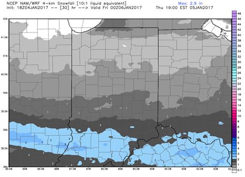
Light snows overspread the state today, as high pressure moves in with a little moisture trapped underneath. This will lead to fairly constant snow shower activity across the state, but and some minor accumulations when all is said and done. However, the best accumulations will be in the central and southern parts of the state where snow is a little less frequent, so there can be some travel issues through the day today. We will need to watch for some slick spots at times, although winds will not be overly strong in the central and south. We like accumulations today from a coating to 3”, with the coating most likely up to the north, and accumulations increasing to closer to the 3 inch range in southern Indiana. Best timing is from early this morning right on through the day. . North winds may enhance the snow potential over far northern parts of the state in typical lake effect areas. The map above shows snow totals through 7 pm today.

Dry weather is back in for tomorrow through next Monday. Cold temps hold over the state thanks to strong northwest flow through the weekend. However, as we translate onto the backside of high pressure on Monday, we should see southwest winds develop over the state, and that will begin to moderate temps somewhat.

Scattered light rain shower action develops early on Tuesday of next week, and then we see much stronger rain action move in late in the afternoon through the overnight and into early Wednesday. By Wednesday noon, all rains should be off to the east, meaning this system is picking up speed, and is developing into a nice frontal passage, rather than being a slow, sagging, stagnating front ending up in the OH Valley. This should promote rain totals of .25”-.75” with coverage at 90% of the state. Much colder air comes in behind, but it should be well after the moisture has left, so at this point, we still do not have major concerns over any rain changing to snow.

Dry for Thursday and Friday. Colder than normal temps will settle over the state, with temps struggling to work through the 20s in the north, and barely getting into the 30s in the south. Then, as we move into the following weekend, we see a strong low lifting out of the mid-Mississippi river valley, bringing plenty of moisture with it. WE are concerned that we can see a rain/snow mix over the state. However, models are far apart on this period, with the GFS staying very warm, and very wet, with the best moisture waiting until closer to the 17th. Our bias as this point will continue to be colder, with active systems passing through. That will lead us to look for some rain and snow potential for the 14th and 15th, and then another system likely farther out in the extended window, closer to the 19th. Moisture totals from these systems will be up to half an inch of liquid equivalent. However, it could be more, as we are taking a very conservative approach to these systems at this time.

Bundle up…cold air will dominate for the coming few days, and even the moderating push next week will only last a day or two. It is definitely winter across the Hoosier state.


International Weather 1-4-17

South America weather:

  • No significant changes in South America weather with Brazil seeing timely rains in most growing areas over the next 10 days.
  • The drier area in northeast Brazil is still getting attention as no serious rains look to fall in that area, which includes Bahia, northeast Minas Gerais, and part of eastern Goias.
  • That area is not big on row crop production right now, instead growing mostly cocoa and coffee, but Bahia does grow corn right now and will need some rains in the next 10 days.
  • Moisture is going to be limited to places like Matto Grosso, Matto Grosso do Sul, and through south/southeast Brazil, and that’s a good thing as those are the biggest crop production areas right now.
  • Temps in northeast Brazil will be a good 5-7 degrees above normal over the next five days and overnight temps will be warmer too with no rainfall in the short term.
  • Most of the action in Brazil this week will be pop up, heat based thunderstorms, and we don’t see any fronts moving across the country for the rest of this week.
  • This week, we’ll see below normal rainfall in Brazil’s key growing areas, likely .25-1.25” combined now-Sunday, with those drier areas still not getting rain this week as well.
  • Better moisture develops in south/southeast Brazil next week, from southeast Matto Gross over to Goias through southwest Minas Gerais and areas to the south of that line.
  • Rain totals next week will be 1-2” combined and it’ll park for multiple days in those areas.
  • That leaves the balance of Matto Grosso, northern Goias, Minas Gerais, and Bahia dry again.
  • Temps in those drier areas look to be normal to above, with the rest of Brazil trending normal to slightly above.
  • Northern Minas Gerais is likely the area that’ll develop heat stress with the warmest temps in the forecast.
  • Harvest is underway in Matto Grosso and it’ll be aided by dryness in the short term.
  • Temps cool off next week and go back below normal in MGDS, through Parana, Sao Paulo, and southwest Minas Gerais, which means any heat stress isn’t going to be a long-term challenge.
  • The Argentina setup looks more like a north versus south deal.
  • Northern Argentina should see good moisture over the next 10-14 days, but central and southern areas will see lower totals.
  • A big cluster of thunderstorms over the northern half of Argentina growing areas that’ll put down 1-3” of rain through the balance of today.
  • High pressure will dominate Saturday-Sunday, but a small cluster of thunderstorms will fire up in BA and Cordoba on Saturday night.
  • Big showers will fall in the northern half to 2/3 of Argentina on Tuesday-Wednesday, with another 1-2” of rain and nothing in the southern 1/3 of growing areas.
  • The best action in the south will be tomorrow night-Friday, where they could see .5-1” of rain in all southern areas that had been missed up to that point.
  • All growing areas in Argentina get at least 1.5” of rain, with central/northern areas getting 2-2.5” over the next 10 days.
  • Temps in Argentina will be normal to slightly above as things get a little warmer in the north, with central and southern areas still cooler than normal during the day but warmer than normal at night.


Ukraine/Black Sea region weather:

  • Reports are that 80% of the winter crops in that area look very good and there’s nothing in the outlook that’ll change our thought process on that.
  • Moisture will come through in a timely manner as fronts sweep through, with one coming across the Black Sea and over southern Ukraine from tomorrow-Friday of this week.
  • Another system will move through at the end of this weekend/early next week.
  • Timely moisture and good snow cover for wheat areas in the region.
  • Temps are moving to normal/slightly below normal after trending above in recent days.
  • Brutal cold weather may move into Ukraine and parts of Russia by the end of the weekend and early next week, but there’s plenty of snow cover on top of the winter wheat crop.


Region Specific Weather 1-4-17

Corn Belt weather:

  • As a strong storm complex lifts away over New England, wraparound winds will kick up in the Corn Belt.
  • Strong northwest winds will howl over the Corn Belt but they should diminish as we go through the day.
  • Significant lake effect snow will fall along the eastern shores of Lake Michigan, the southern shores of Lake Superior, and the southern shores of Lake Huron and Lake Erie.
  • The snows will be significant but not wide ranging as the system won’t pick up a lot of moisture from the lakes and deposit it a lot further inland.
  • As high pressure works in tomorrow, it does bring some light snow with it across MO, IL, IN, and southern IA.
  • The moisture totals won’t be impressive as it may total between a coating to 1-2” in spots, plus there won’t be any significant winds with it.
  • The pattern will then be dry from Friday-Monday as high pressure will dominate.
  • South winds develop on the back side of that high on Monday-Tuesday, which will allow the temps to moderate somewhat after a below normal finish to this week and through the weekend.
  • The next system still looks to move through by the middle of next week.
  • It will have very strong winds Tuesday afternoon-Wednesday as a very strong cold front gets ready to move through, but I question how much moisture will be available.
  • Rains will move across IL, IN, and MI on Tuesday night-Wednesday, but the big question is does cold air come in quickly enough to change it to snow, and models don’t agree on whether it will or won’t.
  • If it stays liquid, moisture totals will be .25” to 2/3” across areas east of the MS River valley, but it likely ends with wet snow as winds blow 15-30 mph.
  • The track of the low itself isn’t the story as that’s up in Canada, but the frontal boundary attached to it is what’s causing the precipitation.
  • The track is a little uncertain and we’ll have to see where the cold air sets up and how quickly it arrives.
  • Light rains and snows arrive in the eastern Corn Belt later next week, Thursday night-Friday.
  • There will also be full snows falling in MN and WI, with bitter cold air following it in and 0 degree temps down to the I-80 corridor.
  • Arctic air still looks to be in line for the Upper Midwest for the middle of January.


Deep South weather:

  • Today/tomorrow look dry in the Deep South before rains move in at the end of the week.
  • Showers and thunderstorms break out Friday in LA, MS, and AL before developing into a significant batch of moisture through the weekend, working its way through the central and eastern parts of the region.
  • Rain totals combined will be .5-1.5” with 60% coverage; areas that may be missed include AR, TX, LA, and northern MS.
  • Strong high pressure will keep things dry Sunday-Tuesday, bringing temps in the low 30s all the way down to GA and SC on Monday night-Tuesday morning, but the high does move away fairly quickly.
  • South winds will move up the backside of the high by midweek before scattered showers work into AR and western TN Wednesday morning but won’t go much further south.
  • Moisture will develop out of the old frontal boundary in northern MS, northern AL, and TN Wednesday night-Thursday, turning into a system affecting the northern half of the Deep South on Thursday.
  • Moisture totals will be .25-.5” there but it doesn’t really go away as it refires a day later in TN, northern MS, and eastern AR.
  • The Gulf Coast are, east TX, and FL peninsula areas don’t see much to finish out next week.
  • Temps will be normal to somewhat below, especially as northern areas deal with colder air next week.


Great Plains weather:

  • High pressure is in control of the plains but there will be a weak system moving through the plains over the next 24 hours.
  • The low is moving through eastern CO and will sag southward from now-Friday, with moisture extending through parts of NE, then sagging southward through KS, the southeast part of CO, and through the OK and TX panhandle areas.
  • Moisture will be mostly light in the plains but heavier in the higher elevations, where they have winter storm warnings in eastern WY and central CO.
  • Totals will mostly be a coating to 1” but there could be 3-4” in the NE panhandle today-tomorrow morning.
  • High pressure is in control of the northern plains with bitter cold temps there, staying below zero until Friday afternoon.
  • The weather looks calm through the weekend up and down the plains.
  • A system moves across the northern plains on Tuesday, bringing a chance of light snow in ND, where they could see 1-4” from I-90 northward.
  • South of I-94, they’re looking at mostly gusty winds and cloud cover.
  • High pressure moves back in Thursday and keeps things dry through the end of the week.
  • A disturbance in SD on Friday could drop some snowfall before heading east into the Corn Belt through the weekend.
  • Arctic high pressure is back in play by next Saturday, and you’ll hear talk of the polar vortex again, with temps 0 or below all the way down to I-80.
  • It’s an active pattern but won’t generate a lot of moisture in the plains over the next 10 days.