A week of wet weather is here, and our forecast is actually wetter this morning than it was last time we talked last week. Now, not only do we see rains for the first half of the week, we see rains for the last half as well. Rains the first half of the week will have a slightly more northern bias, and rains the last half of the week will have a more southern bias. But, the results are that everyone sees more rain. The map below shows potential rain totals from now through Sunday. Here is how it all breaks down.
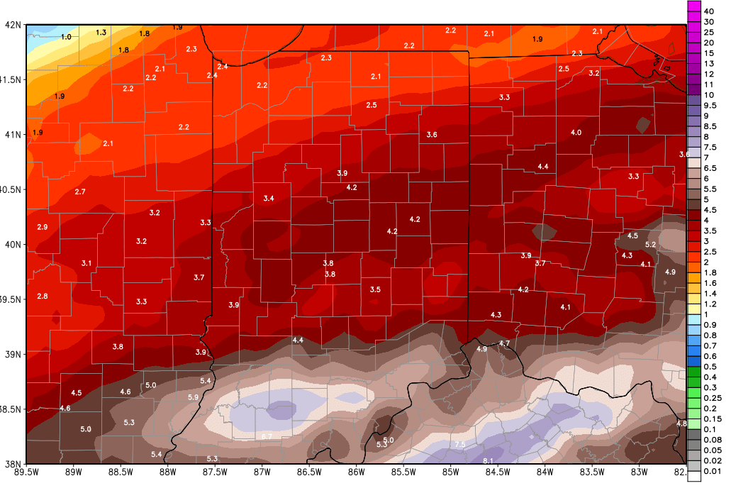
Rains today will work across the northern part of the state. .25”-1” rains are likely with 80% coverage from US 50 northward. Rains do not look like they will be able to carry all the way south today, meaning the southern quarter of the state misses out.
Rains tomorrow look a little lighter than today, but still should be worth .2” to .5” from I-70 northward, and we can see rains a little farther south over western parts of the state, perhaps pushing down closer to Vincennes. Once again, south central and southeast areas likely see little rains, but plenty of clouds.
Wednesday we have a strong front finally pushing in, and it will bring heavier rains. We see half to 2” rain totals over 90% of the state. The higher end of the range will be in northern and NW parts of the state, where thunderstorms are likely after midnight Tuesday through the overnight. Rains continue through the rest of the day as the front pushes south and east. Thunderstorms can re-fire Wednesday evening in southern Indiana, and run right on into Thursday morning.
Thursday will be mostly dry over the state but scattered showers hold on into early afternoon down near the Ohio River.
Friday we have another wave coming up from the southwest. This will bring rains of .5”-2” to areas south of I-70, and a few hundredths to a quarter of an inch north of I-70. Far northern parts of Indiana may miss out on that system.
Saturday, scattered showers are back with .25”-.5” from US 24 southward, and a few hundredths to a quarter of an inch up north. Coverage will be 80%.
Sunday has rains of .5”-2.5” over the southern half of the state again, and scattered showers up north with potential of a quarter of an inch or so.
We finally get a dry day in all areas of the state next Monday. In fact, we should be dry for at least 3 straight days Monday through Wednesday, as high pressure works across the eastern Corn Belt.
A strong system returns for the start of March on Thursday the 1st, pushing into the 2nd. This system brings rains again, with half to 1.5” potential on the conservative side. Late in the 11-16 day window we have a cold front that crosses the state but is part of a low that is centered farther north. That means we may miss the worst rains, but still can see up to half an inch around the 6th. The forecast pattern therefore can stay very wet with on through the first week of March.
Temps are mostly normal to above normal through the next 10 days, although we do cool down briefly this Thursday, and then again early next week behind strong cold fronts. But, the pattern does not show any significant cold air outbreaks through early March, meaning we expect mostly rain through the period.
