We have no change in our outlook this morning. A cold front is trucking across the state, and brought heavy rain into NW Indiana going back into last night. The front moves southeast through the day today, and rain should end in northern Indiana first, before tapering off in southern Indiana toward evening. Temps are markedly different behind the front, dropping a good 15-25 degrees from yesterday’s record levels. Strong winds will be seen as well. Rains from this front will come to half to 2 inches and rain coverage will be up to 100% of the state. Flooding is already a problem in some areas, and will become a problem in many more over the coming days.
Another wave of moisture comes up the slowing front from the southwest for Thursday morning. This brings another chance at half to 1.5” rains into southern Indiana for Thursday. The clouds around this wave get all the way into northern Indiana, and moisture can lift north of I-70, but we think the northern quarter of the state probably is able to miss out on this moisture surge and stay dry for Thursday, while the south gets potentially hammered again.
From there, pretty much everything stays the same. Friday we have another wave coming up from the southwest. This will bring rains of .5”-2” to areas south of I-70, and a few hundredths to a quarter of an inch north of I-70. Far northern parts of Indiana may miss out on that system.
Saturday, scattered showers are back with .25”-.5” from US 24 southward, and a few hundredths to a quarter of an inch up north. Coverage will be 80%.
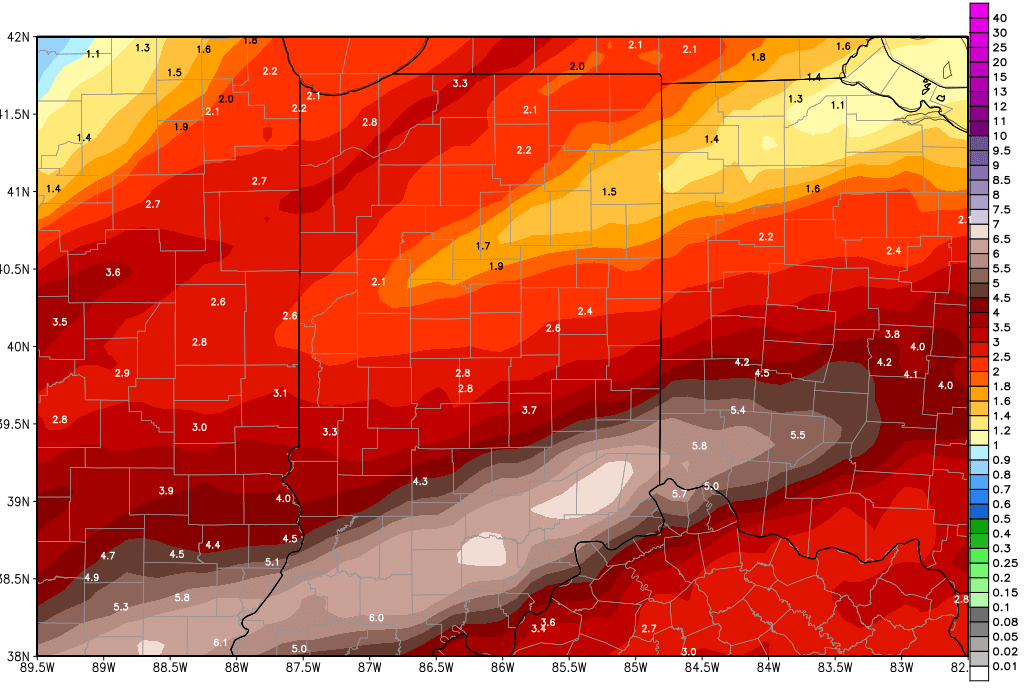
Rains still look to move our relatively fast for Sunday. We keep scattered showers around through the morning and they can bring .25”-.5” over about 60% of the state. But, we are removing potential for heavy Sunday rains, and we are also looking for a rain-free afternoon. We hesitate to call it a dry afternoon, though, after days of moderate to heavy rain. We are going to feel “damp” for a little while here. The map above shows updated rain totals from this morning through Sunday.
We finally get several dry days in all areas of the state for next Monday through Wednesday. High pressure moves over the eastern Corn Belt during that period.
A strong system returns for the start of March on Thursday the 1st, pushing into the 2nd. This system brings rains again, with half to 1.5” potential on the conservative side. Late in the 11-16 day window we have a cold front that crosses the state around the 6th with potential for half to 1.5” rains.
