A little good news this morning: we are rolling back rain totals just a bit over the rest of this week and weekend. We will not be rain free, but it looks like rains today and tomorrow will be less than we had seen (and feared). We still have potential for heavy rain overnight tomorrow night into early Sunday, but the geographical footprint is smaller. Here is how we see this working out.
Today, we have rain moving through the state. Rain totals will be mostly from .25”-.5” but we won’t rule out an occasional .75” amount here or there. The rain moves through fairly quickly, and will be done in most areas by early afternoon. Only far southern Indiana will see action linger into evening. This will allow a bit of a lull through the afternoon and tonight. Rain returns tomorrow and will bring potential for another .25”-.75” over the state with 80% coverage.
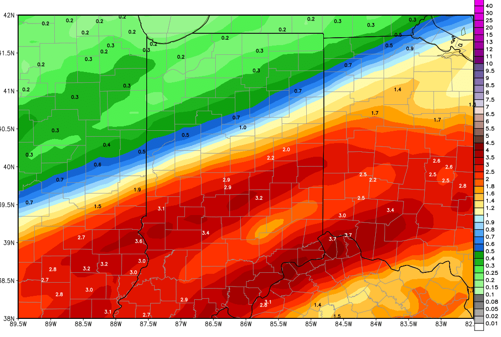
Overnight tomorrow night into Sunday morning we see a cold front bring significant rain and thunderstorm action to areas south and east of a line from Decatur to Terre Haute. This will be the last wave of moisture for this very active, rainy week. From this event, we can see 1-2.5” of rain south and east of the above mentioned line, but only a few hundredth to a quarter of an inch north and west of that line. Those rains will be very intense and we expect flooding problems to manifest in central and southern Indiana. But, the system is also moving quickly, and we should be completely done with rain statewide by midday Sunday. The map below shows moisture through Sunday evening, and keep in mind most of this happens overnight Saturday night through Sunday midday.
Drier weather finally arrives for Sunday afternoon and we see dry, sunny, rain free weather for Monday through Wednesday.
Thursday afternoon through Friday we have rains returning to the region. We look for .1”-.5 rains over 70% of the state. We follow that up with at least 3 more dry days, and may not see our next system until the 6th, where we can pick up half to 1.5” rains. The rest of the extended forecast is drier.
As far as temperatures go for the next 10 days, we look for temps to warm some this weekend with strong south flow ahead of that cold front for overnight Saturday into Sunday. Then temps will be normal to slightly below for next week. However, we still stay warm enough to be looking at mostly rain next Thursday into Friday.
