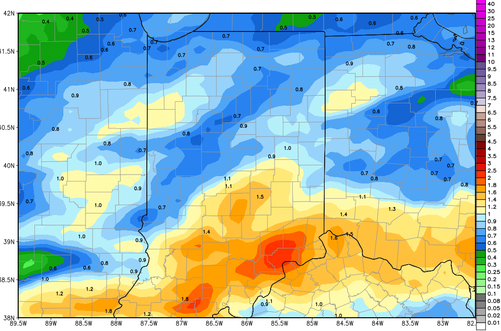
A soggy Tuesday is expected today as rains move through the state. The heaviest rains this morning will be in southern Indiana, and later this afternoon and evening we see that threat farther north. Thunderstorms can happen and there even is an outside chance we see some strong to severe weather, although it’s not a big chance. Rain totals remain on track to be from .5” to 1.5” over 90% of the state, and the remaining 10% will see rain…but may fall short of that half inch lower boundary. Temps today will be above normal, making the only day out of the next 10 to have that kind of temperature profile. The map above shows total precipitation potential through tomorrow morning.
Much colder air is on the way in for tomorrow. This cold air begins to blast in overnight tonight, but we think most of the moisture will be gone before it gets here. The northern part of the state still looks like it needs to expect some snowflakes here and there, mostly from US 24 northward, and in particular, in general lake effect locations. In some of those areas we won’t rule out a coating to an inch or two early Wednesday, but coverage of accumulation like that will be limited to about 30% of the northern third of the state. The rest of the north just sees flakes from time to time. South of US 24, we just see the cold air dominating at midweek. Parts of northern Indiana will struggle to get to the mid-30s Wednesday, and farther south, lower 40s will be a stretch.
Thursday should be dry statewide, and we see some sun in there. But, minor moisture moves in over the northern third of the state overnight Thursday night. This likely brings just clouds in most areas, but we will leave the door open to a few flurries and a bit of light snow from US 30 northward from sunset Thursday night to sunrise Friday morning. The rest of the state looks drier for Friday, as our southern wave has fallen apart.
Saturday and Sunday look to be mostly dry. High pressure moves across the state Saturday and we have some minor south winds in for Sunday. Still, cold air rules the weekend, and we see only minor moderation in temps for Sunday. South and southeast winds do develop Sunday afternoon ahead of our next system to start next week, allowing temps to get back closer to normal.
Next week still looks to start damp. Overnight Sunday night low pressure moves into the state, bringing .5” of liquid equivalent precipitation. However, colder air is looking to reassert itself, and we think that will lead to snow over a large part of the state. There is potential for a coating all the way up to 4” the way things look right now. This will be a wet snow, but without some kind of southern push, temps will be cold enough for snow. The cold lingers behind the initial system for Tuesday, when a second wave can come through (mostly in the morning) giving an additional .2”-.5” of liquid to central and southern Indiana, where some of that can come as a few more inches of snow. Clouds dominate over the rest of the state with the cold temps for next Tuesday.
Mostly dry but still chilly next Wednesday, and then finally heading into Thursday, we have south winds starting to moderate temps a bit. We could get back to near normal for daytime highs by late next week.
The extended forecast is largely unchanged this morning. Our next system still looks to develop out of a low moving over the eastern Corn Belt for the 13th. This system is farther south than 24 hours ago, and therefore is likely a less drawn out feature. WE still will look for .25”- 1” of rain across for that time period, but can expect drier weather for the 14th and 15th. A weaker front arrives on the 16th, with the potential of .1”-.5” of rain for Indiana. Finally, expect a strong spring storm complex for the 18th, and rain totals look higher. Right now we will project half to 1.5” rains out of that system.
So, while we have some tweaks, generally our thought process is unchanged this morning. Cold and damp will be the buzzwords through the rest of this week and through midweek next week. Then, we continue to see a fairly active precipitation pattern, even when temps start to moderate a bit. Nothing here makes us change our thoughts on potential field work in the next few weeks at all.
