Rains blew past expectations yesterday. We way undershot the level of moisture that ended up coming through. But…even if there was more rain than we thought or wanted, it does not change our focus for today…and that is on cold air!
Cold air started to blast in to the north and northwest part of the state overnight and will continue to sink south and east through the day. This is triggering some snow over the northern third of the state, particularly in lake effect areas. In those areas (Laporte, St. Joe, et al) we can see a coating to an inch or two on grassy surface. The rest of the northern third, from US 24 northward, we can see sloppy wet snow flakes and perhaps some minor coatings. The central and southern parts of the state should be mostly precipitation free, but cloudy and cold. Temps struggle to get out of the mid-30s in the north, 40s in the south.
Clouds mix with some sun Thursday and then another fast moving wave of moisture moves in over the northern third of the state overnight Thursday night. This likely brings just clouds in most areas, but we will leave the door open to light snow and flurries that can leave a coating to an inch from US 30 northward from sunset Thursday night to sunrise Friday morning. The rest of the state looks dry through the daytime hours Friday.
Overnight Friday night through Saturday moisture pushes up over the southern half of the state. This will trigger mostly snow from I-70 southward, and the best accumulations will be from US 50 southward. Liquid equivalent precipitation will be from .25”-.6” meaning we can easily see several inches of snow in the south. Everything is done by Saturday midday.
The Saturday and Sunday look to be mostly dry. High pressure moves across the state Saturday and we have some minor south winds in for Sunday. Still, cold air rules the weekend, and we see only minor moderation in temps for Sunday. South and southeast winds do develop Sunday afternoon ahead of our next system to start next week, allowing temps to get back closer to normal.
Moisture is back to start next week. Overnight Sunday night low pressure moves into the state. The system brings two waves of moisture, both triggering mostly wet snow. The first wave from midnight Sunday through Monday brings a coating to an inch or two to about 70% of the state. Then a second wave moves through Tuesday, with more intense precipitation .WE can see several inches of snow over 60% of the state, and there can be some rain mixing in, mostly over the southern third of the state. Still, temps are cold enough for mostly snow.
We finally put together about 36 hours of dry weather for the entire state from Tuesday evening through all of Wednesday. Next Thursday, precipitation is back, but with south winds, temps moderate just enough to be looking at all rain. Temps will not be above normal, but will not be quite so cold.
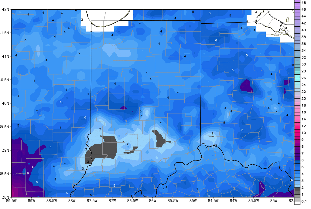
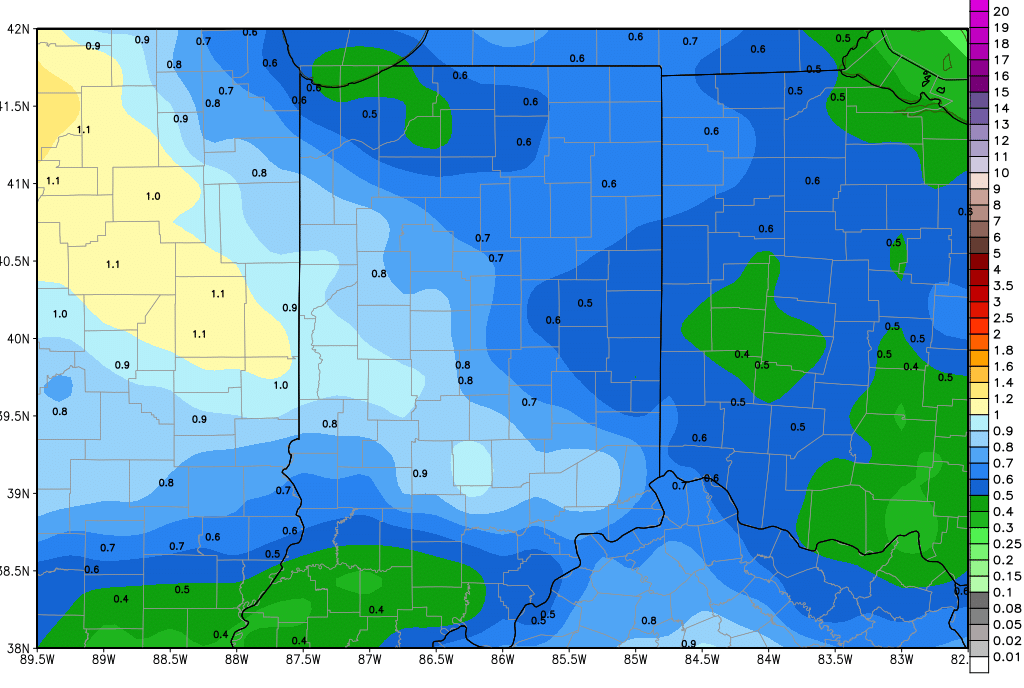
So, to put it in blunt terms, we see no day over the next 10 with temps above normal, and 9 of them will be below to well below normal. This colder surge has caused us to have to talk up snow much more this morning, and lessen our thoughts of rain. Soil temps will stay in the 30s through mid-month…and there can be no talk what-so-ever on field work through mid-month either. It’s not what we want to hear, but it is the truth. The precipitation forecast may get tweaked, but make no mistake…the pattern is cold and damp. The maps below show total 10 day snow accumulations (now through next Friday) at top, and total 10 day liquid equivalent precipitation at bottom.