Partly sunny and cold today. Winds may not be as strong as yesterday, but will still be out of the NW. This will bring down our next wave of moisture tonight. Scattered light snow showers overspread northern Indiana, working in over the norther third of the state. We can see a coating to an inch or so, likely very similar to what we saw at the start of the day Wednesday up north. South of 24, we should see just clouds and a few flurries
Most of the state turns out partly sunny on Friday. However, this respite will be short lived. Light snow is back into the state Friday evening, where we can see a trace to a light coating over northern and central Indiana. Then the front really ramps farther south. From midnight Friday night through midday Saturday, we can see at least 1-4” from I-70 southward. This will be quite a mess to be dealing with Saturday morning. Northern parts of the state start dry Saturday, and the entire state is dry for the balance of Saturday afternoon and evening. High pressure moves over Indiana Sunday, setting up in Ohio. This should give us some good sunshine to finish the weekend.
Our next system begins to toy with the region Sunday night, but still will draw out its effects into Tuesday. Sunday night we have light snow coming into the northern half of the state, from I-70 northward. This will bring a coating to 2 inches, but we think most of the region will be under an inch. There will be nothing south. The daylight hours will be mostly dry Monday, and then light snow comes back from US 24 northward for Monday night into Tuesday morning. The action there will be limited to an additional coating at best, but the snow spreads into east central Indiana for Tuesday afternoon. Notice that we are leaving southern Indiana out of the coverage for this event…this will be good, because we still will be dealing with the aftermath of Saturday’s snows in the south. This will actually equalize moisture across the state a little bit for the period.
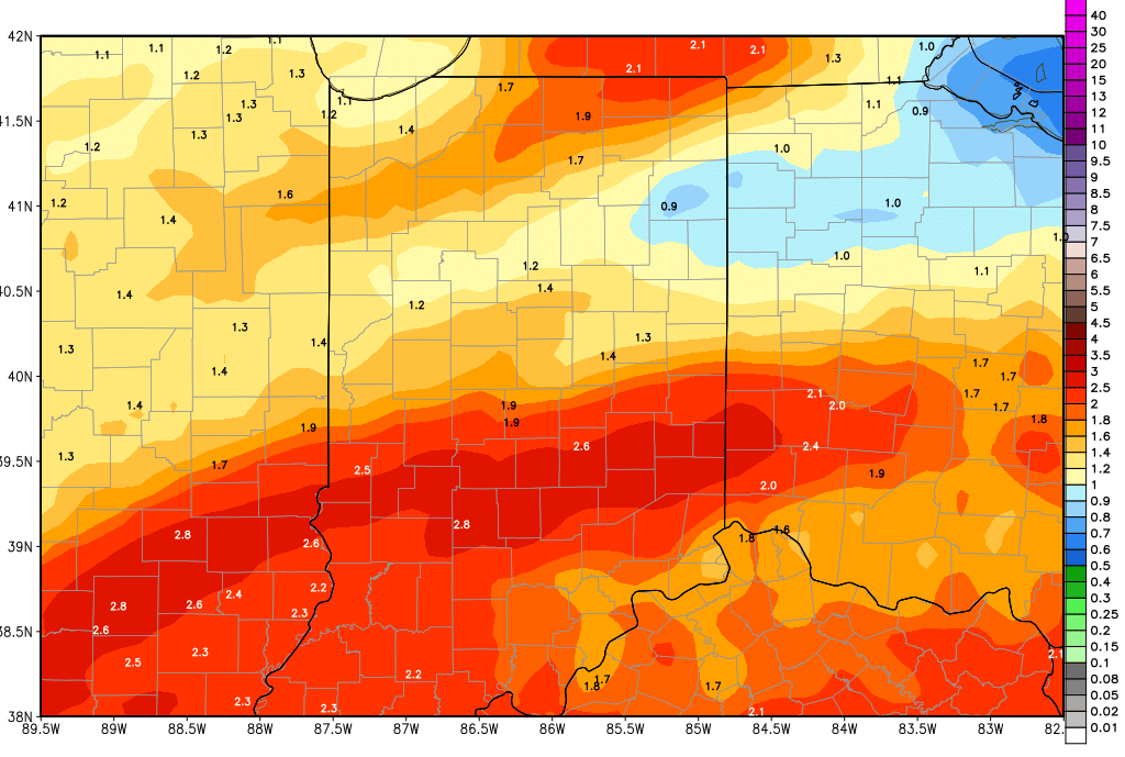
We are dry Wednesday. Thursday rains are here (yes, RAIN!!). But, they look to have the potential to be heavy. Right now we are looking at two waves coming through for Thursday and Friday, bringing combined rains of 1-2.5’ over 80% of the state. The heavier wave will be on Friday. Then we get a few dry hours Saturday morning.
In the extended window, we have .5”-1.5” rains for late next Saturday afternoon (14th) through Sunday (15th). These rains will have 100% coverage over the state. Spits and sprinkles linger for the 16th. Then, (and let’s not get too excited…this is far enough out it can easily change) we may be able to put together our longest dry stretch of the month! We see no precipitation for the 17th-18th-19th. Rain is back for the 20th, bringing .25”-.75”
Temperatures stay cold for the next week. We will be 10-20 degrees below normal now through next Wednesday. Then, we see temps climb quickly to above normal levels (in time to fuel the rain and thunderstorms) next Thursday and Friday. Behind that we are back to normal and below normal levels for the following weekend. The combination of cold air this week, ample moisture, and really only 2 above normal days out of the next 17 bring us to no change in our field work estimate: not getting in there for a while yet! Ten day moisture totals are below.