Dry and warm today and tomorrow. Southwest winds take temps up well above normal for the first time in weeks. We will see low relative humidity, high evaporation and excellent drying.
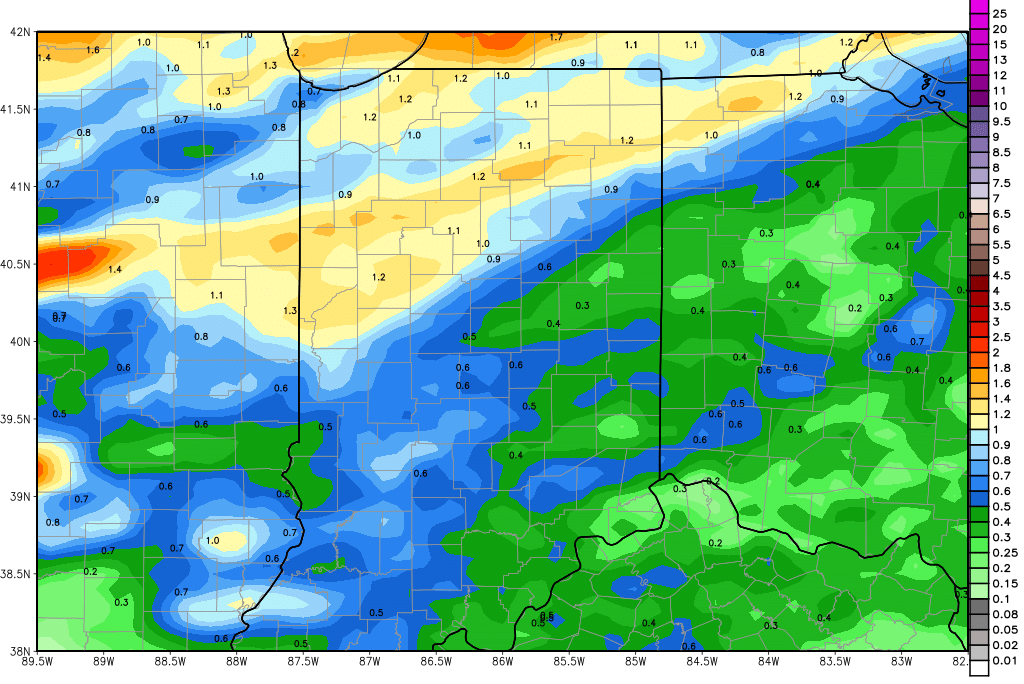
The timing and overall set up of our next rain event is unchanged. We have rain to start the day Thursday morning with an approaching cold front. Scattered showers hold through the rest of the day and through early afternoon Friday. The best chance for stronger rain and thunderstorms will be overnight Thursday night, but we see this event as less threatening now for the state. If we see any action, it again will be north, but we think the best chance for strong to severe weather will be farther west and north. So, because of lower thunderstorm chances, we are lowering our overall rain totals. Right now we look for half to 1.25”, and even that inch and a quarter total will take some thunderstorms to get to. Really, this will be a pretty good rain event, with most of the state falling in the half to 1 inch range. Coverage will be around 90%. The map above shows rain potential through Saturday morning.
We are dry for the balance of Friday through the Saturday. AT this point, we see clouds and a little moisture trying to develop for Sunday, but we hesitate to put much action in yet. We will take a look at additional data tomorrow morning and make a decision on whether we need to insert a quarter inch of liquid for the latter part of the weekend. Either way, we are dry again for Monday. On Tuesday, we still see the potential for a few minor spits and sprinkles near the Michigan line, but nothing anywhere else. There can be a few hundredths to a tenth or two around.
Dry for next Wednesday. A strong system arrives for Thursday the 10th and lingers through the 13th. That event can bring half to 1.5” rains to 90% of the region. As that circulation moves off to the east, we see the remainder of the 11-16 day period mostly dry, as high pressure parks right over the Great Lakes. Temperatures will be nearly normal to slightly below normal under that high.
