Author: weatherstud

Indiana Weather Outlook 5-9-18

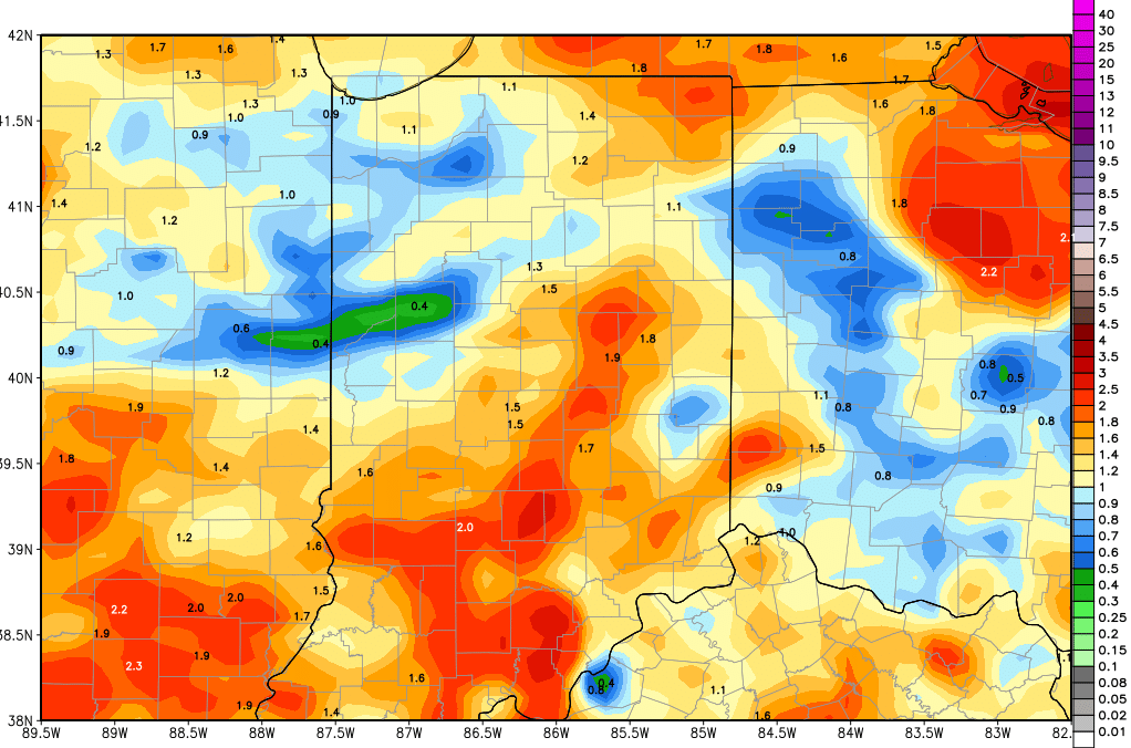
Clouds build through the day today as precipitation is on its way into the state. Action starts this afternoon in NW, north central and west central Indiana, and then spreads south and east form there. The best rains will fall this afternoon through midnight tonight. Rain totals will be from .25”-.75”. Strong thunderstorms do not look likely, which is why we are shaving a little off the top end of our previous rain range. The rains coming in a little faster mean that we see them leave a little faster too. Most action should be east into Ohio by shortly after sunrise tomorrow morning.

The rest of the day tomorrow is dry, with clouds giving way to sunshine. Temps will be a little cooler behind the frontal passage.

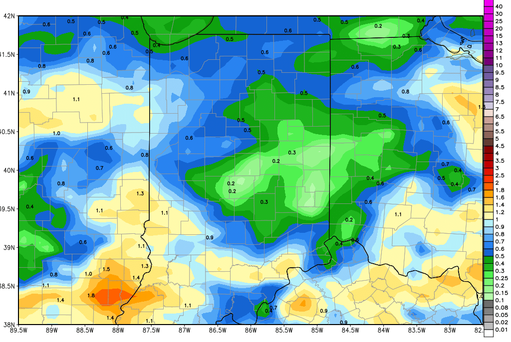
A secondary disturbance moves from the Upper Midwest across the Great Lakes for Friday and Saturday. This still looks to bring some rain into the northern half to third of the state Friday. Rain totals will be from a few hundredths to a quarter inch or so, with coverage at 80% of areas from US 24 northward. Between US 24 and I-70, we won’t rule out a shower or two, but don’t think it will be a big event. South of I-70 we see nothing. There is a similar tendency on Saturday too, with clouds and a few scattered showers from US 30 northward, but the rest of the state is dry. The Saturday rains can bring another few hundredths to .2”

On Sunday, a cold front sweeps through bringing precipitation back statewide. However, the coverage does not look as impressive this morning, and we think there could be some holes in the rain pattern. Right now we are paring back moisture to .25”-1”, and coverage back to 60% of the state. Thunderstorms do not look to be as strong and as moisture laden, and we do not see rains hitting the same areas over and over. So, this is going to be a friendlier rain event, at least the way it looks right now. An increase in energy or moisture can easily bring back thunderstorms, so we are not closing the book on this forecast yet…but we are looking at a more subdued system in our opinion. Rains linger into early Monday.

Dry for the balance of Monday and Tuesday. WE should see temperatures rebound. Wednesday is a little bit of a sticking point in our forecast this morning. WE have been keeping next Wednesday dry. However, a couple of models are trying to advance our next system forward about 12-24 hours from the 17th into the 16th. We want to see additional and confirming model runs before making a change. Either way, there is a system in there that can bring up to half an inch over about 70% of the state. Then we are dry for the balance of the 10 day window, right up to the 20th.

No change in our extended 11-16 day forecast window this morning. We continue to watch a cold front sweeping into the state for the afternoon of the 20th bringing rains of half to 1.5” over 90% of the state, and then a reinforcing wave of energy brings additional rains up to 2” for late the 21st through the 22nd. Given the recent system performance, we would suggest that these rain totals likely will be lowered as these systems get closer to arrival.


Indiana Weather Outlook 5-8-18

Sunny, dry and warm today. Sunny and warm tomorrow. Temps above normal

Clouds return tomorrow afternoon and precipitation breaks out tomorrow evening. Rain and thunderstorms move into NW, north central and west central Indiana near or after sunset, and action spreads south and east. There seems to be less of a threat of thunderstorms now, but until we see how the heat starts to interact with the front tomorrow, we will not be able to wave the all clear flag just yet. For now, we will leave rain totals tomorrow night through midday Thursday at .25”-1” with coverage at 80% of the state. Many areas will be at a half inch or less. By Thursday afternoon, rain is done in most of the state. We continue to see a secondary wave moving across the Upper Midwest into the great lakes for Friday and Saturday. That will leave the chance of scattered showers in over northern Indiana, from the Michigan line down to US 24, or at the very least plenty of clouds. Farther south, we have nothing going on for either day, Saturday or Sunday. If showers do pop up to the north, a few hundredths to a tenth or two will be all we are looking for.

Heavy rain and thunderstorms are in for Sunday, and linger though Monday midday. WE can see rains from half to 1.5” with strong to severe thunderstorm potential. 100% coverage of rain out of this event. The strong thunderstorms look to be most active in central and southern Indiana from midnight Sunday night through Monday morning. All action is done by Monday afternoon.

Dry weather is back for Tuesday and Wednesday. A weak frontal boundary lifts up from the southwest for Thursday the 17th, bringing .1”-.4” to about 60% of the state. The best coverage will be in southern and central Indiana. The map above shows total rains through the next 10 days. The bulk of this comes tomorrow night through Thursday and then Sunday night into Monday.

gfs_tprecip_indy_41.png

Going into the extended 11-16 day forecast window, we have a stronger cold front sweeping into the state closer to the 20th bringing rains of half to 1.5” over 90% of the state, and then a reinforcing wave of energy brings additional rains up to 2” for late the 21st through the 22nd.

Temperatures the second half of this week will pull back closer to normal, and then move slightly above normal levels heading into next week again, before that front develops on Thursday. We do expect a significant temperature correction behind the strong thunderstorms that are possible later this Sunday.

Indiana Weather Outlook 5-7-18

Dry through the next 3 days. We see sunshine, blue sky and temperatures slowly climbing as south winds return. WE should see good drying and good evaporation through the period.

Clouds return Wednesday afternoon and precipitation breaks out Wednesday night. Rain and thunderstorms will be at their zenith from just ahead of midnight Wednesday through Thursday sunrise. Rain totals look to be from .25”-1” with coverage at 80% of the state. By Thursday afternoon, rain is done in most of the state. Friday and Saturday will be dry from US 24 southward. However, the northern third of the state will see lingering cloud cover through at least Friday and perhaps Saturday. We think precipitation stays mostly up over MI, but the long and short of it is that we can’t completely get rid of a chance of showers those days up north, and drying will be limited. Friday in particular we can see a few hundredths to .25” of moisture over about 80% of the state north of SR 26. The map shows rain totals through Saturday morning.

gfs_tprecip_indy_25.png

Heavy rain and thunderstorms are in for Sunday, and linger though Monday midday. WE can see rains from half to 1.5” with strong to severe thunderstorm potential. 100% coverage of rain out of this event. The strong thunderstorms look to be most active in central and southern Indiana from midnight Sunday night through Monday morning. All action is done by Monday afternoon.

Dry weather is back for Tuesday and Wednesday. Our next front likely develops later in the extended 11-16 day forecast window. A cold front sweeps through around the 20th bringing rains of half to 1.5” over 90% of the state. A reinforcing wave of energy brings additional rains up to 2” for late the 21st through the 22nd.

Temperatures this week will be normal to above normal, with the warmest air coming in ahead of the front on Wednesday. This weekend though will feature good strong south flow funneling warm air in to the Sunday event. Basically we see no cold air outbreaks in the next 2 weeks.

Indiana Weather Outlook 5-4-18

Scattered showers hold over the state today as our frontal boundary finally looks to clear the eastern Corn Belt this afternoon and tonight. Rains are not all that impressive today but will be able to add an additional .25-.5″ of liquid to about 80% of the state. The heaviest precipitation is over this morning, as thunderstorms fired off last night. Clouds hold through most of the day, but we could start to see some clearing in northern and western Indiana shortly after midday. Farther east and south, clearing may not truly begin until closer to evening. Winds will shift to the west and northwest as the front comes through, but still may be a bit strong.

Dry weather dominates the region overnight tonight and tomorrow. We should be clear through Saturday and have sunshine to start the weekend. On Sunday, we see a minor disturbance coming back across the great lakes and eastern Corn Belt. This system does not have a significant amount of moisture with it, but will bring lots of clouds, and can trigger light rains. From late morning Sunday through Sunday night we see a few hundredths to .4″ of rain, and we are expanding coverage to about 70% of the state. This moisture is not impressive, but if we see clouds and even minor moisture on Sunday…what are we not seeing? That’s right…drying.

We are dry with sunshine for Monday-Tuesday-Wednesday. Temps will be working higher through the period, with temps well above normal again on Wednesday ahead of our next front. Through those three days we will see good drying, with low humidity levels and evaporation from .18″-.25″ of moisture per day.

A strong front sweeps across the entire state Thursday. Precipitation starts late Wednesday night, closer to midnight, and then goes through the entire day Thursday. Rain totals can be from .25″-1″ with coverage at 90%. The key to higher rain totals will be thunderstorm development. If the moisture speeds up a bit, and can feed off of warmth from Wednesday afternoon, thunderstorms become more likely.

Friday and Saturday should be mostly dry with clouds giving way to sun on Friday. Temps pull back closer to normal.

The rest of the 10 day period and the extended forecast window shows a relatively active pattern, with a system coming across the region every couple of days. We see scattered showers for Sunday the 13th. This wave so far does not have an exceptional amount of moisture with it, but we are watching to see if it wants to strengthen. At this point, we are expecting .25″-.5″. The rest of the extended period brings another system late the 16th into the 17th with .25-.75″ rains over 70% of the state. Then, closer to the 20th, we see a slower, sagging front coming in from the NW, and it can bring .25″-1″ over 60% of the state.

Temperatures are mostly normal to above normal through this next 2 week period. Excessive heat is not likely, but neither is a major cold air outbreak.