Author: weatherstud

Indiana Weather Outlook 3-20-18

Minor changes this morning to our forecast for southern Indiana. Moisture pushed a little farther north overnight, and with cold air blasting in this morning, we are seeing precipitation end as some snow. There will be minor accumulations of wet snow south of I-70, and in some spots we can see up to a coating to an inch or two. This will not hang around long term, but the snow does not completely push off to the east until midday or early afternoon. Areas to the north of I-70 see only clouds and much colder air.

Strong north winds remain in our forecast for tomorrow. These winds will trigger some wrap around snows in Ohio, but we still don’t think anything is able to gain traction back here. We will keep tomorrow, Thursday and Friday dry over the state. Temps stay cold tomorrow and Thursday, but start to moderate just a bit on Friday as south winds arrive ahead of our next front.
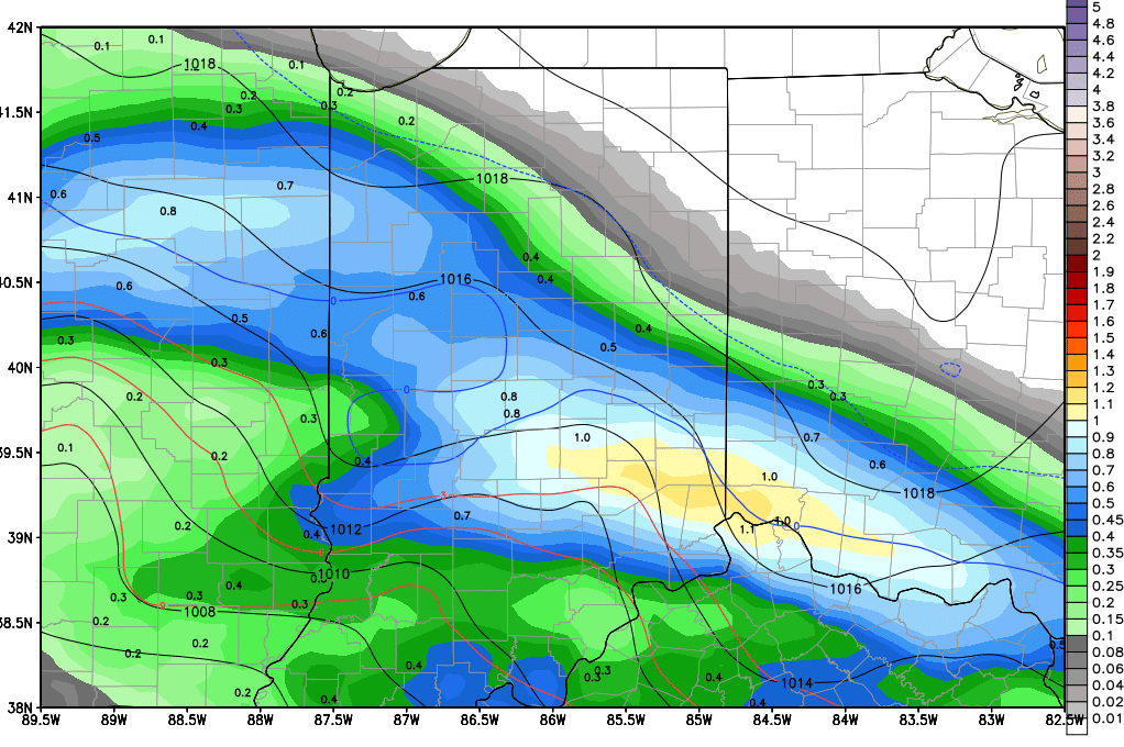
gfs_pr6_slp_t850_indy_22.pngThat system moves in for Saturday. Rain totals will easily be .25”-1” over the entire state, unchanged from yesterday’s thoughts. The upper end of the range will from potential thunderstorm action later Saturday afternoon and evening, mostly from central Indiana back into northeast IL. All rains still look to be done by Sunday morning but as temperatures fall behind the front, we are opening the possibility that the precipitation ends as wet snow over a large part of the state. We can see minor accumulations of a coating to an inch once again.  The map above is a snapshot of potential action Sunday evening

Dry for Sunday afternoon and Monday of next week. But, then the pattern becomes a little more active. WE have showers that move through overnight Monday night through Tuesday bringing .05”-.5” to about 70% of the state. Then we take a minor break with dry weather Tuesday night and Wednesday, followed by another batch of scattered showers for Thursday, adding another .25” over 60% of the state.

Moderate to heavy rains arrive for Easter weekend on the 31st and 1st. We are raising rain totals to .5”- 2” over 100% of the state. This will be a very moisture laden system. But then we go dry for the 2nd through the 5th for the remainder of the extended forecast window.

Indiana Weather Outlook 3-19-18

Most of the state misses out on moisture this week, but temperatures continue to look more like the last gasps of winter rather than full on spring. Wild swings in temps this week should finally give way to more stable, spring-like action next week.

Today, strong east winds will be seen over the state in advance of our next storm complex. This storm system will pass by mostly to the south of the state tonight through tomorrow. There will be some precipitation moving into far southern Indiana, mostly south of US 50, and we can see clouds with a small threat of precipitation all the way up to I-70. The precipitation totals south of US 50 will be up to half an inch, while closer to I-70 will be no more than a few hundredths. Coverage in the south tomorrow will be 80%. North of I-70, we see nothing but some clouds through tomorrow, and even those will have some breaks.

Colder air comes in on the backside of this system once again. Strong north winds will be seen at midweek on Wednesday. These winds will trigger some wrap around snows in Ohio, but we do not think that any of this action is able to move into Indiana, so we are keeping the period dry at this time. Clouds will be here, and temps will be below normal. That cool push continues through Thursday, and temps moderate some by Friday as south winds arrive ahead of the next front.

gfs_pr6_slp_t850_indy_24That system moves in for Saturday. Rain totals will easily be .25”-1” over the entire state. The upper end of the range will be in central Indiana, where we see an increased threat of thunderstorm action later Saturday afternoon and evening. All rains will be done by Sunday morning and we are in fact looking at full rain here, with temps staying closer to normal and perhaps even a bit above normal during the event. The map above is a snapshot of potential precipitation for Saturday afternoon.

Dry for Sunday, Monday and Tuesday of next week. A strong front will be coming together to the west for Monday into Tuesday, but it slows and stalls over IL Tuesday night and Wednesday morning. There is moisture potential in that front of .25”-1” and it could hit all of the state…but the movement of the system is interesting. IF it stalls for more than 24 hours…that would put way too much rain over areas to our west, but could also rain the storm out before it finally gets here. We think that this storm will likely pick up the pace and move right on in for Wednesday, and we like those .25”-1” rains here at midweek next week, with a dry finish for Thursday and Friday.

The rest of the extended window has a system for Easter weekend on the 31st and 1st, bringing .25”-75” rain potential to about 70% of the state. However, temps look to stay normal to slightly above normal for the entire extended period.

Indiana Weather Outlook 3-16-18

One more dry day today with sunshine and cool, but not cold temps. Winds will start to ramp back up later this afternoon. Clouds roll in overnight.

Rain for tomorrow is farther north again. At this time we are removing restriction in our forecast as to where the action will stay out of. In fact, we can see 70% coverage of moisture over the state past midnight tonight through early afternoon tomorrow. We are also bumping our rain totals a bit to a few hundredths to .4”. With cold air in play, and with action starting overnight in spots, we still feel that we have to allow for some wet snow in there, mixing with some rain. Minor accumulations can be seen, especially north of I-70. Everything looks to be done by late afternoon and tomorrow evening.

We are dry for Saturday night, Sunday and Monday, with sunshine and blue sky back in over the state for Sunday. Clouds build Monday, and by Monday night we see scattered showers moving in. However, action for Monday night and Tuesday looks to have a smaller footprint and may be confined to the southern half to third of the state. We will make a final determination on this in our forecast Monday morning. Rain totals can be from .25”-5” in those areas. Clouds will be around over the rest of the state.

The biggest change in our forecast this morning comes for next Wednesday. As a strong nor’easter heads up the east coast, we see ample wrap around action on the backside of the low, and it may trigger snow over Indiana. We can see a coating to an inch or two in spots, with the best snow potential in eastern and northeastern parts of the state. It will be far worse to our east, but we need to stress not to underestimate this storm. Yes, it is hundreds of miles to our east, but the flow around the top will reach all the way back here, and will be enhanced by movement across the great lakes.

The rest of the forecast is basically unchanged. We dry down for next Thursday and Friday, but stay cool. Then a front starts to work in for the 24th that has plenty of south flow ahead of it. That should take temps slightly above normal, and then also allow for good rains to fill in later Saturday afternoon through Sunday. Models have diminished the size and scope of this system this morning, but we are not changing the forecast yet. We will revisit this early next week. For now, we are calling for .25”-.75” rains for the 24th-25th with coverage at 70%.

The extended pattern shows a strong circulation still for the 27th and 28th. Models suggest we can see the gulf bring up some nice moisture into this low, triggering moderate to heavy rains. It’s early but we are considering raising our rain totals for that part of the forecast period to 1-2 inches, based on a track right across from central MO to Toledo. There is plenty of time for this to change, but this may be a wet finish to the month of March.


Indiana Weather Outlook 3-15-18

Our forecast pattern is basically unchanged this morning. We have at least 2 more dry days statewide, today and tomorrow. Temps will be near normal, but winds stay brisk enough for us to feel a chill. We should see temps climb into the 40s and low 50s.


Our weekend wave is trending a little farther north this morning. Generally, this is part of a low pressure circulation that’s moving from IA and northern MO into the OH and TN valleys, on its way to becoming yet another potential “nor’easter” for the east coast early next week. But its track is farther north, and so we have to allow for a few hundredths up to a quarter in all the way up to near the US 24 corridor, and we may even see some action north of that in far NW Indiana, coming out of the Chicago area. Still the movement of the moisture is southeast, meaning it should miss a large part of NE Indiana, and other areas as well. The second wrinkle is that colder air is in over the state as the moisture moves though, so we may have to keep an eye out for wet snows in northern Indiana with this, and rain farther south. Everything still looks to be done by afternoon.


We are dry for Saturday night, Sunday and Monday now, with sunshine and blue sky back in over the state for Sunday. Clouds build Monday, and by Monday night we see scattered showers moving in. The rains continue off and on through Tuesday, changing to snow late Tuesday afternoon and Tuesday night over northern Indiana, from US 24 northward. Strong north and northwest winds keep lake effect snow potential in here for early Wednesday morning, and we won’t rule out some accumulations up north through Wednesday. This will look similar to the setup we had a couple days ago on Tuesday: cold air and a nice lake effect set up…but this time we have more moisture in the atmosphere to start with.


Dry for next Thursday and Friday, but cool. Then a front starts to work in for the 24th that has plenty of south flow ahead of it. That should take temps slightly above normal, and then also allow for good rains to fill in later Saturday afternoon through Sunday. We can see .25”-.75” rains for the 24th-25th with coverage at 70%.


The extended pattern shows a strong circulation still for the 27th and 28th. Models suggest we can see the gulf bring up some nice moisture into this low, triggering moderate to heavy rains. It’s early but we are considering raising our rain totals for that part of the forecast period to 1-2 inches, based on a track right across from central MO to Toledo. There is plenty of time for this to change, but this may be a wet finish to the month of March.


The rest of the extended period will try and confirm that, as another front is being projected for arrival around the 30th.