Author: weatherstud

Indiana Weather Outlook 2-26-18

Rain is finally done for a few days over Indiana. We saw the sun for the first time in a while yesterday afternoon, and we should see good sunshine potential in most areas today, tomorrow and Wednesday. High pressure sits just east of the state this morning over Ohio, and will slowly work its way eastward. As it does so, we should see some south flow come up the backside of the high, and that will promote a slight moderation of temps. The state stays mostly dry, but there is one caveat, and that comes at midweek on Wednesday. That day, we see a wave passing bay mostly south of the Ohio River. WE like rains in KY and WV Wednesday, and we are leaving open the possibility that some minor moisture drifts north of the Ohio River over southern Indiana. We would be talking mostly about the far southern tier counties, particularly in SW Indiana, but the clouds from this would likely extend up to the I-70 corridor. So, while most of the state is dry through midweek, the pattern turns “more gray” over southern Indiana toward Wednesday.

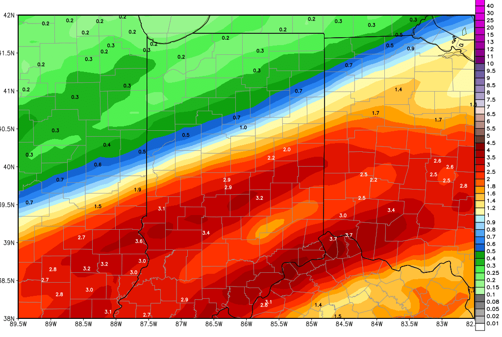
Our next solid system moving across the state comes Thursday. Low pressure tracks across NW Indiana Thursday and brings rain totals of .25”-1” to 80% of the state during the day. Cold air whips in behind the low as it move over the great lakes, and we have concern for some wrap around moisture over northern Indiana while the cold air races in. We need to leave the door open to some snow Thursday night as the system leaves from US 24 northward. This is up in the air, and we are not going crazy with the potential just yet, but this is a strong low. Winds will make this a dramatic event, with winds likely in the 20-40 mph range overnight Thursday night into early Friday, which would make any snow up north an absolute pain to deal with. So, we will keep an eye on this event. Generally on the rain side through the day, most of the state will be under half an inch…but the outliers could deliver the higher totals.

Back to drier weather for Friday through next Monday morning. High pressure will slowly work through the state Saturday afternoon through Sunday morning. Cold air holds over the region to finish the week and start the weekend, only moderating once we get south flow on the backside of that high.

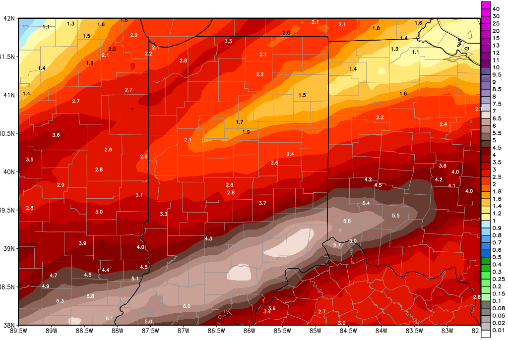
A cold front brings rain back for Monday afternoon through the first part of Tuesday, the 5th into the 6th. Rains do not look as impressive this morning, and will mostly be from .25”-.5” with coverage at 60% of the state. Colder air follows on the backside.

The extended period has us mostly devoid of new precipitation to start, through the 9th. Then we have 2 significant waves moving across the eastern Corn Belt from the 10th through the 12th. Combined, these waves can bring half to 1.5” rain totals, and likely will deliver below normal temps around mid-month. Still, the pattern does not look nearly as active as what we just got done with this past week…so we should be seeing improvement in our drainage conditions through the next couple of weeks.


Indiana Weather Outlook 2-23-18

A little good news this morning: we are rolling back rain totals just a bit over the rest of this week and weekend. We will not be rain free, but it looks like rains today and tomorrow will be less than we had seen (and feared). We still have potential for heavy rain overnight tomorrow night into early Sunday, but the geographical footprint is smaller. Here is how we see this working out.

Today, we have rain moving through the state. Rain totals will be mostly from .25”-.5” but we won’t rule out an occasional .75” amount here or there. The rain moves through fairly quickly, and will be done in most areas by early afternoon. Only far southern Indiana will see action linger into evening. This will allow a bit of a lull through the afternoon and tonight. Rain returns tomorrow and will bring potential for another .25”-.75” over the state with 80% coverage.

Overnight tomorrow night into Sunday morning we see a cold front bring significant rain and thunderstorm action to areas south and east of a line from Decatur to Terre Haute. This will be the last wave of moisture for this very active, rainy week. From this event, we can see 1-2.5” of rain south and east of the above mentioned line, but only a few hundredth to a quarter of an inch north and west of that line. Those rains will be very intense and we expect flooding problems to manifest in central and southern Indiana. But, the system is also moving quickly, and we should be completely done with rain statewide by midday Sunday. The map below shows moisture through Sunday evening, and keep in mind most of this happens overnight Saturday night through Sunday midday.

gfs_tprecip_indy_14.png

Drier weather finally arrives for Sunday afternoon and we see dry, sunny, rain free weather for Monday through Wednesday.

Thursday afternoon through Friday we have rains returning to the region. We look for .1”-.5 rains over 70% of the state. We follow that up with at least 3 more dry days, and may not see our next system until the 6th, where we can pick up half to 1.5” rains. The rest of the extended forecast is drier.

As far as temperatures go for the next 10 days, we look for temps to warm some this weekend with strong south flow ahead of that cold front for overnight Saturday into Sunday. Then temps will be normal to slightly below for next week. However, we still stay warm enough to be looking at mostly rain next Thursday into Friday.


Indiana Weather Outlook 2-22-18

Rain has spread back into the state this morning, and the pattern continues to unfold along the lines we have laid out earlier this week. That means from today through early Sunday morning, the focal point for heavy rain switches to central and southern Indiana. This does not mean we rule out rain up north…but rather we see it being lighter than what happens farther south. Rains today can bring half to 1.5” rains into southern Indiana with nearly 100% coverage, and up north .1”-.5” with 60% coverage. Far northern areas may miss out on most of the action, which is good, as they continue to deal with flooding from earlier in the week.

Tomorrow we have another wave coming up from the southwest. This will bring rains of .5”-2” to areas south of I-70, and a few hundredths to a quarter of an inch north of I-70. Far northern parts of Indiana may miss out on that system.

Saturday, scattered showers are back with .25”-.75” over 90% of the state.

A strong cold front is back for overnight Saturday night and will bring us our last chance of heavy rains. We can see rains of half to 2” in central and southern Indiana, up to half an inch up north. The rains linger through Sunday mid-morning, but should be east of us by shortly afternoon. We may be able to pick up another few hundredths to half an inch during that early Sunday period.

Dry for Sunday afternoon through next Wednesday night. High pressure moves across the region during that period.

Our next system arrives a little later on Thursday, and lasts a bit longer. We see showers nosing into Indiana Thursday midday and early afternoon, and then the rains continue through the overnight and through at least the first half of Friday.  We are lowing rain totals just a bit, to a quarter to 1 inch, and the heaviest rains will be over the southern half of the state.

In the extended 11-16 day forecast period we have a cold front that crosses the state around the 6th with potential for half to 1.5” rains. The rest of the extended forecast is drier. Temperatures the rest of this 10 day period will be closer to normal, and we do not see huge warm surges as we go into March.


Indiana Weather Outlook 2-21-18

We have no change in our outlook this morning. A cold front is trucking across the state, and brought heavy rain into NW Indiana going back into last night. The front moves southeast through the day today, and rain should end in northern Indiana first, before tapering off in southern Indiana toward evening. Temps are markedly different behind the front, dropping a good 15-25 degrees from yesterday’s record levels. Strong winds will be seen as well. Rains from this front will come to half to 2 inches and rain coverage will be up to 100% of the state. Flooding is already a problem in some areas, and will become a problem in many more over the coming days.

Another wave of moisture comes up the slowing front from the southwest for Thursday morning. This brings another chance at half to 1.5” rains into southern Indiana for Thursday. The clouds around this wave get all the way into northern Indiana, and moisture can lift north of I-70, but we think the northern quarter of the state probably is able to miss out on this moisture surge and stay dry for Thursday, while the south gets potentially hammered again.

From there, pretty much everything stays the same. Friday we have another wave coming up from the southwest. This will bring rains of .5”-2” to areas south of I-70, and a few hundredths to a quarter of an inch north of I-70. Far northern parts of Indiana may miss out on that system.

Saturday, scattered showers are back with .25”-.5” from US 24 southward, and a few hundredths to a quarter of an inch up north. Coverage will be 80%.

gfs_tprecip_indy_22.png

Rains still look to move our relatively fast for Sunday. We keep scattered showers around through the morning and they can bring .25”-.5” over about 60% of the state. But, we are removing potential for heavy Sunday rains, and we are also looking for a rain-free afternoon. We hesitate to call it a dry afternoon, though, after days of moderate to heavy rain. We are going to feel “damp” for a little while here.  The map above shows updated rain totals from this morning through Sunday.

We finally get several dry days in all areas of the state for next Monday through Wednesday. High pressure moves over the eastern Corn Belt during that period.

A strong system returns for the start of March on Thursday the 1st, pushing into the 2nd. This system brings rains again, with half to 1.5” potential on the conservative side. Late in the 11-16 day window we have a cold front that crosses the state around the 6th with potential for half to 1.5” rains.