Author: weatherstud

Indiana Weather Outlook 5-3-18

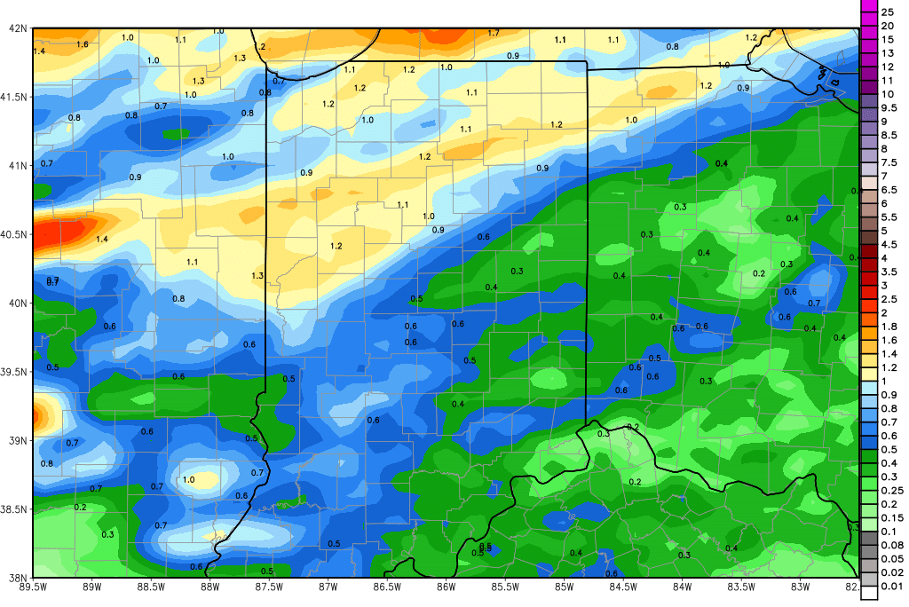
Rain and thunderstorm action moves across the region today and tomorrow. Rains in the north kicked off a little early, with some strong thunderstorms in last night. This was driven mostly by the heating of the past couple of days, creating an unstable atmosphere. The front is still about 18-24 hours from passing. Of course, the rest of the state saw basically nothing last night. That being said, we believe that today will feature more general showers and garden variety thunderstorms. There is a threat of strong to severe thunderstorm action in central and southern IN this afternoon and evening, but not so much farther north this time around. Scattered showers linger through Friday. Rain totals remain at .25” to 1.25” for today and tomorrow, with coverage at 90%.  The map above shows our expected distribution of moisture combined through midnight Friday night.

ecmwf_tprecip_indy_12.png

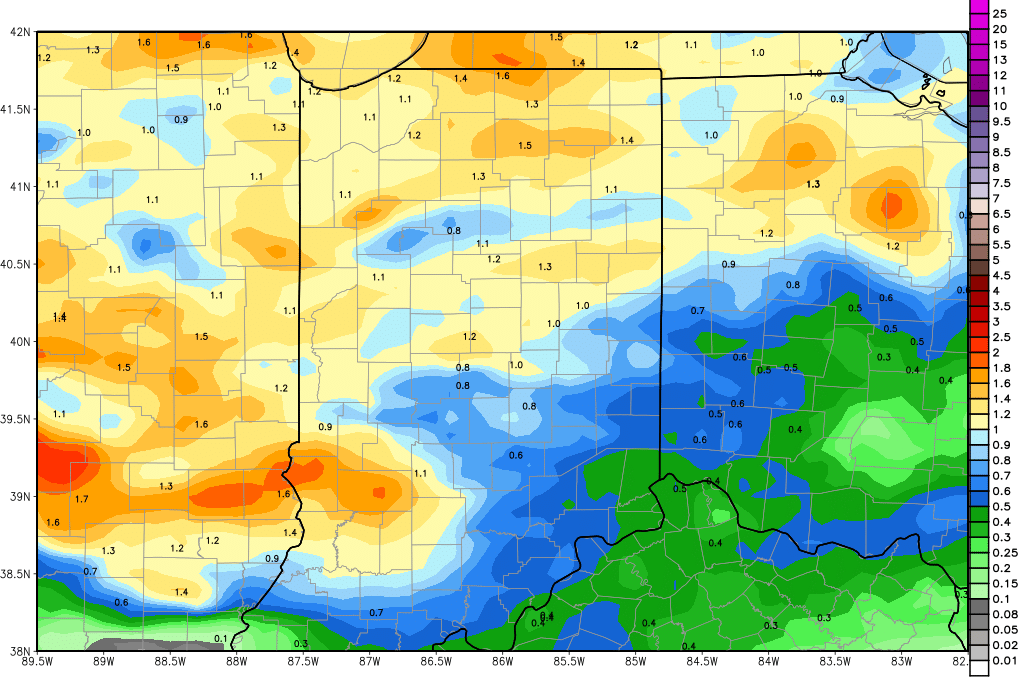
We are dry for the balance of Friday evening through Saturday, and then the pattern gets a little more interesting. Scattered light showers move in Sunday afternoon with clouds ahead of that. Moisture is not all that impressive, but we won’t rule out up to .25” of rain over 60% of the state for Sunday afternoon-evening and overnight. There may be a little action Monday, but in general, we see clouds slowly give way to sun. Then we are dry Tuesday and Wednesday.

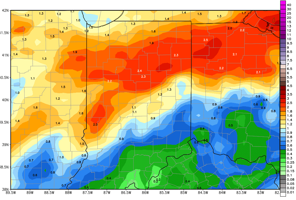
Rain on Thursday brings potential for .25”-1” over 90% of the state. Then we are dry for Friday. There is a chance for half to three quarter inch rains on Saturday, then going dry Sunday. Showers are around in the 11-16 day extended period for Monday the 14th with potential of .25”-1”, and then again possibly on Thursday, the 17th, with minor totals. The problem is, the only system out of those 4 that we have good model agreement on is the one for next Thursday. The rest of them are shown on different models at different times. However, the every other day to every 2 days set up is a common one we see in spring over the eastern Corn Belt, so we will not discount it at the moment. Even if we miss one of those, though, the result is the same…we do not see a long, consecutive dry period like we just got through at all over the coming 2 and a half weeks.


Indiana Weather Outlook 5-2-18

Today looks very similar to yesterday. The setup is the same. Strong southwest winds bring temps to above normal levels. Low humidity will bring more drying. This will be the last dry day before our front arrives.

We are leaving our forecast for tomorrow and Thursday entirely unchanged. Rain starts the day tomorrow morning as an approaching cold front works into Illinois. However, the front is relatively slow moving, as it still has a couple of pulses of low pressure to move up it through Friday midday. . Scattered showers hold through the rest of the day and through early afternoon Friday. The best chance for stronger rain and thunderstorms will be overnight tomorrow night, but the threat is minimal at this time. We are putting rain totals at .25” to 1.25”. That features a lowering of the lower range level, and the upper end stays the same. Even that inch and a quarter total will take some thunderstorms to get to. The most general rain totals remains in that half to 1 inch range.

We are dry for the balance of Friday through the Saturday. Clouds and a little moisture are back on Sunday, particularly in the afternoon. WE will keep an eye out for a few hundredths to a tenth or two over northern Indiana on Sunday, but think that coverage may end up being only around 50%. We are still not convinced this is a good disturbance to watch, but it has been pretty resilient over the past few model runs, so we are opening the door for some action.

We are dry again for Monday, Tuesday, Wednesday and the first part of Thursday. That dry stretch is why it we are very interested in the potential of rain on Sunday…because if we happen to miss it, we should get another field work window!

Rain is back for next Thursday afternoon (the 10th) and we see on and off moisture holding through the 13th. That multi day event can bring combined rain totals of half to 1.5” with 90% coverage. As that circulation moves off to the east, we see the remainder of the 11-16 day period mostly dry, as high pressure parks right over the Great Lakes. Temperatures still look to be early normal to slightly below normal under that high.

Indiana Weather Outlook 5-1-18

Dry and warm today and tomorrow. Southwest winds take temps up well above normal for the first time in weeks. We will see low relative humidity, high evaporation and excellent drying.

The timing and overall set up of our next rain event is unchanged. We have rain to start the day Thursday morning with an approaching cold front. Scattered showers hold through the rest of the day and through early afternoon Friday. The best chance for stronger rain and thunderstorms will be overnight Thursday night, but we see this event as less threatening now for the state. If we see any action, it again will be north, but we think the best chance for strong to severe weather will be farther west and north. So, because of lower thunderstorm chances, we are lowering our overall rain totals. Right now we look for half to 1.25”, and even that inch and a quarter total will take some thunderstorms to get to. Really, this will be a pretty good rain event, with most of the state falling in the half to 1 inch range. Coverage will be around 90%. The map above shows rain potential through Saturday morning.

ecmwf_tprecip_indy_20.png

We are dry for the balance of Friday through the Saturday. AT this point, we see clouds and a little moisture trying to develop for Sunday, but we hesitate to put much action in yet. We will take a look at additional data tomorrow morning and make a decision on whether we need to insert a quarter inch of liquid for the latter part of the weekend. Either way, we are dry again for Monday.  On Tuesday, we still see the potential for a few minor spits and sprinkles near the Michigan line, but nothing anywhere else. There can be a few hundredths to a tenth or two around.

Dry for next Wednesday. A strong system arrives for Thursday the 10th and lingers through the 13th. That event can bring half to 1.5” rains to 90% of the region. As that circulation moves off to the east, we see the remainder of the 11-16 day period mostly dry, as high pressure parks right over the Great Lakes. Temperatures will be nearly normal to slightly below normal under that high.


Indiana Weather Outlook 4-27-18

A little bit of rain in the forecast for today, as a cold front works through the state. The best chances for moisture come this afternoon through midnight tonight. That does not mean action is limited to that time, we may see some scattered showers in NW Indiana already this morning…but the best chances of moisture are later today and tonight. We are leaving moisture totals at a few hundredths to .25” from I-70 northward. Coverage will be near 70% in the northern half of the state. We still think south of I-70, we see nothing.

All action is done by sunrise tomorrow. We should see a dry weekend emerge as clouds break up and sunshine returns. However, much colder air is in behind today’s front, and that means we see temps fall off. Tomorrow will be a good 10-15 degrees below normal for this time of year, and we will see temps dip to below freezing in parts of northern Indiana overnight Saturday night into Sunday. So, there can be some patchy frost. This will be aided by clearing Saturday night too. Temps begin to bounce on Sunday with sunshine, and we continue to climb from there. With southwest winds returning to start the week, we see temps climb to their first above normal level by next Tuesday and Wednesday as we knock on the door of 80 degrees up north and move into the mid and upper 80s farther south. This warming will be ahead of our next front for the second half of next week.

That front is on track to bring ran and thunderstorms starting Thursday. Now, as clouds build Wednesday, we won’t rule out some scattered action trying to drift in to parts of the state – of note will be NW and west central Indiana. But, generally, we are looking at the rain really picking up in frequency and intensity on Thursday. Rain totals Thursday will be from .25”-1.5” with coverage at 70% of the state. To get to the upper end of the range, thunderstorms will be needed and the best chances of those, as it stands right now, will be Thursday evening and overnight. Then, we see rains hold on, perhaps through the entire day Friday over southern Indiana. This can add an additional .25”-.75” from I-70 southward and a quarter inch or less farther north. Finally on Saturday we get all action out of Indiana pushing off to the east. WE should be dry for the weekend, but cooler once again. The map below shows total rains through the end of next week, the majority of which comes from that front next Thursday and Friday.

gfs_tprecip_indy_35.png

For the extended period, we have a minor disturbance moving over northern Indiana for the 7th, part of a stronger low in the upper Midwest. That likely triggers only a few scattered showers worth up to .25” and 40% coverage. Our front for the 9th looks stronger, bringing .25”-.75” to 80% of the state, and then we will be watching a wave coming out of OK and AR on Saturday the 12th, as it may hook right across the state before the day is done. That system would have potential for strong to severe thunderstorms if it holds together and tracks correctly.

After the front next week, as we mentioned, we cool off. We expect those cooler temps to hold through the extended window, where we see temps mostly normal to below normal.