Author: weatherstud

Indiana Weather Outlook 4-6-18

Light snow leaves northeast Indiana this morning, and most of the state turns out partly sunny for a good chunk of today. However, we do have another wave of moisture coming through tonight. We do have good news this morning, though! The action in southern Indiana is not going to be nearly as problematic! The heaviest moisture is staying farther south, and action is highly diminished across Indiana tonight through tomorrow. We will have some light snow and flurry action in overnight tonight, bringing a fresh coating in central Indiana, and then this action drifts south and east toward daybreak. We won’t completely rule out snow accumulations near the river, but instead of 1-4”, we are looking at a coating to at most an inch. And, action will be done by shortly after sunrise! This is a fantastic improvement in weather. Cold air is still here, but the winter precipitation event is a significantly lower threat, and there is a chance we can see a large part of southern Indiana miss out on snow entirely!


Sunshine should start to emerge again tomorrow by midday, and then we have high pressure in control through Sunday. While temps remain cold, we do not see as much of a chill as earlier this week.


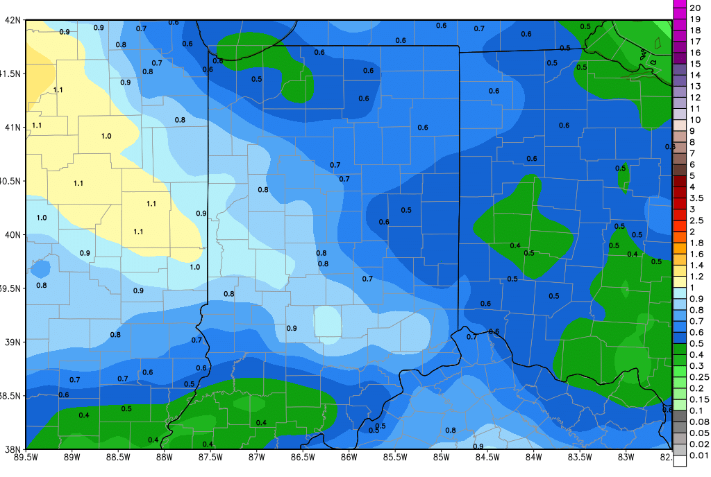
Our next system is still on the way for Sunday night and Monday, but precipitation has a much shorter duration in central and southern Indiana. Air is cold enough to still look for snow. We are lowering the top end of the range for snow accumulation overnight Sunday night to a coating to 1” over 80% of the state. While action is done in southern Indiana by Monday afte4rnoon, a second wave late Monday lingers into Tuesday in northern Indiana, bringing an additional threat of snow, with some rain mixing in. Additional precipitation will be under .1” liquid equivalent, and will be mostly north of SR 26. We stay dry farther south, and all areas of the state are dry next Wednesday, while cold air holds in for just a bit longer.


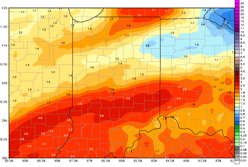
Thursday we keep rain in the forecast, but action is lighter. Look for a few hundredths to .3” over about 60% of the state. Then for Friday nothing more than a few scattered showers bring a few hundredths to a tenth over 40% of the state. The heaviest rains are backing up into Saturday now, with rain totals of .25”-1”, and action may not be completely done until sometime Sunday morning. WE will put combined rain totals at .5”-1.5”, which is down significantly on the top end from our prior forecast. Coverage of the combined rains in that range will be 80% of the state.


In the extended window, a few scattered wrap around showers may hold over the state for Sunday the 15th with only a few hundredths to a tenth or two. A much stronger front moves in for the 18th with rain totals of .5”-1.5”. That system will be followed by a minor wave on the 20th, bringing .25”-.5”. Strong, cooler high pressure could move in for the 21st going forward, and if is strong enough, will steer precipitation to the south. However, if that strength is there…it will also likely produce below normal temps again for the last 8-9 days of the month.


Indiana Weather Outlook 4-5-18

Partly sunny and cold today. Winds may not be as strong as yesterday, but will still be out of the NW. This will bring down our next wave of moisture tonight. Scattered light snow showers overspread northern Indiana, working in over the norther third of the state. We can see a coating to an inch or so, likely very similar to what we saw at the start of the day Wednesday up north. South of 24, we should see just clouds and a few flurries

Most of the state turns out partly sunny on Friday. However, this respite will be short lived. Light snow is back into the state Friday evening, where we can see a trace to a light coating over northern and central Indiana. Then the front really ramps farther south. From midnight Friday night through midday Saturday, we can see at least 1-4” from I-70 southward. This will be quite a mess to be dealing with Saturday morning. Northern parts of the state start dry Saturday, and the entire state is dry for the balance of Saturday afternoon and evening. High pressure moves over Indiana Sunday, setting up in Ohio. This should give us some good sunshine to finish the weekend.

Our next system begins to toy with the region Sunday night, but still will draw out its effects into Tuesday. Sunday night we have light snow coming into the northern half of the state, from I-70 northward. This will bring a coating to 2 inches, but we think most of the region will be under an inch. There will be nothing south. The daylight hours will be mostly dry Monday, and then light snow comes back from US 24 northward for Monday night into Tuesday morning. The action there will be limited to an additional coating at best, but the snow spreads into east central Indiana for Tuesday afternoon. Notice that we are leaving southern Indiana out of the coverage for this event…this will be good, because we still will be dealing with the aftermath of Saturday’s snows in the south. This will actually equalize moisture across the state a little bit for the period.

We are dry Wednesday. Thursday rains are here (yes, RAIN!!). But, they look to have the potential to be heavy. Right now we are looking at two waves coming through for Thursday and Friday, bringing combined rains of 1-2.5’ over 80% of the state. The heavier wave will be on Friday. Then we get a few dry hours Saturday morning.

In the extended window, we have .5”-1.5” rains for late next Saturday afternoon (14th) through Sunday (15th). These rains will have 100% coverage over the state. Spits and sprinkles linger for the 16th. Then, (and let’s not get too excited…this is far enough out it can easily change) we may be able to put together our longest dry stretch of the month! We see no precipitation for the 17th-18th-19th. Rain is back for the 20th, bringing .25”-.75”

Temperatures stay cold for the next week. We will be 10-20 degrees below normal now through next Wednesday. Then, we see temps climb quickly to above normal levels (in time to fuel the rain and thunderstorms) next Thursday and Friday. Behind that we are back to normal and below normal levels for the following weekend. The combination of cold air this week, ample moisture, and really only 2 above normal days out of the next 17 bring us to no change in our field work estimate: not getting in there for a while yet! Ten day moisture totals are below.

gfs_tprecip_indy_41.png

Indiana Weather Outlook 4-4-18

Rains blew past expectations yesterday. We way undershot the level of moisture that ended up coming through. But…even if there was more rain than we thought or wanted, it does not change our focus for today…and that is on cold air!

Cold air started to blast in to the north and northwest part of the state overnight and will continue to sink south and east through the day. This is triggering some snow over the northern third of the state, particularly in lake effect areas. In those areas (Laporte, St. Joe, et al) we can see a coating to an inch or two on grassy surface. The rest of the northern third, from US 24 northward, we can see sloppy wet snow flakes and perhaps some minor coatings. The central and southern parts of the state should be mostly precipitation free, but cloudy and cold. Temps struggle to get out of the mid-30s in the north, 40s in the south.

Clouds mix with some sun Thursday and then another fast moving wave of moisture moves in over the northern third of the state overnight Thursday night. This likely brings just clouds in most areas, but we will leave the door open to light snow and flurries that can leave a coating to an inch from US 30 northward from sunset Thursday night to sunrise Friday morning. The rest of the state looks dry through the daytime hours Friday.

Overnight Friday night through Saturday moisture pushes up over the southern half of the state. This will trigger mostly snow from I-70 southward, and the best accumulations will be from US 50 southward. Liquid equivalent precipitation will be from .25”-.6” meaning we can easily see several inches of snow in the south. Everything is done by Saturday midday.

The Saturday and Sunday look to be mostly dry. High pressure moves across the state Saturday and we have some minor south winds in for Sunday. Still, cold air rules the weekend, and we see only minor moderation in temps for Sunday. South and southeast winds do develop Sunday afternoon ahead of our next system to start next week, allowing temps to get back closer to normal.

Moisture is back to start next week. Overnight Sunday night low pressure moves into the state. The system brings two waves of moisture, both triggering mostly wet snow. The first wave from midnight Sunday through Monday brings a coating to an inch or two to about 70% of the state. Then a second wave moves through Tuesday, with more intense precipitation .WE can see several inches of snow over 60% of the state, and there can be some rain mixing in, mostly over the southern third of the state. Still, temps are cold enough for mostly snow.

We finally put together about 36 hours of dry weather for the entire state from Tuesday evening through all of Wednesday. Next Thursday, precipitation is back, but with south winds, temps moderate just enough to be looking at all rain. Temps will not be above normal, but will not be quite so cold.

So, to put it in blunt terms, we see no day over the next 10 with temps above normal, and 9 of them will be below to well below normal. This colder surge has caused us to have to talk up snow much more this morning, and lessen our thoughts of rain. Soil temps will stay in the 30s through mid-month…and there can be no talk what-so-ever on field work through mid-month either. It’s not what we want to hear, but it is the truth. The precipitation forecast may get tweaked, but make no mistake…the pattern is cold and damp. The maps below show total 10 day snow accumulations (now through next Friday) at top, and total 10 day liquid equivalent precipitation at bottom.

gfs_6hr_snow_acc_indy_41.pnggfs_precip_120hr_indy_41

Indiana Weather Outlook 4-3-18

A soggy Tuesday is expected today as rains move through the state. The heaviest rains this morning will be in southern Indiana, and later this afternoon and evening we see that threat farther north. Thunderstorms can happen and there even is an outside chance we see some strong to severe weather, although it’s not a big chance. Rain totals remain on track to be from .5” to 1.5” over 90% of the state, and the remaining 10% will see rain…but may fall short of that half inch lower boundary.  Temps today will be above normal, making the only day out of the next 10 to have that kind of temperature profile. The map above shows total precipitation potential through tomorrow morning.

gfs_tprecip_indy_8.png

Much colder air is on the way in for tomorrow. This cold air begins to blast in overnight tonight, but we think most of the moisture will be gone before it gets here. The northern part of the state still looks like it needs to expect some snowflakes here and there, mostly from US 24 northward, and in particular, in general lake effect locations. In some of those areas we won’t rule out a coating to an inch or two early Wednesday, but coverage of accumulation like that will be limited to about 30% of the northern third of the state. The rest of the north just sees flakes from time to time. South of US 24, we just see the cold air dominating at midweek. Parts of northern Indiana will struggle to get to the mid-30s Wednesday, and farther south, lower 40s will be a stretch.

Thursday should be dry statewide, and we see some sun in there. But, minor moisture moves in over the northern third of the state overnight Thursday night. This likely brings just clouds in most areas, but we will leave the door open to a few flurries and a bit of light snow from US 30 northward from sunset Thursday night to sunrise Friday morning. The rest of the state looks drier for Friday, as our southern wave has fallen apart.

Saturday and Sunday look to be mostly dry. High pressure moves across the state Saturday and we have some minor south winds in for Sunday. Still, cold air rules the weekend, and we see only minor moderation in temps for Sunday. South and southeast winds do develop Sunday afternoon ahead of our next system to start next week, allowing temps to get back closer to normal.

Next week still looks to start damp. Overnight Sunday night low pressure moves into the state, bringing .5” of liquid equivalent precipitation. However, colder air is looking to reassert itself, and we think that will lead to snow over a large part of the state. There is potential for a coating all the way up to 4” the way things look right now. This will be a wet snow, but without some kind of southern push, temps will be cold enough for snow. The cold lingers behind the initial system for Tuesday, when a second wave can come through (mostly in the morning) giving an additional .2”-.5” of liquid to central and southern Indiana, where some of that can come as a few more inches of snow.  Clouds dominate over the rest of the state with the cold temps for next Tuesday.

Mostly dry but still chilly next Wednesday, and then finally heading into Thursday, we have south winds starting to moderate temps a bit. We could get back to near normal for daytime highs by late next week.

The extended forecast is largely unchanged this morning. Our next system still looks to develop out of a low moving over the eastern Corn Belt for the 13th. This system is farther south than 24 hours ago, and therefore is likely a less drawn out feature. WE still will look for .25”- 1” of rain across for that time period, but can expect drier weather for the 14th and 15th. A weaker front arrives on the 16th, with the potential of .1”-.5” of rain for Indiana. Finally, expect a strong spring storm complex for the 18th, and rain totals look higher. Right now we will project half to 1.5” rains out of that system.

So, while we have some tweaks, generally our thought process is unchanged this morning. Cold and damp will be the buzzwords through the rest of this week and through midweek next week. Then, we continue to see a fairly active precipitation pattern, even when temps start to moderate a bit. Nothing here makes us change our thoughts on potential field work in the next few weeks at all.