Indiana Weather Outlook 2-20-18

Rains continue today. In fact, the only change we are making to our forecast this morning is to bring more rain into southern Indiana on Thursday.  Today’s rains should be a little lighter than yesterday, but we still see them lingering through most of the day over northern Indiana. As we mentioned in yesterday’s forecasts, we do see these rains extending a little bit to the south over far western Indiana today, and still think rain down to Vincennes in the west is likely. However, we do not see any southern push farther east, and that means south central and southeast Indiana will stay dry. South flow will be strong today, and temps will be well above normal. 60s and 70s will be seen statewide. Rain totals will be .2” to .5” from I-70 northward and in far western Indiana, those totals can extend south to Vincennes.

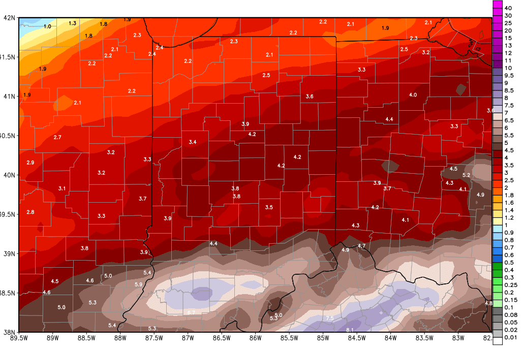
A strong cold front works through the state tomorrow. Thunderstorms are likely overnight tonight through tomorrow morning over the northern half of the state, and we see thunderstorms attempting to re-fire over southern Indiana tomorrow night. However, this front does more through quickly, allowing most of the state to see a lull in action by late afternoon and tomorrow evening. Much, much colder air comes in for tomorrow, with a good 20-25 degree drop from today’s highs. Rain totals will run from half to 2” and rain coverage will be up to 100% of the state.

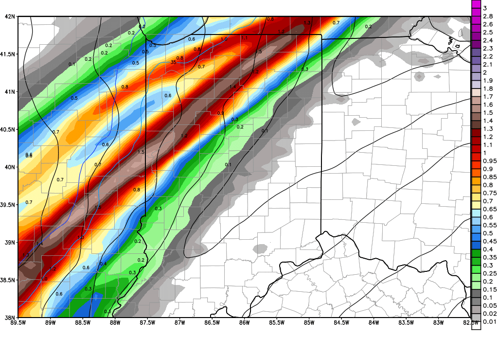
Another wave of moisture comes up the slowing front from the southwest for Thursday morning. This brings another chance at half to 1.5” rains into southern Indiana for Thursday. The clouds around this wave get all the way into northern Indiana, and moisture can lift north of I-70, but we think the northern quarter of the state probably is able to miss out on this moisture surge and stay dry for Thursday, while the south gets potentially hammered again.

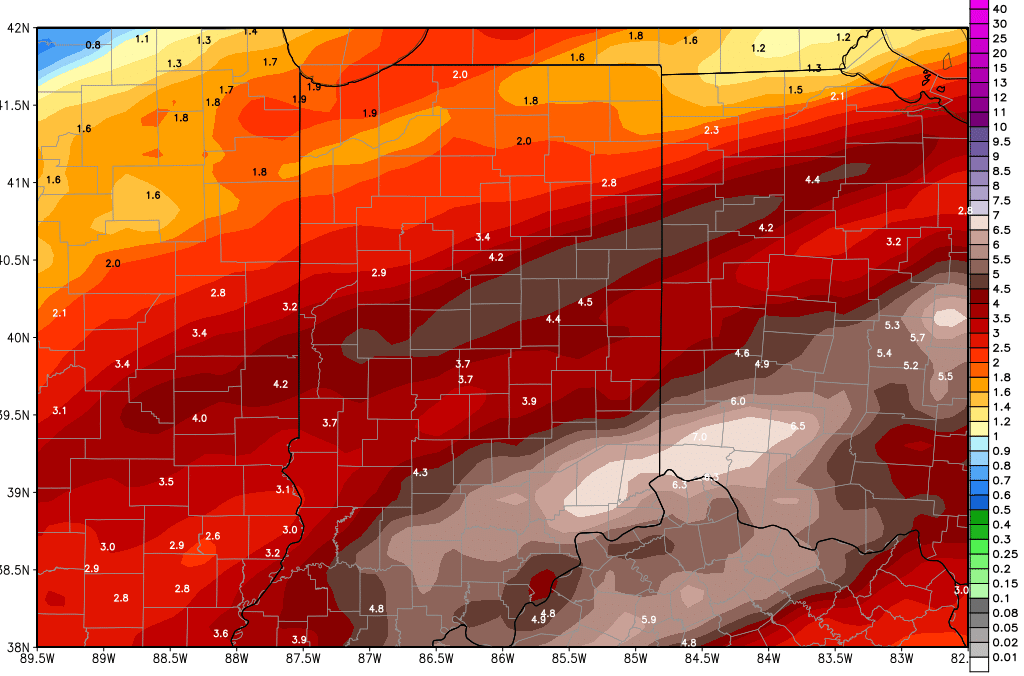
From there, pretty much everything stays the same. Friday we have another wave coming up from the southwest. This will bring rains of .5”-2” to areas south of I-70, and a few hundredths to a quarter of an inch north of I-70. Far northern parts of Indiana may miss out on that system.

Saturday, scattered showers are back with .25”-.5” from US 24 southward, and a few hundredths to a quarter of an inch up north. Coverage will be 80%.

gfs_tprecip_indy_26.png

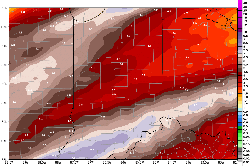
Sunday we are pushing the rains out sooner. We still look for potential rain totals of .5”-1.5” over the southern half of the state and scattered showers up north with potential of a quarter of an inch or so. But…everything looks to be done and out of here by midday Sunday, allowing for some drying to start later Sunday afternoon. The map above shows rain totals from this morning through Sunday.


We finally get a dry day in all areas of the state next Monday. In fact, we should be dry for at least 3 straight days Monday through Wednesday, as high pressure works across the eastern Corn Belt.


A strong system returns for the start of March on Thursday the 1st, pushing into the 2nd. This system brings rains again, with half to 1.5” potential on the conservative side. Late in the 11-16 day window we have a cold front that crosses the state around the 6th with potential for half to 1.5” rains.

Indiana Weather Outlook 2-19-18

A week of wet weather is here, and our forecast is actually wetter this morning than it was last time we talked last week. Now, not only do we see rains for the first half of the week, we see rains for the last half as well. Rains the first half of the week will have a slightly more northern bias, and rains the last half of the week will have a more southern bias. But, the results are that everyone sees more rain. The map below shows potential rain totals from now through Sunday. Here is how it all breaks down.

gfs_tprecip_indy_41

Rains today will work across the northern part of the state. .25”-1” rains are likely with 80% coverage from US 50 northward. Rains do not look like they will be able to carry all the way south today, meaning the southern quarter of the state misses out.

Rains tomorrow look a little lighter than today, but still should be worth .2” to .5” from I-70 northward, and we can see rains a little farther south over western parts of the state, perhaps pushing down closer to Vincennes. Once again, south central and southeast areas likely see little rains, but plenty of clouds.

Wednesday we have a strong front finally pushing in, and it will bring heavier rains. We see half to 2” rain totals over 90% of the state. The higher end of the range will be in northern and NW parts of the state, where thunderstorms are likely after midnight Tuesday through the overnight. Rains continue through the rest of the day as the front pushes south and east. Thunderstorms can re-fire Wednesday evening in southern Indiana, and run right on into Thursday morning.

Thursday will be mostly dry over the state but scattered showers hold on into early afternoon down near the Ohio River.

Friday we have another wave coming up from the southwest. This will bring rains of .5”-2” to areas south of I-70, and a few hundredths to a quarter of an inch north of I-70. Far northern parts of Indiana may miss out on that system.

Saturday, scattered showers are back with .25”-.5” from US 24 southward, and a few hundredths to a quarter of an inch up north. Coverage will be 80%.

Sunday has rains of .5”-2.5” over the southern half of the state again, and scattered showers up north with potential of a quarter of an inch or so.

We finally get a dry day in all areas of the state next Monday. In fact, we should be dry for at least 3 straight days Monday through Wednesday, as high pressure works across the eastern Corn Belt.

A strong system returns for the start of March on Thursday the 1st, pushing into the 2nd. This system brings rains again, with half to 1.5” potential on the conservative side. Late in the 11-16 day window we have a cold front that crosses the state but is part of a low that is centered farther north. That means we may miss the worst rains, but still can see up to half an inch around the 6th. The forecast pattern therefore can stay very wet with on through the first week of March.

Temps are mostly normal to above normal through the next 10 days, although we do cool down briefly this Thursday, and then again early next week behind strong cold fronts. But, the pattern does not show any significant cold air outbreaks through early March, meaning we expect mostly rain through the period.


Indiana Weather Outlook 2-16-18

Rains are winding down this morning, and we will take a little break before our next system. Colder air will funnel into the state from the NW through the day today, and we will see temps pull back from yesterday’s exceptionally mild push. However, we don’t get exceptionally cold, and the cold air does not stay. Rains through the first half of the day today will be mostly limited to southern Indiana, and by midafternoon we will be rain free statewide.

Dry to start the day tomorrow, but our next minor wave is coming a little quicker. This wave will act as a minor warm front as winds return to the southwest. We can expect scattered light precipitation from late tomorrow afternoon and through the overnight. This overrunning will be predominantly rain shower action, but over the northern third of the state we can see some sloppy wet snowflakes mix in. Moisture totals are unimpressive, at a few hundredths to .1” maximum. Still, it makes for a damp interlude in the middle of the weekend.

Sunday now looks mostly dry and warmer, since we are speeding up the aforementioned wave. Southwest winds will pick up through the day, and we should see well above normal temps. Clouds will build.

The start of next week still looks very wet. Rains start overnight Sunday night into Monday. We see 3 distinct waves coming through Monday through midweek. On Monday we can have .25”-1” rains with 100% coverage, which is a bump up from our previous forecasts. Tuesday, we can see a few hundredths to a third of an inch with 50% coverage, skewed north. This is a decrease from our previous forecasts. And for Wednesday, we see 1-2 inch rains with 90% coverage. There can be some thunderstorm action in there for Wednesday. Most of the Wednesday action happens early, from Midnight through noon. Combined rain totals for the first half of the week can be at least 1-3 inches, over the entire state. The map below shows a snapshot of next Wednesday morning, shortly after midnight, when the heaviest rains may be trying to develop.

ecmwf_slp_precip_indy_24.png

Drier and cooler behind that action. We dry down Wednesday night, and then stay dry Thursday into early Friday. A southern wave moves across central and southern Indiana Friday midday and afternoon, bringing .05”-.4” rains with 80% coverage south of I-70. This is a new addition to our forecast. Then we are dry for Saturday, but have a massive system looking to arrive overnight Saturday night through Sunday.

The second half of the weekend will feature moderate to heavy rains from that system. WE expect half to 1.5” rains over 90% of the state. Temps remain mild as the precipitation falls, meaning we are looking at all rain. However, cold air races in on the backside of the circulation, so there is potential to have to talk about some snow next Sunday night into Monday.


The extended period remains keen on a system for the 28th into the 1st. This system sweeps through the entire eastern Corn Belt, and may bring half to 1” rains. The heavier rains look to stay a little farther south, and that is why we have reduced our top end on this system this morning.


Temperatures look to be mostly normal to above normal through the next 10 days. The last few days of February and the start of March look like they could turn colder…but we have plenty of time to see that set up change.

Indiana Weather Outlook 2-15-18

Very foggy over parts of the state this morning as we continue to see very mild air moving in over a cold surface. The worst fog is over northern Indiana where we are seeing significant snow melt put plenty of vapor into the air. Still, rain is on the way today, and it should dissipate the thickest fog just a bit. Rains today will be somewhat minor, as scattered showers develop from midday on through this afternoon and evening. Today’s totals look to be from a few hundredths up to perhaps half an inch. But, rains increase in intensity tonight, and there will be a band of heavy rains along and south of the I-70 corridor as we approach midnight. Rains continue into tomorrow morning, but will be ending north to south. After sunrise, we still see some showers from US 50 down to the river, but they will end by early afternoon. All told, today through tomorrow we see rain totals of half to 1.25” with coverage at 80% of the state. The remaining 20% of the state will see some rains, but may not make it to that half inch lower end of our general rain spectrum.

We dry down tomorrow afternoon and stay dry through Saturday. Cold air will be pushing in behind the system, allowing for some single digit lows Saturday morning over northern Indiana. However, that cold air does not stay, and the Canadian high bringing it moves quickly off to the east. That should allow south winds to develop Saturday afternoon and ramp up to rather breezy levels. Temps will rise with the help of the south wind.

Scattered light precipitation will sneak in overnight Saturday night into Sunday, but totals are not that impressive. We will look for a few hundredths to at most a quarter of an inch of rain in there, but coverage will be limited to 60% of the state. We do not like this set up that much, and think that a large part of the moisture may end up just hanging out as clouds, but it is something we need to watch for. Sunday afternoon we likely are done with action.

Next week looks very wet for Monday through Wednesday. We have rains of .25”-.5” on Monday, .25”-.5” Tuesday, and 1-2 inches for Wednesday. There can be some strong storms and very heavy rains in there at midweek. All told, rains for the first half of the week can be 1-3 inches. This will put the exclamation point on a wet 6 day period. The cumulative rain totals map (updated) is below for today through next Thursday morning. We do dry down some behind that last wave on Wednesday, allowing for 3 days precipitation free for Thursday, Friday and Saturday.

gfs_tprecip_indy_32.png

In the extended window, we still have chances for a couple of systems, but the one that stands out the most is a strong low pressure circulation that moves through at the end of the month, for the 28th and 1st. This low has ample moisture, a strong core, and plenty of temperature change to work with. WE see potential for half to 1.5” of liquid equivalent. March still looks like it wants to come in like a lion.